Ingatestone railway station
| Ingatestone | |
|---|---|
|
The Grade II listed station building in 2013 | |
| Location | |
| Place | Ingatestone |
| Local authority | Borough of Brentwood |
| Grid reference | TQ649991 |
| Operations | |
| Station code | INT |
| Managed by | Abellio Greater Anglia |
| Number of platforms | 2 |
| DfT category | D |
|
Live arrivals/departures, station information and onward connections from National Rail Enquiries | |
| Annual rail passenger usage* | |
| 2010/11 |
|
| 2011/12 |
|
| 2012/13 |
|
| 2013/14 |
|
| 2014/15 |
|
| National Rail – UK railway stations | |
| * Annual estimated passenger usage based on sales of tickets in stated financial year(s) which end or originate at Ingatestone from Office of Rail and Road statistics. Methodology may vary year on year. | |
|
| |
_(geograph_3493816).jpg)
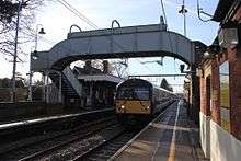
Ingatestone railway station is on the Great Eastern Main Line in the East of England, serving the village of Ingatestone, Essex. It is 23 miles 50 chains (38.0 km) down-line from London Liverpool Street and is situated between Shenfield to the west and Chelmsford and to the east. Its three-letter station code is INT.
The station and all trains serving it are currently operated by Abellio Greater Anglia.
History
The first station at Ingatestone was opened by the Eastern Counties Railway (ECR) in July 1843, sited just below Stock Lane, and operated for less than a month. The station consisted of wooden platforms on each side of the railway, connecting to the road carried above by wooden steps up the embankment.
However, the agreement for the construction of the railway across the Petre Estate, obtained in 1836, and section 7 of the enabling private Act of Parliament (An Act to amend and enlarge the powers and provisions of the Act relating to the Eastern Counties Railway) in 1838 both required that the Petre Estate consent to the construction of any station on the estate.
The railway obtained consent for the construction of a station adjacent to Old Hall Lane (now Station Lane), adjacent to the level crossing, subsequently the site of the existing station. Despite this, in August 1842 the railway requested permission to relocate the station to the cutting adjacent to the Stock Lane bridge, a change that Lord Petre refused to agree. Despite this, a station was constructed on the alternative site, and opened on 22 July 1843 for services between Shoreditch in London and Colchester.
Following the legal case of Lord Petre v Eastern Counties Railway Company in August 1843, an injunction was issued by the High Court prohibiting use of the Stock Lane station. As a result, a permanent station on the present site was opened in 1844 and certainly given the present main station building, in Tudor style with diaper brickwork, in 1846. The up-side buildings (now not largely in railway use) were provided by the Great Eastern Railway (GER) in 1885 to a domestic revival design by W. N. Ashbee.[1][2][3]
Ingatestone station and the area around it form one of the first conservation areas to be designated in Essex. The railway station is a Grade II listed building.
Services
The typical off peak service on Monday-Saturday is two trains per hour to London Liverpool Street, and one each to Clacton-on-Sea and Braintree. On Sundays, there is one train per hour to London Liverpool Street, and one to Ipswich.
The services are operated by Abellio Greater Anglia.
References
- ↑ Paar, Harry; Gray, Adrian (1991). The Life and Times of the Great Eastern Railway 1839-1922. Welwyn Garden City: Castlemead. ISBN 0-948555-26-2.
- ↑ Quick, M.E. (2005). Railway Passenger Stations in England and Wales: a chronology. Richmond, Surrey: Railway & Canal Historical Society.
- ↑ Kay, Peter (2006). Essex Railway Heritage. Wivenhoe: Peter Kay. ISBN 978-1-899890-40-8.
External links
| Wikimedia Commons has media related to Ingatestone railway station. |
| Preceding station | |
Following station | ||
|---|---|---|---|---|
| Abellio Greater Anglia | ||||
| Historical railways | ||||
| Anglia Railways | ||||
Coordinates: 51°40′01.03″N 0°23′02.33″E / 51.6669528°N 0.3839806°E