Ingapirca
| Hatun Cañar / Inka Pirka | |
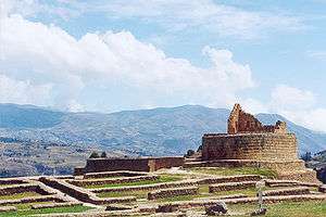 Ingapirca, the temple of the sun | |
 Quito Ingapirca Ingapirca (Ecuador) | |
| Region | Cañar Province |
|---|---|
| Coordinates | 2°32′54.9168″S 78°52′18.768″W / 2.548588000°S 78.87188000°WCoordinates: 2°32′54.9168″S 78°52′18.768″W / 2.548588000°S 78.87188000°W |
| History | |
| Cultures | Inca |
| Site notes | |
| Public access | yes |
| Website | http://www.complejoingapirca.gob.ec/ |

Ingapirca (Kichwa: Inka Pirka, "Inca wall") is a town in Cañar Province, Ecuador, and the name of the older Inca ruins and archeological site nearby.[1][2]
These are the largest known Inca ruins in Ecuador.[3] The most significant building is the Temple of the Sun, an elliptically shaped building constructed around a large rock. The building is constructed in the Inca way without mortar, as are most of the structures in the complex. The stones were carefully chiseled and fashioned to fit together perfectly. The Temple of the Sun was positioned so that on the solstices, at exactly the right time of day, sunlight would fall through the center of the doorway of the small chamber at the top of the temple. Most of this chamber has fallen down.
Ingapirca had long been settled by the Cañari indigenous people, who called it Hatun Cañar. As the Inca Empire expanded into southern Ecuador, the Inca Túpac Yupanqui encountered the Cañari "Hatun Cañar" tribe and had difficulties in conquering them. In a second attempt, he used different political strategies, marrying the Cañari princess and improving the Cañari city of Guapondelig, calling it Pumapungo (nowadays Cuenca).
The Inca and Cañari decided to settle their differences and live together peacefully. The astronomical observatory was built under Inca Huayna Capac. They renamed the city and kept most of their individual customs separate. Although the Inca were more numerous, they did not demand that the Cañari give up their autonomy.
The castle complex is of Cañari-Inca origin. The objective of its construction is uncertain. The complex played an important role as a fortress and storehouse with which to resupply troops en route to northern Ecuador. At Ingapirca they developed a complex underground aqueduct system to provide water to the entire compound.
The people had numerous ritual celebrations on the complex. Gallons of a local fermented drink were used in these festivals. As sun and moon worshippers, they tried to be as close to their gods as possible. The weather changes rapidly, within minutes, ranging from calm and sunny one minute and rainy, windy, and cold another minute. This climate volatility is typical year round. The people felt strongly that this was the place where the gods had led them, regardless of the climate.
| Wikimedia Commons has media related to Ingapirca. |
Tourism
To visit Ingapirca, travelers can take a day tour from the city of Cuenca or spend the night in the towns of El Tambo or Cañar.
Map

See also
References
- ↑ Hyslop, John (19 February 2014). Inka Settlement Planning. Austin, Texas: University of Texas Press. p. 384. ISBN 9780292762640. Retrieved 13 November 2014.
- ↑ Greenspan, Eliot (1 June 2011). Frommer's Ecuador and the Galapagos Islands (3rd ed.). USA: Frommer's. p. 214. ISBN 9781118100325. Retrieved 13 November 2014.
- ↑ Lauderbaugh, George (22 February 2012). The History of Ecuador. Westport, Connecticut: Greenwood Publishing Group. p. 5. ISBN 9780313362514. Retrieved 13 November 2014.