Inchmurrin
| Gaelic name | Innis Mheadhran |
|---|---|
| Meaning of name | St Mirin's Island |
| Location | |
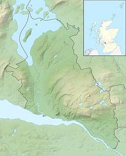 Inchmurrin Inchmurrin shown within West Dunbartonshire | |
| OS grid reference | NS379871 |
| Physical geography | |
| Island group | Loch Lomond |
| Area | 120 hectares (0.46 sq mi)[1] |
| Area rank | 139= (Freshwater: 1) [2] |
| Highest elevation | 89 metres (292 ft) |
| Administration | |
| Sovereign state | United Kingdom |
| Country | Scotland |
| Council area | West Dunbartonshire |
| Demographics | |
| Population | 8[3] |
| Population rank | 70= (Freshwater: 1) [2] |
| Pop. density | 6 people/km2[1][3] |
| References | [4] |
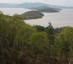
Inchmurrin (Scottish Gaelic: Innis Mheadhran) is an island in Loch Lomond in Scotland. It is the largest fresh water island in the British Isles.[5]
Geography and geology

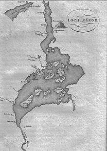
Inchmurrin is the largest and most southerly of the islands in Loch Lomond. It reaches a height of 89 metres (292 ft) towards the north and is largely wooded.[6] There is an excellent view of the north end of the loch.[7]
Along with Creinch, Torrinch, and Inchcailloch, Inchmurrin forms part of the Highland boundary fault.[5]
History
Inchmurrin was the site of a 7th-century monastery, with a chapel dedicated to Saint Mirin, after whom it was named.
The island was formerly a deer park of the Dukes of Montrose, who had a hunting lodge built in 1793 and maintained a gamekeeper and his family there.[8] 200 deer are recorded in 1800.[9] There are ruins of Lennox Castle,[8] probably built for Duncan, 8th Earl of Lennox whose seat was Balloch Castle at the south end of Loch Lomond.[5] The castle was probably a hunting lodge for the deer park established on the island by King Robert I of Scotland in the early 14th century.[10] After her husband Murdoch Stewart, Duke of Albany, father Donnchadh, Earl of Lennox, and two sons were executed by James I in 1425, Isabella Countess of Lennox retired to the castle on Inchmurrin with her grandchildren.[7]
In 1417, Iain Colquhoun of Luss was killed here by robbers.[5] Sir John Colquhoun of Luss, governor of Dumbarton Castle, was murdered at Inchmurrin in 1439, during a raid led by Lachlan MacLean.[11][12]
In 1617, James VI made his only return visit to Scotland, and included Inchmurrin in his itinerary to go hunting. Lord Lennox wrote to the custodian of the island on July 23, 1617 asking for food to be prepared for "a good nombre of sharpe stomaches", probably a reference to the hunting trip.[7]
Rob Roy raided the island. At one point, his men came to control all the boats on the River Endrick and Loch Lomond, which were later used to remove cattle from Inchmurrin.[5]
Inchmurrin was used as a mental asylum, and also unmarried pregnant women were sent here to give birth.[5]
The English travel writer, H.V. Morton visited Inchmurrin in the 1930s and described it as "the grassy isle, an island packed with memories."[7]
The island has been owned by the Scott family for over 70 years. They farm it and run self-catering apartments, a cottage, and restaurant.[13] They used to have a sign at the jetty saying, "You are now entering Scott Country".[5]
The World Record for haggis hurling was held by Alan Pettigrew for over 20 years. He threw a 1 lb 8 oz haggis 180 feet, 10 inches on Inchmurrin in August 1984. However this was beaten when a new record was set at 217 feet by Lorne Coltart at the Milngavie Highland Games on 11 June 2011.[14]
Facilities
As well as offering self catered accommodation in the form of 3 flats and an 8-person cottage, the island has its own bar and restaurant, open from Easter to October. Inchmurrin is licensed to hold civil ceremonies.
There is a naturist camp in the north east of the island.[5]
Footnotes
- 1 2 Rick Livingstone’s Tables of the Islands of Scotland (pdf) Argyll Yacht Charters. Retrieved 12 Dec 2011.
- 1 2 Area and population ranks: there are c. 300 islands over 20 ha in extent and 93 permanently inhabited islands were listed in the 2011 census.
- 1 2 National Records of Scotland (15 August 2013) (pdf) Statistical Bulletin: 2011 Census: First Results on Population and Household Estimates for Scotland - Release 1C (Part Two). "Appendix 2: Population and households on Scotland’s inhabited islands". Retrieved 17 August 2013.
- ↑ Ordnance Survey: Landranger map sheet 56 Loch Lomond & Inveraray (Map). Ordnance Survey. 2012. ISBN 9780319229811.
- 1 2 3 4 5 6 7 8 Worsley, Harry (1988). Loch Lomond: The Loch, the Lairds and the Legends. Glasgow: Lindsay Publications. ISBN 978-1-898169-34-5.
- ↑ "Overview of Inchmurrin". Gazetteer for Scotland. Retrieved 2007-08-23.
- 1 2 3 4 Morton, H. V. (1933). In Scotland Again. London: Methuen.
- 1 2 Wilson, Rev. John (1882). The Gazetteer of Scotland. Edinburgh: W. & A.K. Johnstone.
- ↑ Garnett, T. (1800). Observations on a Tour of the Highlands ... London. V.1. p. 39.
- ↑ "Lennox Castle". aboutScotland.com. Retrieved 2007-08-23.
- ↑ "John Colquhoun". RootsWeb. Retrieved 2008-09-25.
- ↑ "The history of Lennox castle and Inchmurrin Island". Self Catering Loch Lomond. Retrieved 2008-09-25.
- ↑ "Loch Lomond Islands - Inchmurrin". Loch Lomond.net. Retrieved 2007-08-23.
- ↑ "Did You Know?". The Haggis.com. Retrieved 29 August 2013.
External links
- http://www.inchmurrin-lochlomond.com/ - official website
- http://www.lochlomond-islands.com/
- article which mentions it
|  | ||||||||||||||||||||||||||||
|
| |||||||||||||||||||||||||||||
| |||||||||||||||||||||||||||||
| |||||||||||||||||||||||||||||
| |||||||||||||||||||||||||||||
| |||||||||||||||||||||||||||||
| |||||||||||||||||||||||||||||
| |||||||||||||||||||||||||||||
Coordinates: 56°03′N 4°36′W / 56.050°N 4.600°W