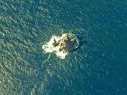
Inamba-jima
| Native name: <span class="nickname" ">藺灘波島 | |
|---|---|
 | |
 | |
| Geography | |
| Location | Izu Islands |
| Coordinates | 33°39′03″N 139°17′56″E / 33.65083°N 139.29889°E |
| Archipelago | Izu Islands |
| Area | 0.005 km2 (0.0019 sq mi) |
| Length | 120 m (390 ft) |
| Width | 70 m (230 ft) |
| Highest elevation | 74 m (243 ft) |
| Administration | |
|
Japan | |
| Demographics | |
| Population | 0 |
Inamba-jima (藺灘波島 or イナンバ島 Inanba-jima) is a volcanic, deserted island located in the Philippine Sea approximately 220 kilometres (140 mi) south of Tokyo and 35 kilometres (22 mi) southwest of Mikura-jima, in the center of the Izu archipelago, Japan.
Geography
The island is an andesite pillar with sheer sides, the only visible portion of a submarine volcanic caldera. The above sea-level portion has a surface area of approximately 0.005 square kilometers, with a summit height of 74 metres (243 ft). Located in the Kuroshio Current, the area has abundant sea life, and is popular with sports fishermen and scuba divers.
See also
External links
- Quaternary Volcanoes in Japan
- Entry at Oceandots.com at the Wayback Machine (archived December 23, 2010)
This article is issued from Wikipedia - version of the 11/17/2016. The text is available under the Creative Commons Attribution/Share Alike but additional terms may apply for the media files.