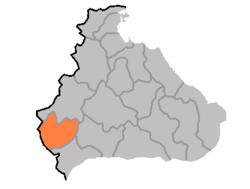
Ichon County
| Ich'ŏn County 이천군 | |
|---|---|
| County | |
| Korean transcription(s) | |
| • Chosŏn'gŭl | 이천군 |
| • Hancha | 伊川郡 |
| • McCune-Reischauer | Ich'ŏn-gun |
| • Revised Romanization | Icheon-gun |
 | |
| Country | North Korea |
| Province | Kangwŏn Province |
| Administrative divisions | 1 ŭp, 22 ri |
Ich'ŏn County is a kun, or county, in northern Kangwŏn province, North Korea. The terrain is predominantly high and mountainous; the highest point is Myongidoksan, 1,585 meters above sea level. The county's borders run along the Masingryong and Ryongam ranges. The chief stream is the Rimjin River.
Administrative Divisions
Ich'ŏn county is divided into 1 ŭp (town) and 22 ri (villages):
|
|
Economy
Agriculture
Agriculture is limited to the low-lying regions. Sericulture (silk farming) is also practised. Due to the abundant woods, lumbering is also an important industry.
Mining
There are deposits of gold, asbestos, nickel and lead in the county.
Transport
Ich'ŏn is served by roads, and by the Ch'ŏngnyŏn Ich'ŏn line of the Korean State Railway.
See also
External links
- (Korean) In Korean language online encyclopedias:

This article is issued from Wikipedia - version of the 12/16/2015. The text is available under the Creative Commons Attribution/Share Alike but additional terms may apply for the media files.