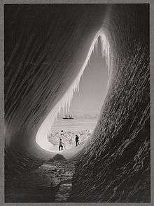
Iceberg

An iceberg or ice mountain is a large piece of freshwater ice that has broken off a glacier or an ice shelf and is floating freely in open water.[1][2] It may subsequently become frozen into pack ice (one form of sea ice). As it drifts into shallower waters, it may come into contact with the seabed, a process referred to as seabed gouging by ice. Almost 90% of an iceberg is below the surface of the water.
Etymology
The word "iceberg" is a partial loan translation from German Eisberg, literally meaning ice mountain,[3] cognate to Danish isbjerg, Dutch ijsberg, Low Saxon Iesbarg and Swedish isberg.
Overview
Because the density of pure ice is about 920 kg/m³, and that of seawater about 1025 kg/m³, typically only one-tenth of the volume of an iceberg is above water (due to Archimedes's Principle). The shape of the underwater portion can be difficult to judge by looking at the portion above the surface. This has led to the expression "tip of the iceberg", for a problem or difficulty that is only a small manifestation of a larger problem.
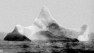
Icebergs generally range from 1 to 75 metres (3.3 to 246.1 ft) above sea level and weigh 100,000 to 200,000 metric tons (110,000 to 220,000 short tons). The largest known iceberg in the North Atlantic was 168 metres (551 ft) above sea level, reported by the USCG icebreaker East Wind in 1958, making it the height of a 55-story building. These icebergs originate from the glaciers of western Greenland and may have an interior temperature of −15 to −20 °C (5 to −4 °F).[4]
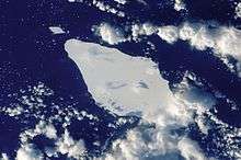
Icebergs are usually confined by winds and currents to move close to the coast. The largest icebergs recorded have been calved, or broken off, from the Ross Ice Shelf of Antarctica. Iceberg B-15, photographed by satellite in 2000, measured 295 by 37 kilometres (183 by 23 mi), with a surface area of 11,000 square kilometres (4,200 sq mi). The largest iceberg on record was an Antarctic tabular iceberg of over 31,000 square kilometres (12,000 sq mi) [335 by 97 kilometres (208 by 60 mi)] sighted 150 miles (240 km) west of Scott Island, in the South Pacific Ocean, by the USS Glacier on November 12, 1956. This iceberg was larger than Belgium.[5]
When a piece of iceberg ice melts, it makes a fizzing sound called "Bergie Seltzer". This sound is made when the water-ice interface reaches compressed air bubbles trapped in the ice. As this happens, each bubble bursts, making a 'popping' sound. The bubbles contain air trapped in snow layers very early in the history of the ice, that eventually got buried to a given depth (up to several kilometers) and pressurized as it transformed into firn then to glacial ice.[4]
Recent large icebergs

- Iceberg B-15 11,000 km2 (4,200 sq mi), 2000
- Iceberg A-38, about 6,900 km2 (2,700 sq mi), 1998[6]
- Iceberg B-15A, 3,100 km2 (1,200 sq mi), broke off 2003
- Iceberg C-19, 5,500 km2 (2,100 sq mi), 2002
- Iceberg B-9, 5,390 km2 (2,080 sq mi), 1987
- Iceberg B-31, 615 km2 (237 sq mi), 2014[7]
- Iceberg D-16, 310 km2 (120 sq mi), 2006
- Ice sheet, 260 km2 (100 sq mi), broken off of Petermann Glacier in northern Greenland on Aug 5, 2010, considered to be the largest Arctic iceberg since 1962.[8] About a month later, this iceberg split into two pieces upon crashing into Joe Island in the Nares Strait next to Greenland.[9] In June 2011, large fragments of the Petermann Ice Islands were observed off the Labrador coast.[10]
- Iceberg B-17B 140 km2 (54 sq mi), 1999, shipping alert issued December 2009.[11]
Shape

%E2%80%93Iceberg_01.jpg)
In addition to size classification, icebergs can be classified on the basis of their shape. The two basic types of iceberg forms are tabular and non-tabular. Tabular icebergs have steep sides and a flat top, much like a plateau, with a length-to-height ratio of more than 5:1.[12] This type of iceberg, also known as an ice island,[13] can be quite large, as in the case of Pobeda Ice Island. Antarctic icebergs formed by breaking off from an ice shelf, such as the Ross Ice Shelf or Filchner-Ronne Ice Shelf, are typically tabular. The largest icebergs in the world are formed this way.
Non-tabular icebergs have different shapes and include:[14]
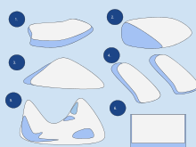
- Dome: An iceberg with a rounded top.
- Pinnacle: An iceberg with one or more spires.
- Wedge: An iceberg with a steep edge on one side and a slope on the opposite side.
- Dry-Dock: An iceberg that has eroded to form a slot or channel.
- Blocky: An iceberg with steep, vertical sides and a flat top. It differs from tabular icebergs in that its shape is more like a block than a flat sheet.
Monitoring

Icebergs are monitored worldwide by the U.S. National Ice Center (NIC), established in 1995, which produces analyses and forecasts of Arctic, Antarctic, Great Lakes and Chesapeake Bay ice conditions. More than 95% of the data used in its sea ice analyses are derived from the remote sensors on polar-orbiting satellites that survey these remote regions of the Earth.
The NIC is the only organization that names and tracks all Antarctic Icebergs. It assigns each iceberg larger than 10 nautical miles (19 km) along at least one axis a name composed of a letter indicating its point of origin and a running number. The letters used are as follows:[15]
- A – longitude 0° to 90° W (Bellingshausen Sea, Weddell Sea)
- B – longitude 90° W to 180° (Amundsen Sea, Eastern Ross Sea)
- C – longitude 90° E to 180° (Western Ross Sea, Wilkes Land)
- D – longitude 0° to 90° E (Amery Ice Shelf, Eastern Weddell Sea)
Iceberg B15 calved from the Ross Ice Shelf in 2000 and initially had an area of 11,000 square kilometres (4,200 sq mi). It broke apart in November 2002. The largest remaining piece of it, Iceberg B-15A, with an area of 3,000 square kilometres (1,200 sq mi), was still the largest iceberg on Earth until it ran aground and split into several pieces October 27, 2005, an event that was observed by seismographs both on the iceberg and across Antarctica.[16] It has been hypothesized that this breakup may also have been abetted by ocean swell generated by an Alaskan storm 6 days earlier and 13,500 kilometres (8,400 mi) away.[17][18]
History
In the 20th century, several scientific bodies were established to study and monitor the icebergs. The International Ice Patrol, formed in 1914 in response to the April 1912 sinking of the Titanic, which killed 1,517 of its 2,223 passengers, monitors iceberg dangers near the Grand Banks of Newfoundland and provides the "limits of all known ice" in that vicinity to the maritime community.
Technology history
Before the early 1910s there was no system in place to track icebergs to guard ships against collisions, most likely because they weren't considered a serious threat back then, ships have managed to survive even direct crashes. In 1907 SS Kronprinz Wilhelm, a German liner, had rammed an iceberg and suffered a crushed bow, but was still able to complete her voyage. The April 1912 sinking of the Titanic however changed all that, and created the demand for a system to observe icebergs. For the remainder of the ice season of that year, the United States Navy patrolled the waters and monitored ice flow. In November 1913, the International Conference on the Safety of Life at Sea met in London to devise a more permanent system of observing icebergs. Within three months the participating maritime nations had formed the International Ice Patrol (IIP). The goal of the IIP was to collect data on meteorology and oceanography to measure currents, ice-flow, ocean temperature, and salinity levels. They published their first records in 1921, which allowed for a year-by-year comparison of iceberg movement.
New technologies monitor icebergs. Aerial surveillance of the seas in the early 1930s allowed for the development of charter systems that could accurately detail the ocean currents and iceberg locations. In 1945, experiments tested the effectiveness of radar in detecting icebergs. A decade later, oceanographic monitoring outposts were established for the purpose of collecting data; these outposts continue to serve in environmental study. A computer was first installed on a ship for the purpose of oceanographic monitoring in 1964, which allowed for a faster evaluation of data. By the 1970s, icebreaking ships were equipped with automatic transmissions of satellite photographs of ice in Antarctica. Systems for optical satellites had been developed but were still limited by weather conditions. In the 1980s, drifting buoys were used in Antarctic waters for oceanographic and climate research. They are equipped with sensors that measure ocean temperature and currents.

Side looking airborne radar (SLAR) made it possible to acquire images regardless of weather conditions. On November 4, 1995, Canada launched RADARSAT-1. Developed by the Canadian Space Agency, it provides images of Earth for scientific and commercial purposes. This system was the first to use synthetic aperture radar (SAR), which sends microwave energy to the ocean surface and records the reflections to track icebergs. The European Space Agency launched ENVISAT (an observation satellite that orbits the Earth's poles)[19] on March 1, 2002. ENVISAT employs advanced synthetic aperture radar (ASAR) technology, which can detect changes in surface height accurately. The Canadian Space Agency launched RADARSAT-2 in December 2007, which uses SAR and multi-polarization modes and follows the same orbit path as RADARSAT-1.[20]
See also
- List of recorded icebergs by area
- Drift ice station
- Ice calving
- Ice drift
- Polar ice cap
- Polar ice pack (disambiguation)
- Polynya
- Sea ice
- Seabed gouging by ice
- Shelf ice
References
- ↑ "Definitions of the word "Iceberg"". Google. Retrieved 2006-12-20.
- ↑ "Common Misconceptions about Icebergs and Glaciers". Ohio State University.
Icebergs float in salt water, but they are formed from freshwater glacial ice.
- ↑ "Iceberg". Online Etymology Dictionary. Retrieved 2006-03-26.
- 1 2 "Facts on Icebergs". Canadian Geographic. Retrieved 2010-12-08.
- ↑ "Antarctica shed a 208-mile-long berg in 1956". Polar Times. 43. 2005-01-20. p. 18.
- ↑ "Iceberg A-38B off South Georgia". Visible Earth. Retrieved 2011-03-09.
- ↑ Brad Lendon, CNN (22 April 2014). "Iceberg is twice the size of Atlanta - CNN.com". CNN.
- ↑ "Huge ice sheet breaks from Greenland glacier". BBC. 2010-08-07. Retrieved 2011-03-09.
- ↑ "Massive Iceberg Crashes Into Island, Splits in Two".
- ↑ "Massive ice island heading for southern Labrador". CBC News. 2011-06-23.
- ↑ "Shipping alert issued over giant iceberg". Associated Press. December 11, 2009.
- ↑ "Sizes and Shapes of Icebergs" (PDF). International Ice Patrol. Retrieved 2006-12-20.
- ↑ Weeks, W.F. (2010), On Sea Ice, University of Alaska Press, p. 399
- ↑ "Iceberg Physiology". Canadian Geographic. Retrieved 2006-12-20.
- ↑ "New Iceberg Breaks off Ronne Ice Shelf in Antarctica". NOAA. 15 October 1998. Retrieved 2011-03-09.
- ↑ Martin, S., Drucker, R., Aster, R., Davey. F., Okal E., Scambos T., and MacAyeal, D., Kinematic and seismic analysis of giant tabular iceberg breakup at Cape Adare, Antarctica, J. Geophys. Res., 115, B06311, doi:10.1029/2009JB006700, 2010
- ↑ "Alaskan storm cracks giant iceberg to pieces in faraway Antarctica".
- ↑ MacAyeal, D., Okal, E., Aster, R., Basis, J., Brunt, K., Cathles, L. Mac. Drucker, R., Kim, Y-J., Martin, S., Okal, M., Sergienko, O., Sponsler, M., Thom, J., Transoceanic wave propagation links iceberg calving margins of Antarctica with storms in tropics and northern hemisphere, Geop. Res. Lett., 33, L17502, doi:10.1029/2006GL027235, 2006
- ↑ "Envisat". European Space Agency. Retrieved 2011-03-09.
- ↑ "Tracking Monsters". Canadian Geographic. Retrieved 2006-03-29.
External links
| Wikimedia Commons has media related to Iceberg. |
- Iceberg Finder Service for east coast of Canada
- Icebergs of The Arctic and Antarctic
 Works related to Iceberg at Wikisource
| Crystalline types | |||||||
|---|---|---|---|---|---|---|---|
| Formations and phenomena |
| ||||||
| Ice-related activities |
| ||||||
| Constructions | |||||||
| Work | |||||||
| Other uses | |||||||
| Ice ages | |||||||
| |||||||