Ibi River
| Ibi River | |
|---|---|
|
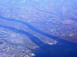
Ibi River (left) flowing into Ise Bay. To the right is Kiso River. | |
| Native name | 揖斐川 |
| Country | Japan |
| Basin | |
| Main source |
Mount Kanmuri 1,257 m (4,124 ft) |
| River mouth | Ise Bay |
| River system | Kiso River |
| Basin size | 1,840 km2 (710 sq mi) |
| Physical characteristics | |
| Length | 121 km (75 mi) |
| Discharge |
|
The Ibi River (揖斐川 Ibi-gawa) is a tributary of the Kiso River located in Gifu and Mie Prefectures in Japan. Along with the Nagara and Kiso rivers, the Ibi is the third of the Kiso Three Rivers of the Nōbi Plain. It is one of Japan's first-class rivers. The former Tōkaidō post station of Kuwana-juku was located on the western banks of this river during the Edo period.
Geography
The Ibi River has its source in Mount Kanmuri,[1] which is located in the town of Ibigawa in Gifu Prefecture, and from there flows south. During its course, it temporarily merges with the Kiso and Nagara Rivers. In the city of Kuwana, Mie Prefecture, it finally joins with the Nagara River for good and continues flowing until Ise Bay.
River communities
Gifu Prefecture
Anpachi, Gōdo, Ibigawa, Ikeda, Kaizu, Mizunami, Ōno, Ōgaki, Wanouchi, Yōrō
Mie Prefecture
Additional notes
- Every year, on the second Sunday of November, there is a marathon in Ibigawa, which goes along the river's shores.[2]
- Kuwana is considered the meeting point between Kansai dialect and Nagoya dialect.
References
- ↑ Tokuyama Dam and the Ibi River. (Japanese) Japan Water Agency. Accessed June 27, 2008.
- ↑ Ibigawa Marathon Public Site. Ibigawa Marathon Committee. Accessed September 18, 2007.
External links
35°03′57″N 136°42′07″E / 35.065927°N 136.701972°ECoordinates: 35°03′57″N 136°42′07″E / 35.065927°N 136.701972°E (confluence with Nagara River)