Mensor terrain model generation system
|
| |
| Developer(s) | Mark A. O'Neill |
|---|---|
| Written in | C |
| Operating system | Linux, BSD Unix |
| Available in | English |
| License | proprietary |
| Website | http://www.tumblingdice.co.uk/mensor/ |
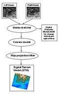
The Mensor/ITG digital terrain model generation system is a stereo correspondence/automated change detection algorithm based on adaptive least squares correlation for generating digital terrain models and detecting change using multiple digital images.

Developed by Mark A. O'Neill, it utilises stereoscopic image analysis techniques developed during doctoral research at University College, London. This was initially used for terrain modelling utilising SPOT-1 stereo imagery, but can also use other sorts of stereo image, for example, other forms of satellite imagery (e.g ASTER), aerial photographs and large scale imagery (e.g. human facial imagery).[1] At larger scales, stereo aerial photography for Mensor can be captured using low cost UAV's for example the Arducopter drone.
Mensor can also be used for change detection. It has been used in this mode to identify areas of gross change in satellite images (e.g. detecting areas of deforesatation in Amanzonia, looking at flooding in the Himalayas and estimating effects of earthquakes in Greece and Turkey). At large scales, Mensor has been used as a (template) face and fingerprint classifier and as a tool in functional magnetic resonance imaging, FRMI.
References
- ↑ O'Neill, Mark A.; Denos, Mia (April 1996). "Automated System for Coarse-to-Fine Area Corellation Stereomatching". Image & Vision Computing. 14 (3): 225–236. doi:10.1016/0262-8856(95)01061-0.
External links
- http://www.tumblingdice.co.uk/mensor/ Mensor page at Tumbling Dice Ltd