IJssel
| IJssel | |
| Gelderse IJssel | |
| River | |
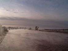
 Sunset on the IJssel at Deventer | |
| Country | Netherlands |
|---|---|
| Province | Gelderland, Overijssel |
| Regions | Liemers, Veluwe, Achterhoek, Salland |
| Tributaries | |
| - right | Oude IJssel, Berkel, Schipbeek |
| Cities | Arnhem (suburbs), Doesburg, Zutphen, Deventer, Zwolle (suburbs), Kampen |
| Source | Nederrijn |
| - location | Westervoort, Gelderland, Netherlands |
| Mouth | Ketelmeer (inlet of lake IJsselmeer) |
| - location | Kampen, Salland, Overijssel, Netherlands |
| - coordinates | 52°34′58″N 5°50′24″E / 52.58278°N 5.84000°ECoordinates: 52°34′58″N 5°50′24″E / 52.58278°N 5.84000°E |
| Length | 125 km (78 mi) |
| Discharge | |
| - average | 340 m3/s (12,007 cu ft/s) |
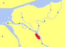
 Location of river IJssel in dark blue. | |
The River IJssel (Dutch pronunciation: [ˈɛi̯səl]), sometimes called Gelderse IJssel ("Gueldern IJssel") to avoid confusion with the Hollandse IJssel, is the branch of the Rhine in the Dutch provinces of Gelderland and Overijssel. The Romans knew the river as Isala. The IJssel flows from Westervoort, east of the city of Arnhem, until it discharges into the IJsselmeer ("Lake IJssel", known prior to the 1932 completion of the Afsluitdijk as the Zuiderzee, a North Sea inlet). The River IJssel is one of the three major distributary branches (along with the rivers Nederrijn and Waal) into which the Rhine divides shortly after crossing the German-Dutch border.
The name includes the digraph ij, which behaves like a single letter in Dutch orthography - this explains why both letters appear capitalized (compare: IJmuiden and IJsselmeer).
History
The name IJssel (older Isla, Isala, from *Īsalō), is thought to derive from a Proto-Indo-European root *eis- "to move quickly" (cf. Old Norse eisa "to race forward", Latin ira "anger").[1] In the Middle Ages, the Zuiderzee had not yet formed, and in its place there was an inland lake known as Vlies (Lat. Flevo), and the IJssel flowed through the surrounding lakelands. However, since the formation of the Zuiderzee and obstruction from the Afsluitdijk, the IJssel no longer flows into its estuary, the Vlie, now restricted in meaning and referring only to the strait separating the islands of Vlieland (itself named after the Vlie strait) and Terschelling. It is hypothesised that the now-poldered tidal inlets near Medemblik and the IJ (near Amsterdam) once were branches of river IJssel.
The river was a natural line of defence and in April 1945 had to be stormed by assault troops of the Allied armies liberating the Netherlands from the occupying forces of Nazi Germany. Canadian histories refer to the river in English as "Ijssel".[2]
The IJssel as the lower part of the Oude IJssel
The IJssel was the lower part of the small river Oude IJssel (lit. "Old IJssel", German Issel), that rises in Germany and is now a 70 km long tributary of the IJssel. The connection between Rhine and IJssel was probably artificial, allegedly dug by men under the Roman general Nero Claudius Drusus as a defence against Germanic tribes and to let Roman ships carry troops along it.[3] The current Oude IJssel is the second-largest contributor to the flow of the river until today, after river Rhine.
The source of the Oude IJssel is near Borken in North Rhine-Westphalia, Germany. First it flows south-west until it nearly reaches the Rhine near Wesel; then it turns north-west. After passing through Isselburg it crosses the border with the Netherlands. The river, called Oude IJssel from here, then flows through Doetinchem and joins the IJssel at Doesburg.
Characteristics
The average discharge of the IJssel can change significantly. The average discharge has been stated as 300 cubic meters per second. This can be as low as 140 and as high as 1800, depending on the Nederrijn locks west of Arnhem, which regulate the amount of water taken in by the Nederrijn and IJssel branches.
As a lowlands river, the IJssel has a lot of bends and naturally occurring dead branches (locally called "hank"); some bends have been cut off by man (most notably near Rheden and Doesburg), reducing the river's length from 146 km[4] to 125 km, but not nearly as radically as with river Meuse. The naturally occurring phenomenon of sedimental island-forming in the outside of bends has been regulated to the point of non-occurrence since the late nineteenth century.
The IJssel as a Rhine distributary
From the moment the connection between the Rhine and IJssel was dug, the Rhine became the largest contributor to the flow of the IJssel, although only a relatively small amount of the total Rhine flow makes its way into the IJssel system. Various tributaries can sometimes add a considerable volume of water to the total flow of the IJssel, such as the Berkel and Schipbeek streams. The IJssel river is the only branch of the Rhine delta that takes up tributary rivers rather than giving rise to distributaries.
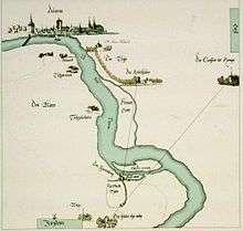
Only in the last few miles of the river's run, near the city of Kampen, distributaries form, resulting in the relatively minor IJssel delta. Some of the branches have been dammed up to lower the risk of flooding; others have silted up. Several of the delta branches are, however, still connected without interruption. Most of the damming-up was done prior to 1932, when the Zuiderzee was turned into the freshwater IJsselmeer lake. The area had been prone to flooding in times of northwestern gales, pushing back the saline Zuiderzee water into the IJssel delta and preventing the water flowing from the mouths of the IJssel branches from discharging into the Zuiderzee.
The modern-day names of the delta branches are, west to east, Keteldiep, Kattendiep, Noorddiep, Ganzendiep and Goot. Of these, the Keteldiep and Kattendiep channels are the main navigational arteries; the Noorddiep has been closed off at both sides. Another branch, De Garste, had already completely silted up by the middle of the nineteenth century.[5] Until the beginning of the twentieth century, the Ganzendiep branch up to the Goot fork was known as IJssel proper.[5] due to it being the historical main channel, with the present-day main channel being called Regtediep or Rechterdiep until well into the twentieth century[6]
The IJssel, although now technically "merely" a Rhine branch, has retained most of the character of a distinct river in its own right, in no small part due to the fact that it has its own tributaries and, in river Oude IJssel, even a former headstream.
Tributaries and connecting canals
The following canals and tributary streams connect to the IJssel, in downstream order:
- Apeldoorns Kanaal (west) near the town of Dieren
- river Oude IJssel (east) at the city of Doesburg
- the Berkel stream (east) at the city of Zutphen
- the Twentekanaal (east) between Zutphen and the village of Eefde (municipality of Gorssel)
- the Schipbeek stream (east) near the city of Deventer
- the Grift stream (west) at the town of Hattem; its lower reaches have been channelised to form the mouth of the Griftkanaal
- the Willemsvaart canal (east) at the city of Zwolle
- the Zwolle-IJsselkanaal (east) near Zwolle
River crossings


Road bridges
Road bridges across river IJssel (with nearest places on the left and right bank):
- Arnhem – Westervoort
- Arnhem – Duiven (A12 motorway)
- Ellecom – Doesburg (N317)
- Brummen – Zutphen (N348)
- Zutphen – Zutphen
- Wilp – Deventer (A1 motorway)
- Deventer – Deventer (N344)
- Hattem – Zwolle
- Hattemerbroek – Zwolle (A28 motorway)
- Kampen – Kampen (N764)
- Kampen – Kampen
- Kampen – Kampereiland (N50)
Railroad bridges
Railroad bridges (with nearest train station on the left and right bank):
- Arnhem Velperpoort – Westervoort
- Brummen/Klarenbeek – Zutphen
- Twello – Deventer
- Wezep/Kampen Zuid – Zwolle
Cable ferries
Only those ferries capable of carrying motorised vehicles are included.
- Dieren – Olburgen
- Brummen – Bronkhorst
- Welsum – Olst
- Vorchten – Wijhe
References
| Wikimedia Commons has media related to IJssel. |
- ↑ J. de Vries, Etymologisch woordenboek. Utrecht: Het Spectrum, 1959
- ↑ Stacey, C. P. History of the Canadian Army in the Second World War: Volume III The Victory Campaign
- ↑ ter Laan, K. et al. ed. (1942). Van Goor's aardrijkskundig woordenboek van Nederland (in Dutch). Den Haag: Van Goor Zonen.
- ↑ Augé, Claude ed. (1922). Larousse universel en deux volumes (in French). Paris: Larousse.
- 1 2 Grote (1990). Grote historische atlas van Nederland (3): Oost-Nederland 1830–1855 (in Dutch). Groningen: Wolters-Noordhoff Atlasprodukties. ISBN 90-01-96232-7.
- ↑ Kwast, B. ed. (1932). Schoolatlas der geheele aarde (in Dutch). Groningen: Wolters.