Hunstrete
| Hunstrete | |
 Hunstrete Green |
|
 Hunstrete |
|
| Population | approx. 100 |
|---|---|
| OS grid reference | ST647624 |
| Unitary authority | Bath and North East Somerset |
| Ceremonial county | Somerset |
| Region | South West |
| Country | England |
| Sovereign state | United Kingdom |
| Post town | BRISTOL |
| Postcode district | BS40 |
| Dialling code | 01761 |
| Police | Avon and Somerset |
| Fire | Avon |
| Ambulance | South Western |
| EU Parliament | South West England |
| UK Parliament | North East Somerset |
Coordinates: 51°21′36″N 2°30′25″W / 51.360°N 2.507°W
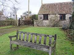
Hunstrete (grid reference ST625643) is a small village on the River Chew in the Chew Valley, Bath and North East Somerset, England. It falls within the civil parish of Marksbury and is 8 miles from Bristol, and Bath, and 5 miles from Keynsham.
History
The origin of the name Hunstrete is unclear. One explanation is that it means 'The hundred road' from the Old English hund and street.[1] Other possible derivations are the personal name hund and Old English steort meaning a projecting piece of land or hund meaning hound or dog relating to the place where they were kept.[2]
Although occupation during the Iron Age is possible the earliest evidence are Roman coins from the emperor Carausius, and continuous occupation during the Saxon period may have been connected with the nearby Wansdyke. A charter of 936 suggests the land was given to a thegn by the name of Ethelelm by Æthelstan. The manor was granted to Glastonbury Abbey who held it until the dissolution of the monasteries in 1539 when it was forfeit to the crown and granted to Richard Watkins. At the beginning of the 17th century it passed to the family of Sir John Popham, whose descendants sold off portions of land in the intervening years but owned Hunstrete House until 1977.[2]
Government and politics
Hunstrete is part of the Farmborough Ward, which is represented by one councillor on the Bath and North East Somerset Unitary Authority, which has responsibilities for services such as education, refuse, tourism etc. The village is a part of North East Somerset,[3] and part of the South West England constituency of the European Parliament.
Demographics
According to the 2001 Census, the Farmborough Ward (which includes Compton Dando, Marksbury, Woollard and Chewton Keynsham), had 1,111 residents, living in 428 households, with an average age of 44.5 years. Of these 71% of residents describing their health as 'good', 21% of 16- to 74-year-olds had no qualifications; and the area had an unemployment rate of 1.0% of all economically active people aged 16–74. In the Index of Multiple Deprivation 2004, it was ranked at 22,100 out of 32,482 wards in England, where 1 was the most deprived LSOA and 32,482 the least deprived.[4]
Hunstrete House
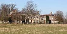
Hunstrete House is a Grade II listed building dating from 1820.[5] In its grounds are Hunstrete Lake, a walled garden[6] and an icehouse which is also a listed building.[7]
In September 2007 a team from the television programme Time Team visited Hunstrete to explore stories about the "Grand Mansion" which preceded the current house. It is thought that Francis Popham, a descendant of Sir John Popham, started the construction of a 17-bay mansion which was, however, abandoned after his death in 1780, and the construction which had taken place was demolished in 1830, leaving just a line of arches. The building material was used in the restoration of Prior Park in Bath.[8] The excavations undertaken tried to identify whether there was a previous medieval or Tudor manor house on the site. The programme was aired on 17 February 2008,[9] and showed that the 1780 mansion was really the addition of a new exterior to a previous building.[10]
Other buildings of note
Other Grade II listed buildings in the area are a pair of mid-nineteenth-century cottages,[11] and a fragment of an arcade from an earlier large house, dating from c.1700.[12]
References
- ↑ Robinson, Stephen (1992). Somerset Place Names. Wimborne, Dorset: The Dovecote Press Ltd. ISBN 1-874336-03-2.
- 1 2 Caola, Susan Elizabeth (2003). Hunstrete: Truth and legend. The Author. ISBN 0-9546239-0-8.
- ↑ "Somerset North East: New Boundaries Calculation". Electoral Calculus: General Election Prediction. Retrieved 19 September 2007.
- ↑ "Neighbourhood Statistics LSOA Bath and North East Somerset 016B Farmborough". Office for National Statistics 2001 Census. Retrieved 1 May 2006.
- ↑ Historic England. "Hunstrete House (32698)". Images of England.
- ↑ "THE PIG is expanding its litter". Retrieved 1 July 2013.
- ↑ Historic England. "Icehouse about 120 metres north of Hunstrete House (32699)". Images of England.
- ↑ "Hunstrete Grand Mansion". Wessex Archeology. Videotext Communications Ltd. Retrieved 10 February 2009.
- ↑ Janes, Rowland (October 2007). "The time team tackles Hunstrete riddle". Chew Valley Gazette.
- ↑ "Hunstrete, Somerset". Time Team. Retrieved 17 February 2008.
- ↑ "Pair of cottages". Images of England. English Heritage. Retrieved 18 March 2009.
- ↑ "Arcade". Images of England. English Heritage. Retrieved 18 March 2009.
External links
| Wikimedia Commons has media related to Hunstrete. |