Hope Island (India)
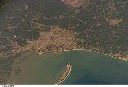 Satellite image of Hope Island and Kakinada coast | |
| Geography | |
|---|---|
| Location | Bay of Bengal |
| Coordinates | 16°58′12″N 82°21′0″E / 16.97000°N 82.35000°ECoordinates: 16°58′12″N 82°21′0″E / 16.97000°N 82.35000°E |
| Adjacent bodies of water | Kakinada Bay |
| Length | 16 km (9.9 mi) |
| Administration | |
|
India | |
| State | Andhra Pradesh |
| District | East Godavari district |
| Additional information | |
| Time zone | |
Hope Island is a small tadpole shaped Island situated off the coast of Kakinada, India, in Bay of Bengal.
Geography
Hope Island is located at 16°58′N 82°21′E / 16.97°N 82.35°E.[1]
A relatively young island, it formed in the last 200 years into a 16-kilometre-long (9.9 mi) sand spit from the sand carried by the waters of Godavari delta.[2]
The area between Kakinada coast and Hope Island is known as Kakinada Bay. The water spread of the bay is about 100 km2 (39 sq mi).
Hope Island protects the city of Kakinada from the strong cyclone/tidal waves/tsunamis coming from the Bay of Bengal. Hope Island acts as a sort of natural break water and provides tranquility to the ships anchored in Kakinada bay which makes Kakinada Port one of the safest natural ports in the Eastern Coast of India.
The northern part of the island is called the "Godavari point" which overlooks the entry point into the Bay of Kakinada and the Kakinada harbour.
Population
Currently the Island houses a small hamlet of fishermen and a few government buildings. Now government is planning to renew this island.