Honnemaradu
Honnemaradu is a tourist place situated on the back waters of River Sharavathi.
Honnemardu derived its name from the Honne tree. However, the literal meaning of Honnemardu is Golden Lake. This is perhaps a reference to the fact that Honnemardu is located on the backwaters of the Sharavathi river.
It is in Sagara taluk, Karnataka about 35 km from Sagara on the way to Jog Falls, 12 km from Talaguppa and 392 km from Bangalore. With reservations, visitors in groups of at least 12 can stay overnight, with facilities for food, shelter and equipment rentals nearby.[1]
Attractions
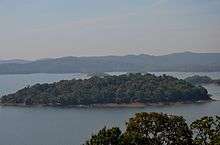
Honnemardu is a small village perched on the hills that overlook the Linganamakki Reservoir. The reservoir is also known as Honnemardu after the village. In the middle of this huge water body there is a small island that attracts campers. In addition to the adventure activities, Honnemardu is a birdwatchers paradise and one can spend endless hours watching and trying to identify the large variety of birds and butterflies. Honnemardu camp is managed by a dedicated team of nature enthusiasts called 'Adventurers'. (The group had its office in Bangalore and to go to Honnemardu we needed to book our seats 2 weeks in advance).[2]
Honnemaradu, a heaven for water sports, is tucked away in the lush greenery of the Western Ghats along the Sharavati backwaters near Sagara. Encompassing an area of 50 km by 80 km, this reservoir stretches as far as the eye can see. Honnemaradu or “Golden Lake” has some of the most spectacular views of the sunrise and sunset.
Deep in the forest, Honnemaradu is a haven for outdoors fanatics as well as those who want a complete break from city life. Trekking, however, is only permitted along roads in a designated area.


Some of the water sports activities here include boating and kayaking, but it only permitted with a guide. Swimming is not allowed. There are no longer equipment for wind rafting.
- Jog Falls is created by the Sharavathi River. The water plummets down from a great height of 289 ft, the highest in India. It’s in Sagara Taluk.
- Dabbe Falls,Sagara: Located 30 km from Jog Falls, Dabbe is another enchanting waterfall in Sagara. This waterfall is hidden in the mountains near Hosagadde.
- Kayakers can plan their next vacation in the hill stations of Karnataka. Kayaking in Honnemaradu is a unique experience, as the kayaks are round and cannot travel very far. Kayaking is permitted only with a guide. The grace the Western Ghats adds to the charm of kayaking in Honnemaradu. Honnemaradu on the back waters of the Sharavathi River.
Transport
Road
- Bangalore-Shimoga-Sagar-Talaguppa-Honnemaradu
- Bellary-Hospet-Harihar-Shimoga-Sagar-Talaguppa-Honnemaradu
Railway station
References
| Wikimedia Commons has media related to Honnemaradu. |
- ↑ "Western Ghats Conservation Society". Retrieved 2011-05-04.
- ↑ "Honnemardu Travel Guide". Retrieved 2011-05-04.
Coordinates: 14°10′41″N 74°52′35″E / 14.178146°N 74.876289°E