Altai Krai
| Altai Krai Алтайский край (Russian) | |||
|---|---|---|---|
| — Krai — | |||
| |||
|
| |||
| |||
|
| |||
| Political status | |||
| Country | Russia | ||
| Federal district | Siberian[2] | ||
| Economic region | West Siberian[3] | ||
| Established | September 28, 1937[4] | ||
| Administrative center | Barnaul | ||
| Government (as of October 2014) | |||
| • Governor[5] | Alexander Karlin[6] | ||
| • Legislature | Altai Krai Legislative Assembly[7] | ||
| Statistics | |||
| Area (as of the 2002 Census)[8] | |||
| • Total | 169,100 km2 (65,300 sq mi) | ||
| Area rank | 22nd | ||
| Population (2010 Census)[9] | |||
| • Total | 2,419,755 | ||
| • Rank | 21st | ||
| • Density[10] | 14.31/km2 (37.1/sq mi) | ||
| • Urban | 54.7% | ||
| • Rural | 45.3% | ||
| Population (January 2014 est.) | |||
| • Total | 2,390,638[11] | ||
| Time zone(s) | KRAT (UTC+07:00)[12] | ||
| ISO 3166-2 | RU-ALT | ||
| License plates | 22 | ||
| Official languages | Russian[13] | ||
| Official website | |||


Altai Krai (Russian: Алта́йский край, tr. Altaysky kray; IPA: [ɐlˈtajskʲɪj kraj]) is a federal subject of Russia (a krai). It borders with, clockwise from the west, Kazakhstan, Novosibirsk and Kemerovo Oblasts, and the Altai Republic. The krai's administrative center is the city of Barnaul. As of the 2010 Census, the population of the krai was 2,419,755.[9]
Geography
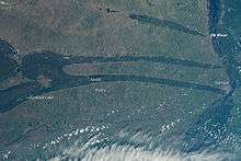
Altai Krai has rolling foothills, grasslands, lakes, rivers, and mountains.[14]
The climate is severe with long cold dry winters and hot, usually dry summers. The region's main waterway is the Ob River. The Biya and Katun Rivers are also important. The biggest lakes are Lake Kulundinskoye, Lake Kuchukskoye, and Lake Mikhaylovskoye.[15]
Altai Krai has huge reserves of raw materials, especially materials used for building, as well as significant mineral reserves. These include nonferrous metals, lead and iron ores, manganese, tungsten, molybdenum, bauxite, and gold. Forests cover about 60,000 km² of the krai's land.[15] See also Geography of South-Central Siberia.
This region of Siberia is extremely important due to its biodiversity, an area of over 1.6 million hectares is recognised by Unesco as a world heritage site and even the endangered snow leopard has made his home there.
The Altai bees (Apis mellifera) are hardy and healthy they are renowned for producing some of the world's finest organic honeys. Historically honey was used by the peoples of Altai and Bashkiria as payment or yasak (levy or tax) to the Russian Tsars.
History
This area is part of a great crossroads in the ancient world.[16] Nomadic tribes crossed through the territory during periods of migration. The nomadic tribes were composed of different peoples. Archeological sites reveal that ancient humans lived in the area.[15] The Altay people are a Turkic people, some of whom have settled here, who were originally nomadic and date back to the 2nd millennium BCE.[17]
The territory of the krai has been controlled by the Xiongnu Empire (209 BC-93 CE) and Mongolian Xianbei state (93-234), Rouran Khaganate (330-555), Mongol Empire (1206-1368), Golden Horde, Northern Yuan (1368-1691) and Zunghar Khanate (1634–1758).[18]
In June 1942 Altai Krai was one of the towns to which women and children and the wives of men deported from Eastern Europe - in particular "Foreigners" / "Other ethnicities" such as Kola Norwegians, Lithuanians & Latvians - by Soviet Russia to hard labor camps were exiled. Ref.Lietuvos žydų tremtinių sąrašas Parengė Galina Žirikova pagal: „Genocido aukų vardynas 1939-1941 m.“ Lietuvos gyventojų genocido ir rezistencijos centras. 1998-2005 m.
Administrative divisions
Heraldry
Flag
The flag of Altai Krai is red and blue with a yellow stripe on it as a symbol of agriculture. In the center of the flag is the coat of arms of Altai Krai.
Coat of arms
The coat of arms of Altai Krai was established in 2000. It includes a shield of French heraldry form with a basement of 8/10th of its height and a sharp part in the middle of the bottom part. Bottom edges of the shield are rounded. The shield is divided with a horizontal stripe into two equal parts. In the upper part has a blue background, which is a symbol of glory, is a steamy oven of the 18th century, which reflects a historical past of the krai. In the bottom part on the red background, which is a symbol of dignity, braveness and courage, is an image of the Koluvan Queen of Vases mainly in green color, which is kept in the Hermitage Museum. The shield is framed with golden wheat ears which represent agriculture as a main industry of Altai Krai.

Politics
During the Soviet period, the high authority in the krai was shared between three persons: The first secretary of the Altai CPSU Committee (who in reality had the most authority), the chairman of the Krai Soviet (legislative power), and the Chairman of the Krai Executive Committee (executive power). Since 1991, CPSU lost all the power, and the head of the krai administration, and eventually the governor was appointed/elected alongside elected regional parliament.
The Charter of Altai Krai is the fundamental law of the region. The Legislative Assembly of Altai Krai is the regional standing legislative (representative) body. The Legislative Assembly exercises its authority by passing laws, resolutions, and other legal acts and by supervising the implementation and observance of the laws and other legal acts passed by it. The highest executive body is the Krai Government, which includes territorial executive bodies such as district administrations, committees, and commissions that facilitate development and run the day to day matters of the province. The Krai Administration supports the activities of the Governor who is the highest official and acts as guarantor of the observance of the krai Charter in accordance with the Constitution of Russia.
On August 7, 2005 the krai's then-head of administration Mikhail Yevdokimov died in a car crash.
Demographics
Population: 2,390,638 (2014 est.);[11] 2,419,755 (2010 Census);[9] 2,607,426 (2002 Census);[19] 2,822,305 (1989 Census).[20]
As of the 2010 Census,[9] Russians form an overwhelming majority of the population, at 94%. Germans are the second-largest group, at about 2% (see Mennonite settlements of Altai). Other groups include Ukrainians (1.4%), Kazakhs (0.3%), Tatars (0.3%), Belarusians (0.2%), Armenians (0.3%), and people of other ethnicities. Additionally, 40,984 people were registered from administrative databases, and could not declare an ethnicity. It is estimated that the proportion of ethnicities in this group is the same as that of the declared group.[21]
- Vital statistics for 2012
2009 - 1.62 | 2010 - 1.63 | 2011 - 1.65 | 2012 - 1.81 | 2013 - 1.83 | 2014 - 1.84 | 2015 - 1.80(e)
Religion

According to a 2012 official survey[25] 22.6% of the population of Altay Krai adheres to the Russian Orthodox Church, 3% are unaffiliated generic Christians, 1% are Orthodox Christian believers without belonging to any church or are adherents of other Orthodox churches, 1% are adherents of Islam. In addition, 31% of the population declares to be "spiritual but not religious", 27% is atheist, and 14.4% follows other religions or did not give an answer to the question.[25]
Sister district
See also
- Altai Mountains
- Sayan Mountains
- Denisova Cave
- List of Chairmen of the Altai Krai Legislative Assembly
References
Notes
- ↑ Article 6 of the Charter of Altai Krai states that the symbols of the krai include a flag and a coat of arm, but there is no provision for an anthem.
- ↑ Президент Российской Федерации. Указ №849 от 13 мая 2000 г. «О полномочном представителе Президента Российской Федерации в федеральном округе». Вступил в силу 13 мая 2000 г. Опубликован: "Собрание законодательства РФ", №20, ст. 2112, 15 мая 2000 г. (President of the Russian Federation. Decree #849 of May 13, 2000 On the Plenipotentiary Representative of the President of the Russian Federation in a Federal District. Effective as of May 13, 2000.).
- ↑ Госстандарт Российской Федерации. №ОК 024-95 27 декабря 1995 г. «Общероссийский классификатор экономических регионов. 2. Экономические районы», в ред. Изменения №5/2001 ОКЭР. (Gosstandart of the Russian Federation. #OK 024-95 December 27, 1995 Russian Classification of Economic Regions. 2. Economic Regions, as amended by the Amendment #5/2001 OKER. ).
- ↑ Resolution of September 28, 1937
- ↑ Charter of Altai Krai, Article 79
- ↑ Official website of Altai Krai. Biography of Alexander Bogdanovich Karlin (Russian)
- ↑ Charter of Altai Krai, Article 67
- ↑ Федеральная служба государственной статистики (Federal State Statistics Service) (2004-05-21). "Территория, число районов, населённых пунктов и сельских администраций по субъектам Российской Федерации (Territory, Number of Districts, Inhabited Localities, and Rural Administration by Federal Subjects of the Russian Federation)". Всероссийская перепись населения 2002 года (All-Russia Population Census of 2002) (in Russian). Federal State Statistics Service. Retrieved 2011-11-01.
- 1 2 3 4 Russian Federal State Statistics Service (2011). "Всероссийская перепись населения 2010 года. Том 1" [2010 All-Russian Population Census, vol. 1]. Всероссийская перепись населения 2010 года (2010 All-Russia Population Census) (in Russian). Federal State Statistics Service. Retrieved June 29, 2012.
- ↑ The density value was calculated by dividing the population reported by the 2010 Census by the area shown in the "Area" field. Please note that this value may not be accurate as the area specified in the infobox is not necessarily reported for the same year as the population.
- 1 2 Altai Krai Territorial Branch of the Federal State Statistics Service. Оценка численности населения на 1 января 2014 года и в среднем за 2013 год (Russian)
- ↑ Правительство Российской Федерации. Федеральный закон №107-ФЗ от 3 июня 2011 г. «Об исчислении времени», в ред. Федерального закона №271-ФЗ от 03 июля 2016 г. «О внесении изменений в Федеральный закон "Об исчислении времени"». Вступил в силу по истечении шестидесяти дней после дня официального опубликования (6 августа 2011 г.). Опубликован: "Российская газета", №120, 6 июня 2011 г. (Government of the Russian Federation. Federal Law #107-FZ of June 31, 2011 On Calculating Time, as amended by the Federal Law #271-FZ of July 03, 2016 On Amending Federal Law "On Calculating Time". Effective as of after sixty days following the day of the official publication.).
- ↑ Official on the whole territory of Russia according to Article 68.1 of the Constitution of Russia.
- ↑ "Russian program — Altai". Archived from the original on March 22, 2007. Retrieved 2006-11-30.
- 1 2 3 "Altai Territory". Archived from the original on November 4, 2006. Retrieved 2006-11-29.
- ↑ "Greater Altai – Altai Krai, Republic of Altai, Tyva (Tuva), and Novosibirsk — Crossroads". Archived from the original on March 14, 2007. Retrieved November 30, 2006.
- ↑ "Peoples from Russia — Alexey, guide in Altay region". Archived from the original on December 30, 2006. Retrieved 2006-11-30.
- ↑ History of Mongolia, Volume II, 2003
- ↑ Russian Federal State Statistics Service (May 21, 2004). "Численность населения России, субъектов Российской Федерации в составе федеральных округов, районов, городских поселений, сельских населённых пунктов – районных центров и сельских населённых пунктов с населением 3 тысячи и более человек" [Population of Russia, Its Federal Districts, Federal Subjects, Districts, Urban Localities, Rural Localities—Administrative Centers, and Rural Localities with Population of Over 3,000] (XLS). Всероссийская перепись населения 2002 года [All-Russia Population Census of 2002] (in Russian). Retrieved August 9, 2014.
- ↑ Demoscope Weekly (1989). "Всесоюзная перепись населения 1989 г. Численность наличного населения союзных и автономных республик, автономных областей и округов, краёв, областей, районов, городских поселений и сёл-райцентров" [All Union Population Census of 1989: Present Population of Union and Autonomous Republics, Autonomous Oblasts and Okrugs, Krais, Oblasts, Districts, Urban Settlements, and Villages Serving as District Administrative Centers]. Всесоюзная перепись населения 1989 года [All-Union Population Census of 1989] (in Russian). Институт демографии Национального исследовательского университета: Высшая школа экономики [Institute of Demography at the National Research University: Higher School of Economics]. Retrieved August 9, 2014.
- ↑ Перепись-2010: русских становится больше. Perepis-2010.ru (2011-12-19). Retrieved on 2013-08-20.
- 1 2 Естественное движение населения в разрезе субъектов Российской Федерации. Gks.ru. Retrieved on 2013-08-20.
- ↑ Естественное движение населения в разрезе субъектов Российской Федерации. Gks.ru. Retrieved on 2013-08-20.
- ↑ Каталог публикаций::Федеральная служба государственной статистики. Gks.ru (2010-05-08). Retrieved on 2013-08-20.
- 1 2 3 Arena - Atlas of Religions and Nationalities in Russia. Sreda.org
- ↑ 2012 Survey Maps. "Ogonek", № 34 (5243), 27/08/2012. Retrieved 24-09-2012.
- ↑ China and Russia sister cities
Sources
- Алтайское краевое Законодательное Собрание. №3-ЗС 5 июня 1995 г. «Устав (основной закон) Алтайского края», в ред. Закона №118-ЗС от 1 декабря 2015 г. «О внесении изменений в Устав (Основной Закон) Алтайского края». Опубликован: "Алтайская правда", №100, 14 июня 1995 г. (Altai Krai Legislative Assembly. #3-ZS June 5, 1995 Charter (Basic Law) of Altai Krai, as amended by the Law #118-ZS of December 1, 2015 On Amending the Charter (Basic Law) of Altai Krai. ).
- Центральный исполнительный комитет СССР. Постановление от 28 сентября 1937 г. «О разделении Западно-Сибирского края на Новосибирскую область и Алтайский край». (Central Executive Committee of the USSR. Resolution of September 28, 1937 On Splitting West Siberian Krai into Novosibirsk Oblast and Altai Krai. ).
External links
| Wikivoyage has a travel guide for Altai Krai. |
| Wikimedia Commons has media related to Altai Krai. |
- Official website of Altai Krai
- Official website of Altai Krai (Russian)
- Kommersant.com. Information about Altai Krai
- Library of Congress Russian (pdf)
- History of Altai Krai
- Altai: a living spirit
| |||||||||||||||||||||||||||||||
| |||||||||||||||||||||||||||||||
 |
|
|
| |
| Pavlodar Province, |
|
| ||
| ||||
| | ||||
| East Kazakhstan Province, |
|