High Bridge Trail State Park
| High Bridge Trail State Park | |
|---|---|
|
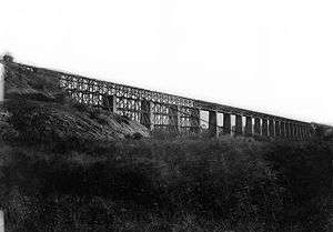
High Bridge at High Bridge Trail State Park | |
 Location of High Bridge Trail State Park | |
| Location | Central and Southside Virginia, United States |
| Nearest city | Farmville, Virginia |
| Coordinates | 37°18′40.61″N 78°19′5.99″W / 37.3112806°N 78.3183306°WCoordinates: 37°18′40.61″N 78°19′5.99″W / 37.3112806°N 78.3183306°W |
| Area | 1,103 acres (446 ha) |
| Established |
2006[1] Completed: 2012[2] |
| Governing body | Virginia Department of Conservation and Recreation |

High Bridge Trail State Park is a rail trail in Southside Virginia converted from a rail line last belonging to Norfolk Southern.
The first section of the High Bridge Trail opened in 2008 and the final section was completed in 2012.[2] With a length of more than thirty miles, the trail is shared by bicyclists, pedestrians and equestrians — and includes a restored crossing at the Appomattox River over the historic High Bridge – from which the park derives its name.
The lineal park traverses Appomattox, Nottoway, Cumberland, and Prince Edward counties as well as Pamplin City, Prospect, Farmville, Rice and Burkeville. Where the trail traverses Farmville, it directly adjoins Longwood University at the campus' satellite housing and athletic site.[3]
Background
High Bridge had been built in 1854 across the Appomattox River connecting Petersburg to Lynchburg. The bridge is 2,400 feet (730 m) long and ranges from 60 to 125 feet (18 to 38 m) high. It was originally made of wood, standing on 20 brick piers and included a pedestrian walkway next to the tracks and a nearby wagon bridge. During the American Civil War, both Union and Confederate forces attempted to destroy the bridge to their advantage. Confederates succeeded in setting the bridge on fire on April 6, 1865, to prevent its crossing by the Union. When Union troops arrived, 3 of the bridge's 21 wooden spans had burned and a 4th span was on fire. Union engineers successfully cut the 4th span to prevent further destruction of the bridge.[4][5] After the Battle of High Bridge and his surrender at Appomattox, Robert E. Lee told the very men who had destroyed the bridge – including civil engineer Major General William Mahone – to go home and start its rebuilding. Engineers began building temporary spans to replace those that had been destroyed; the South Side Rail Road company eventually finished the work and rail traffic resumed in September 1865.[6]
Park history
Norfolk Southern's last train crossed High Bridge on October 26, 2004, and in December 2006 the company donated 31 miles (50 km) of abandoned rail to the Virginia Department of Conservation and Recreation, managers of the Virginia State Park system.[2] Intended as a park with the High Bridge as its centerpiece,[7] the shared-use path for non-motorized traffic – pedestrians, bicyclists, and horseback riders – would preserve and protect trail resources while creating an education resource for local and national history.[8]
With a total budget of an estimated $11 million, four miles of trail east of Farmville opened on Aug. 22, 2008 and 12 more miles from Farmville west to Prospect opened on June 6, 2009. On April 6, 2012, after completion of the final segment of the trail, the restoration of the High Bridge itself, the trail opened for the first time for its full length — 147 years after the Battle of High Bridge.[9]
Park details
Having been privately owned and operated by Norfolk Southern and offering only very limited access, the park area now offers more than thirty miles of white limestone gravel trail open to the public. Retaining the 0.3% grade of the original rail line,[10] the corridor features picnic, parking and toilet facilities as well as large oak trees, telegraph poles erected in the 1900s, remnants of the railroad's signal system, and Norfolk Southern's original cement mile markers.[11] Park rangers and local police monitor the trail daily.
The trail receives community support from the Friends of High Bridge Trail State Park (FoHBTSP). Formed shortly after the creation of the trail, the volunteer group supports the trail with cleaning, publicity and citizen patrol efforts.[12][13]
The High Bridge State Park has added a Mountain Bike Trail System. It is located on the Rochelle tract about 1.5 miles east of the Main Street Access in Farmville. There are two single track loops: the Earley trail, a 1.6 mile blue-blazed beginner loop; and the Burnside Technical Trail, a 2.6 mile red-blazed intermediate/difficult loop.
See also
External links
| Wikimedia Commons has media related to High Bridge Trail State Park. |
- High Bridge Trail State Park Official Site
- Friends of High Bridge Trail State Park (FoHBTSP)
- Interactive Virtual Tour High Bridge State Park
- Trailink
References
- ↑ "History of Virginia State Parks". Virginia.gov. Richmond, VA: Virginia Department of Conservation and Recreation. April 13, 2012. Retrieved April 15, 2012.
- 1 2 3 "High Bridge Trail". Virginia.gov. Richmond, VA: Virginia Department of Conservation and Recreation. April 13, 2012. Retrieved April 15, 2012.
- ↑ "Longwood building two bridges for Lancer Park vehicle and foot traffic". Longwood University Press Release, October 12, 2009.
- ↑ "Burning High Bridge: The South's Last Hope" Historynet.com (Civil War Times magazine, February 13, 2007).
- ↑ Jo D. Smith, A History Of High Bridge (Jo D. Smith, 1987), 8.
- ↑ Bob Flippen and Richard McClintock, High Bridge: "The End of Our Fifteen Months' Labor (Friends of High Bridge Trail State Park, 2014), 13.
- ↑ Recent News Releases dcr.virginia.gov
- ↑ Recreational Planning dcr.virginia.gov
- ↑ "First To Cross". Farmville Herald, April 5, 2012.
- ↑ F. P. Turner, "The Farmville High Bridge across the Appomattox Valley," Engineering News 72, no. 11 (September 10, 1914): 521.
- ↑ "High Bridge Trail Grows 10 Miles". Virginia Bike Federation, May 26, 2009.
- ↑ High Bridge Trail dcr.virginia.gov
- ↑ Friends of High Bridge Trail State Park dcr.virginia.gov