Hemşin
| Hemşin | |
|---|---|
 Hemşin | |
| Coordinates: 41°03′01″N 40°54′06″E / 41.05028°N 40.90167°ECoordinates: 41°03′01″N 40°54′06″E / 41.05028°N 40.90167°E | |
| Country | Turkey |
| Province | Rize |
| Government | |
| • Mayor | Halim Kazım Bekar (AKP) |
| • Kaymakam | Caner Akgün |
| Area[1] | |
| • District | 176.16 km2 (68.02 sq mi) |
| Population (2012)[2] | |
| • Urban | 1,235 |
| • District | 2,022 |
| • District density | 11/km2 (30/sq mi) |
| Post code | 5355x |
| Climate | Cfb |
| Website |
www |
Hemşin (Armenian: Համշէն Hamshen or Համամաշէն Hamamashen, literally "Hamam's Hamlet"; Laz and Georgian: ზუგა Zuga, is a town and district of Rize Province in the Black Sea region of Turkey, 57 km from the city of Rize.
Hemşin is a district of green hills 19 km inland from the Black Sea. The area is the ethnic homeland of the Hemshin peoples of Turkey.
History
As part of the Rize province, Hemshin had been a refuge for some Cimmerians and was a site of early Greek settlements and once part of the Roman Empire and the succeeding Byzantine Empire.
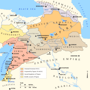
In the 8th century, Prince Hamam, his father Prince Shapuh Amatuni, and their people migrated north to the Black Sea region in order to escape Arab invasions of Vaspurakan. They settled in the ruined city of Tambur and its surrounding villages. Prince Hamam rebuilt the city and named it Hamamshen ("Hamam's hamlet" in Armenian), this becoming the nucleus of the modern district.
This Principality of Hamamshen existed until the 14th century, when it was conquered by the Ottoman Empire.
Demographics
The Hemshin peoples (Armenian: Համշէնցիներ Hamshentsiner; Turkish: Hemşinliler) are a diverse group of peoples who in the past or present have been affiliated with the region.[3][4][5][6]
Climate
Hemşin has an oceanic climate (Köppen: Cfb).
| Climate data for Hemşin | |||||||||||||
|---|---|---|---|---|---|---|---|---|---|---|---|---|---|
| Month | Jan | Feb | Mar | Apr | May | Jun | Jul | Aug | Sep | Oct | Nov | Dec | Year |
| Daily mean °C (°F) | 3.7 (38.7) |
4.4 (39.9) |
6.4 (43.5) |
10.8 (51.4) |
14.6 (58.3) |
18.4 (65.1) |
21.2 (70.2) |
21.3 (70.3) |
18.5 (65.3) |
14.2 (57.6) |
9.9 (49.8) |
6.0 (42.8) |
12.5 (54.5) |
| Average precipitation mm (inches) | 139 (5.47) |
107 (4.21) |
94 (3.7) |
77 (3.03) |
78 (3.07) |
109 (4.29) |
86 (3.39) |
106 (4.17) |
136 (5.35) |
174 (6.85) |
156 (6.14) |
161 (6.34) |
1,423 (56.01) |
| Source: Climate-Data.org[7] | |||||||||||||
See also
References
- ↑ "Area of regions (including lakes), km²". Regional Statistics Database. Turkish Statistical Institute. 2002. Retrieved 2013-03-05.
- ↑ "Population of province/district centers and towns/villages by districts - 2012". Address Based Population Registration System (ABPRS) Database. Turkish Statistical Institute. Retrieved 2013-02-27.
- ↑ Bert Vaux. Hemshinli: The Forgotten Black Sea Armenians. Cambridge: Harvard University, 2001, pp. 1-2, 4-5.
- ↑ Peter Alford Andrews, Ethnic Groups in the Republic of Turkey. Wiesbaden, Dr. Ludwig Reichert Verlag, 1989, pp. 476-477, 483-485, 491.
- ↑ Simonian, Hovann H. "Hemshin from Islamicization to the End of the Nineteenth Century" in The Hemshin: History, society and identity in the Highlands of Northeast Turkey. Hovann H. Simonian (ed.) London: Routledge, 2007, p. 80.
- ↑ Hachikian, Hagop. "Notes on the Historical Geography and Present Territorial Distribution of the Hemshinili", in The Hemshin, pp. 146-147.
- ↑ "Climate: Hemşin". Climate-Data.org. Retrieved 14 April 2014.
External links

Historical states and regions of Armenia | ||
|---|---|---|
| Independent Armenian states |
|  |
| Minor or dependent Armenian states |
| |
| Provinces or Ashkhars of Armenia Major | ||
| Other Armenian regions |
| |
| Other provinces under Tigranes the Great | ||