Hartland, Vermont
| Hartland, Vermont | |
|---|---|
| Town | |
|
Damon Hall, Hartland's town hall | |
 Location in Windsor County and the state of Vermont. | |
 Hartland, Vermont Location in the United States | |
| Coordinates: 43°34′14″N 72°25′21″W / 43.57056°N 72.42250°WCoordinates: 43°34′14″N 72°25′21″W / 43.57056°N 72.42250°W | |
| Country | United States |
| State | Vermont |
| County | Windsor |
| Area | |
| • Total | 45.2 sq mi (117.0 km2) |
| • Land | 45.0 sq mi (116.4 km2) |
| • Water | 0.2 sq mi (0.6 km2) |
| Elevation | 906 ft (276 m) |
| Population (2010) | |
| • Total | 3,393 |
| • Density | 71.7/sq mi (27.7/km2) |
| Time zone | Eastern (EST) (UTC-5) |
| • Summer (DST) | EDT (UTC-4) |
| ZIP code | 05048 |
| Area code(s) | 802 |
| FIPS code | 50-32425[1] |
| GNIS feature ID | 1462117[2] |

Hartland is a town in Windsor County, Vermont, United States. The population was 3,393 at the 2010 census. It includes the villages of Hartland, Hartland Four Corners, and North Hartland.
Geography
According to the United States Census Bureau, the town has a total area of 45.2 square miles (117.0 km2), of which 45.0 square miles (116.4 km2) is land and 0.2 square mile (0.6 km2) (0.53%) is water. The Connecticut River forms its eastern boundary, and the Ottauquechee River flows through the northern part of the town.[3]
Demographics
| Historical population | |||
|---|---|---|---|
| Census | Pop. | %± | |
| 1790 | 1,652 | — | |
| 1800 | 1,960 | 18.6% | |
| 1810 | 2,352 | 20.0% | |
| 1820 | 2,553 | 8.5% | |
| 1830 | 2,503 | −2.0% | |
| 1840 | 2,341 | −6.5% | |
| 1850 | 2,063 | −11.9% | |
| 1860 | 1,748 | −15.3% | |
| 1870 | 1,710 | −2.2% | |
| 1880 | 1,598 | −6.5% | |
| 1890 | 1,393 | −12.8% | |
| 1900 | 1,340 | −3.8% | |
| 1910 | 1,316 | −1.8% | |
| 1920 | 1,212 | −7.9% | |
| 1930 | 1,266 | 4.5% | |
| 1940 | 1,306 | 3.2% | |
| 1950 | 1,559 | 19.4% | |
| 1960 | 1,592 | 2.1% | |
| 1970 | 1,806 | 13.4% | |
| 1980 | 2,396 | 32.7% | |
| 1990 | 2,988 | 24.7% | |
| 2000 | 3,223 | 7.9% | |
| 2010 | 3,393 | 5.3% | |
| Est. 2014 | 3,379 | [4] | −0.4% |
| U.S. Decennial Census[5] | |||
As of the census[1] of 2000, there were 3,223 people, 1,270 households, and 900 families residing in the town. The population density was 71.7 people per square mile (27.7/km2). There were 1,382 housing units at an average density of 30.7 per square mile (11.9/km2). The racial makeup of the town was 98.57% White, 0.12% African American, 0.16% Native American, 0.43% Asian, 0.06% Pacific Islander, 0.06% from other races, and 0.59% from two or more races. Hispanic or Latino of any race were 0.62% of the population.
There were 1,270 households out of which 33.3% had children under the age of 18 living with them, 59.5% were married couples living together, 8.4% had a female householder with no husband present, and 29.1% were non-families. 22.0% of all households were made up of individuals and 6.9% had someone living alone who was 65 years of age or older. The average household size was 2.53 and the average family size was 2.97.
In the town the population was spread out with 26.1% under the age of 18, 5.1% from 18 to 24, 29.2% from 25 to 44, 27.9% from 45 to 64, and 11.8% who were 65 years of age or older. The median age was 40 years. For every 100 females there were 101.2 males. For every 100 females age 18 and over, there were 93.7 males.
The median income for a household in the town was $49,388, and the median income for a family was $55,354. Males had a median income of $32,639 versus $26,691 for females. The per capita income for the town was $23,715. About 1.3% of families and 2.6% of the population were below the poverty line, including 2.7% of those under age 18 and 1.0% of those age 65 or over.
Industry
The town was home to a J. E. Ashworth & Sons blanket mill.[6] Originally the Sturtevant woolen-mills, it was operated by water-power, had five looms, employed twelve men, and made 10,000 blankets per year.[7] The Ottaquechee Woolen Mills in North Hartland had 1,680 spindles, sixty looms, and 75 employees.[8]
Notable people
- Henry M. Bates, Vermont State Treasurer
- Downer T. Bramble, Dakota Territorial legislator
- Roger Enos, veteran of the French and Indian War and American Revolution who commanded the Vermont Militia in the later stages of the American Revolution
- George Seldes, investigative journalist and media critic
- George Tooker, figurative painter in the Magic realism and Social realism movements; recipient of the National Medal of Arts
- Miro Weinberger, current mayor of Burlington, Vermont
- Peter Welch, U.S. Representative
- Daniel Willard, railroad executive
References
- 1 2 "American FactFinder". United States Census Bureau. Retrieved 2008-01-31.
- ↑ "US Board on Geographic Names". United States Geological Survey. 2007-10-25. Retrieved 2008-01-31.
- ↑ DeLorme (1996). Vermont Atlas & Gazetteer. Yarmouth, Maine: DeLorme. ISBN 0-89933-016-9
- ↑ "Annual Estimates of the Resident Population for Incorporated Places: April 1, 2010 to July 1, 2014". Retrieved June 4, 2015.
- ↑ "U.S. Decennial Census". United States Census Bureau. Retrieved May 16, 2015.
- ↑ "Albert P. Ashworth". Times Herald-Record. 1934.
Mr. Ashworth was a member of the firm of J. E. Ashworth's Sons who have been in the blanket business in the place for forty-four years coming here with his parents from Hartland, Vermont.
- ↑ "Hartland". Rootsweb. Retrieved 2008-10-15.
J. E. Ashworth's blanket factory, formerly the Sturtevant woolen-mills, located on road 26, is operated by water-power, has five looms, one set of carriages and jacks, and all necessary machinery for manufacturing horse and army blankets. Mr. Ashworth employs twelve men and manufactures 10,000 blankets per annum.
- ↑ "Hartland". Rootsweb. Retrieved 2014-07-01.
The Ottaquechee Woolen Mills, V. J. BRENNAN, superintendent, located at North Hartland, on the Quechee river, are operated by water-power, have 1,680 spindles, sixty looms, and employs seventy-five hands.
External links
| Wikimedia Commons has media related to Hartland, Vermont. |
- Hartland Vermont Official Town Site
- Hartland Historical Society
- http://www.flickr.com/photos/dougtone/sets/72157624566828463/with/4877062753/
Municipalities and communities of Windsor County, Vermont, United States | ||
|---|---|---|
| Towns | 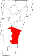 | |
| Villages | ||
| CDPs | ||
| Other communities | ||