Hartford, Vermont
| Hartford, Vermont | |
|---|---|
| Town | |
 Location in Windsor County and the state of Vermont. | |
 Hartford, Vermont Location in the United States | |
| Coordinates: 43°39′54″N 72°22′18″W / 43.66500°N 72.37167°WCoordinates: 43°39′54″N 72°22′18″W / 43.66500°N 72.37167°W | |
| Country | United States |
| State | Vermont |
| County | Windsor |
| Chartered | 1761[1] |
| Area | |
| • Total | 45.9 sq mi (118.9 km2) |
| • Land | 45.0 sq mi (116.5 km2) |
| • Water | 0.9 sq mi (2.3 km2) |
| Elevation | 761 ft (232 m) |
| Population (2010) | |
| • Total | 9,952 |
| • Density | 220/sq mi (84/km2) |
| Time zone | Eastern (EST) (UTC-5) |
| • Summer (DST) | EDT (UTC-4) |
| ZIP code | 05047 |
| Area code(s) | 802 |
| FIPS code | 50-32275[2] |
| GNIS feature ID | 1462116[3] |
| Website |
www |
Hartford is a New England town in Windsor County in the state of Vermont, in the United States. It is located on the New Hampshire border, at the intersection of Interstates 89 and 91. It is the site of the confluence of the White River and the Connecticut River; the Ottauquechee River also flows through the town.[4] The town is composed of five unincorporated villages: Hartford, Quechee, West Hartford, White River Junction and Wilder. The population was 9,952 at the 2010 census.[5]
History
The community was chartered by Governor Benning Wentworth of New Hampshire in 1761,[1] and is named for Hartford, Connecticut.[6][7]
Geography
The town of Hartford is located at 43°39′52″N 72°23′12″W / 43.66444°N 72.38667°W (43.66444, -72.38667).[8]
According to the United States Census Bureau, the town has a total area of 45.9 square miles (118.9 km2), of which 45.0 square miles (116.5 km2) is land and 0.89 square miles (2.3 km2), or 1.93%, is water.[9]
Demographics
| Historical population | |||
|---|---|---|---|
| Census | Pop. | %± | |
| 1790 | 988 | — | |
| 1800 | 1,494 | 51.2% | |
| 1810 | 1,881 | 25.9% | |
| 1820 | 2,010 | 6.9% | |
| 1830 | 2,044 | 1.7% | |
| 1840 | 2,194 | 7.3% | |
| 1850 | 2,159 | −1.6% | |
| 1860 | 2,396 | 11.0% | |
| 1870 | 2,480 | 3.5% | |
| 1880 | 2,954 | 19.1% | |
| 1890 | 3,740 | 26.6% | |
| 1900 | 3,817 | 2.1% | |
| 1910 | 4,197 | 10.0% | |
| 1920 | 4,739 | 12.9% | |
| 1930 | 4,888 | 3.1% | |
| 1940 | 4,978 | 1.8% | |
| 1950 | 5,827 | 17.1% | |
| 1960 | 6,355 | 9.1% | |
| 1970 | 6,477 | 1.9% | |
| 1980 | 7,963 | 22.9% | |
| 1990 | 9,404 | 18.1% | |
| 2000 | 10,367 | 10.2% | |
| 2010 | 9,952 | −4.0% | |
| Est. 2014 | 9,829 | [10] | −1.2% |
| U.S. Decennial Census[11] | |||
As of the census[2] of 2000, there were 10,367 people, 4,509 households, and 2,800 families residing in the town. The population density was 229.6 people per square mile (88.7/km2). There were 5,493 housing units at an average density of 121.7 per square mile (47.0/km2). The racial makeup of the town was 97.02% White, 0.55% African American, 0.31% Native American, 0.88% Asian, 0.03% Pacific Islander, 0.16% from other races, and 1.05% from two or more races. Hispanic or Latino of any race were 0.85% of the population.
There were 4,509 households out of which 28.7% had children under the age of 18 living with them, 48.8% were married couples living together, 10.2% had a female householder with no husband present, and 37.9% were non-families. 30.6% of all households were made up of individuals and 10.9% had someone living alone who was 65 years of age or older. The average household size was 2.28 and the average family size was 2.86.
In the town the population was spread out with 23.4% under the age of 18, 5.9% from 18 to 24, 29.3% from 25 to 44, 26.7% from 45 to 64, and 14.7% who were 65 years of age or older. The median age was 40 years. For every 100 females there were 89.9 males. For every 100 females age 18 and over, there were 86.9 males.
The median income for a household in the town was $42,990, and the median income for a family was $51,286. Males had a median income of $35,969 versus $27,073 for females. The per capita income for the town was $22,792. About 5.3% of families and 8.5% of the population were below the poverty line, including 8.8% of those under age 18 and 4.9% of those age 65 or over.
Notable people
- John L. Bacon, Chelsea and Hartford banker and Vermont State Treasurer[12]
- Daniel A. Dickinson, Minnesota Supreme Court justice[13]
- Albert R. Hall, Minnesota and Wisconsin politician[14]
- Phillips Lord, radio writer and motion picture actor[15]
- William Strong, US congressman[16]
- Andrew Tracy (1797–1868), US congressman[17]
- Joseph Tracy, leading figure in the American Colonization Society
- Horace Wells, dentist and pioneering anesthesiologist
References
- 1 2 "Town of Hartford Vermont". Town of Hartford Vermont. Retrieved October 27, 2012.
- 1 2 "American FactFinder". United States Census Bureau. Retrieved 2008-01-31.
- ↑ "US Board on Geographic Names". United States Geological Survey. 2007-10-25. Retrieved 2008-01-31.
- ↑ DeLorme (1996). Vermont Atlas & Gazetteer. Yarmouth, Maine: DeLorme. ISBN 0-89933-016-9
- ↑ "Profile of General Population and Housing Characteristics: 2010 Demographic Profile Data (DP-1): Hartford town, Windsor County, Vermont". U.S. Census Bureau, American Factfinder. Retrieved July 31, 2012.
- ↑ "Profile for Hartford, Vermont, VT". ePodunk. Retrieved October 27, 2012.
- ↑ Gannett, Henry (1905). The Origin of Certain Place Names in the United States. Govt. Print. Off. p. 151.
- ↑ "US Gazetteer files: 2010, 2000, and 1990". United States Census Bureau. 2011-02-12. Retrieved 2011-04-23.
- ↑ "Geographic Identifiers: 2010 Demographic Profile Data (G001): Hartford town, Windsor County, Vermont". U.S. Census Bureau, American Factfinder. Retrieved July 31, 2012.
- ↑ "Annual Estimates of the Resident Population for Incorporated Places: April 1, 2010 to July 1, 2014". Retrieved June 4, 2015.
- ↑ "U.S. Decennial Census". United States Census Bureau. Retrieved May 16, 2015.
- ↑ Hiram Carleton, Genealogical and Family History of the State of Vermont, 1903, pages 216-217
- ↑ Minnesota State Law Library-Daniel A. Dickinson
- ↑ The Blue Book of the State of Wisconsin. 1893. p. 640.
- ↑ "Phillips Lord". IMDb. Retrieved October 27, 2012.
- ↑ "STRONG, William, (1763 - 1840)". Biographical Directory of the United States Congress. Retrieved October 27, 2012.
- ↑ "TRACY, Andrew, (1797 - 1868)". Biographical Directory of the United States Congress. Retrieved October 27, 2012.
External links
| Wikimedia Commons has media related to Hartford, Vermont. |
- Town of Hartford official website
- Hartford Area Chamber of Commerce
- Hartford Historical Society
- City-Data.com
- ePodunk: Profile for Hartford, Vermont
Municipalities and communities of Windsor County, Vermont, United States | ||
|---|---|---|
| Towns | 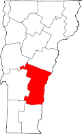 | |
| Villages | ||
| CDPs | ||
| Other communities | ||