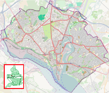
Harefield, Southampton
| Harefield | |
 Cheriton Avenue, Harefield |
|
 Harefield |
|
| Area | 2.62 km2 (1.01 sq mi) |
|---|---|
| Population | 14,035 [1] |
| – density | 5,357/km2 (13,870/sq mi) |
| Unitary authority | Southampton |
| Ceremonial county | Hampshire |
| Region | South East |
| Country | England |
| Sovereign state | United Kingdom |
| Post town | SOUTHAMPTON |
| Postcode district | SO18 |
| Dialling code | 023 |
| Police | Hampshire |
| Fire | Hampshire |
| Ambulance | South Central |
| EU Parliament | South East England |
| UK Parliament | Southampton Itchen |
Coordinates: 50°55′08″N 1°20′34″W / 50.9188°N 1.3427°W
Harefield is a suburb and Electoral Ward near Bitterne in Southampton, England. The entire suburb consists of a council housing estate built around 1952/3 on the 238-acre (0.96 km2) estate of Harefield House.
Harefield Ward had a population of 14,035 at the 2011 Census,[1] and is adjacent to Bitterne Park, Peartree, Sholing and Bitterne wards.
History
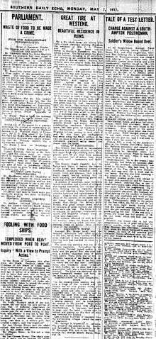
Harefield House was a country house of Elizabethan style built in 1834 for Sir Edward Butler, chairman of the Southampton and Salisbury Railway Company, in what are now the grounds of Harefield Infant and Junior Schools on Yeovil Chase. Edwin Jones, the Southampton draper whose store ultimately became part of Debenhams bought the house in 1887. Harefield House is often mistakenly reported as burning down in 1915, this misconception is printed in the book Memories of Bitterne by Irene Pilson and seems to of stuck. The house actually burnt down on the 6th of May 1917 as seen in the article GREAT FIRE IN WESTEND.[2] The Jones family sold the estate in 1917 and there was some building in the 1920s but it was not developed in earnest until after the Second World War.
The area was part of the civil parish of West End when it was established in 1894, but was transferred into Southampton in 1954.[3]
The street names on the western edge of the estate are all named after Somerset place names by the private housing developers active in the late 1940s and early 1950s. The later council housing extended these streets and added more to the west that are named after Hampshire villages.
The development of the housing estate included two public houses (the Exford Arms and the Hare and Hounds), two shopping parades, two primary schools (Harefield and Moorhill, each consisting of infant and junior schools), and Moorhill Secondary School (named after Moorhill House, which stood just outside the estate in West End). The Moorhill schools and the Exford Avenue shopping parade were constructed in 1964-65. Until that time there was a Post Office in a Nissen hut opposite the Exford Arms.
Moorhill Secondary School was renamed as Woodlands Community School in 1984, and subsequently demolished and rebuilt in 2003. It is now known as Woodlands Community College.
Transport links
Harefield has had a number of different local bus services over the years. It now only has the number 13 First Bus service that goes to Bitterne, Woolston and the City Centre with no bus service on Sundays.
References
- Jessica Vale. The Country Houses of Southampton.
- 1 2 "Harefield (Ward) — Key Figures for 2001 Census: Key Statistics" (PDF). Office for National Statistics. 2011. Retrieved 2015-07-11.
- ↑
- ↑ West End Local History Society: Brief History of West End
Areas and suburbs of Southampton | |||||||||
|---|---|---|---|---|---|---|---|---|---|
| |||||||||
| Southampton Itchen |
| ||||||||
| Southampton Test | |||||||||
| Romsey and Southampton North | |||||||||
| |||||||||