Hajdú-Bihar County
| Hajdú-Bihar County | |||
|---|---|---|---|
   | |||
| |||
 | |||
| Country | Hungary | ||
| Region | Northern Great Plain | ||
| County seat | Debrecen | ||
| Government | |||
| • President of the General Assembly | Zoltán Pajna (Fidesz-KDNP) | ||
| Area | |||
| • Total | 6,210.51 km2 (2,397.89 sq mi) | ||
| Area rank | 4th in Hungary | ||
| Population (2011 census) | |||
| • Total | 546,721 | ||
| • Rank | 4th in Hungary | ||
| • Density | 88/km2 (230/sq mi) | ||
| Postal code | 40xx – 422x, 4241 – 4243, 425x – 429x | ||
| Area code(s) | (+36) 52, 54 | ||
| ISO 3166 code | HU-HB | ||
| Website |
www | ||

Hajdú-Bihar (Hungarian: Hajdú-Bihar megye) is an administrative county (comitatus or megye) in eastern Hungary, on the border with Romania. It shares borders with the Hungarian counties Szabolcs-Szatmár-Bereg, Borsod-Abaúj-Zemplén, Jász-Nagykun-Szolnok and Békés. The capital of Hajdú-Bihar county is Debrecen. Together with Bihor County in Romania it constitutes the Biharia Euroregion.
Geography
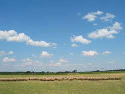
The area of the county does not form a geographical unit; it shares several features with the neighbouring areas: from northeast the sand hills of the Nyírség spread over the county borders. The western part is the Hortobágy National Park ("Puszta"), a large flat area of the country.
The county of Hajdú-Bihar occupies the eastern part of Hungary. Most of its territory is completely flat and is part of the Pannonian Plain region (called the Grand Plain in the country). The highest point hardly rises over 170.5 metres in the north. It seems that the county slopes to the south because the lowest point is situated in this part of Hajdú-Bihar and hits the 85 metres height.
The wind and rivers formed and shaped the land for thousands of years. First the area of the present-day Hungary was occupied by an inland sea. Then, after some underground movement, the huge peaks of the Carpathians rose from this sea. The wild and rapid rivers of the mountains slowly made that inland sea disappear. Later, the great Hungarian plain was formed by the alluvial deposits of the rivers, the wind began to work and from the great rocks became smaller and smaller sand-grains, the so-called loess. This covers thickly the Hajdú-Bihar plain as well and makes a fertile soil.
There are two great rivers in this area, the Tisza and the Körös. The Hortobágy area was formed by the first one. It used to be the flood area of the Tisza river and after the river was controlled, the Hortobágy became dry, resulting in special fauna.
History
Hajdú-Bihar county was created after World War II from the pre-1938 counties Hajdú and Bihar. See the articles of those counties for the history before World War II.
Demographics
In 2015, it had a population of 537,268 and the population density was 87/km².
| Year | County population[1] | Change |
|---|---|---|
| 1949 | 498,271 | n/a |
| 1960 | 4.92% | |
| 1970 | 0.41% | |
| 1980 | 5.05% | |
| 1990 | -0.49% | |
| 2001 | 0.78% | |
| 2011 | -1.34% |
Ethnicity
Besides the Hungarian majority, the main minorities are the Roma (approx. 18,000), Romanians (2,000) and Germans (1,000).
Total population (2011 census): 546,721
Ethnic groups (2011 census):[2]
Identified themselves: 485 877 persons:
- Hungarians: 461 809 (95,05%)
- Gypsies: 18 132 (3,73%)
- Others and indefinable: 5 936 (1,22%)
Approx. 77,000 persons in Hajdú-Bihar County did not declare their ethnic group at the 2011 census.
Religion
Religious adherence in the county according to 2011 census:[3]
- Reformed – 29.0%;
- Catholic – 15.7% (Roman Catholic – 9.8%; Greek Catholic – 5.9%);
- Evangelical – 0.2%;
- Orthodox – 0.2%
- other religions – 1.9%;
- Non-religious – 26.9%;
- Atheism – 1.2%;
- Undeclared – 25.0%.
Regional structure
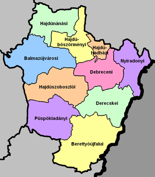
| № | English and Hungarian names |
Area (km²) |
Population (2011) |
Density (pop./km²) |
Seat | № of municipalities |
| 1 | Balmazújváros District Balmazújvárosi járás |
827.45 | 30,091 | 36 | Balmazújváros | 5 |
| 2 | Berettyóújfalu District Berettyóújfalui járás |
1,073.90 | 44,995 | 42 | Berettyóújfalu | 25 |
| 3 | Debrecen District Debreceni járás |
531.12 | 224,228 | 423 | Debrecen | 2 |
| 4 | Derecske District Derecskei járás |
650.30 | 41,701 | 64 | Derecske | 13 |
| 5 | Hajdúböszörmény District Hajdúböszörményi járás |
471.43 | 40,568 | 86 | Hajdúböszörmény | 2 |
| 6 | Hajdúhadház District Hajdúhadházi járás |
137.02 | 22,183 | 162 | Hajdúhadház | 3 |
| 7 | Hajdúnánás District Hajdúnánási járás |
547.27 | 29,614 | 54 | Hajdúnánás | 6 |
| 8 | Hajdúszoboszló District Hajdúszoboszlói járás |
732.65 | 43,061 | 59 | Hajdúszoboszló | 5 |
| 9 | Nyíradony District Nyíradonyi járás |
510.28 | 29,534 | 58 | Nyíradony | 9 |
| 10 | Püspökladány District Püspökladányi járás |
729.04 | 40,426 | 55 | Püspökladány | 12 |
| Hajdú-Bihar County | 6,210.51 | 546,721 | 88 | Debrecen | 82 | |
Economy
Infrastructure
Highways no. 4, 33, 35, 42 and 47 lead to the county and the county can also be reached Hajdú-Bihar via the M3 motorway (this motorway is now a spur to Debrecen). The total length of the public roads in the county is 1,511 km. 122 road bridges span the rivers and canals. The roads cross the national borders to Romania at the cities of Ártánd and Nyírábrány.
Politics
The Hajdú-Bihar County Council, elected at the 2014 local government elections, is made up of 24 counselors, with the following party composition:[4]
| Party | Seats | Current County Assembly | ||||||||||||||
|---|---|---|---|---|---|---|---|---|---|---|---|---|---|---|---|---|
| Fidesz-KDNP | 14 | |||||||||||||||
| Movement for a Better Hungary (Jobbik) | 6 | |||||||||||||||
| Hungarian Socialist Party (MSZP) | 3 | |||||||||||||||
| Democratic Coalition (DK) | 1 | |||||||||||||||
Municipalities
Compared to the average, Hajdú-Bihar has a small number of inhabited places: 19 towns and 62 villages. The four largest cities – both by area and by population – are Debrecen, Hajdúböszörmény, Hajdúnánás and Hajdúszoboszló. For a long time these were the only ones with city/town status, the rest were only villages, but after 1979 – when Berettyóújfalu became a town – several villages were promoted.
Hajdú-Bihar County has 1 city with county rights (megyei jogú város), 20 towns (város), 10 large villages (nagyközség) and 51 villages (falu):
City with county rights
- Debrecen – county seat; 211,320 (as of 2011)
Towns
(ordered by population, as of 2011 census)
- Hajdúböszörmény (31,725)
- Hajdúszoboszló (23,933)
- Balmazújváros (17,537)
- Hajdúnánás (17,063)
- Berettyóújfalu (15,472)
- Püspökladány (14,895)
- Hajdúsámson (13,121)
- Hajdúhadház (12,588)
- Derecske (8,922)
- Nádudvar (8,853)
- Hajdúdorog (8,843)
- Polgár (8,098)
- Nyíradony (7,585)
- Létavértes (6,966)
- Téglás (6,432)
- Kaba (5,960)
- Komádi (5,421)
- Vámospércs (5,362)
- Tiszacsege (4,713)
- Biharkeresztes (4,149)
Villages
- Álmosd
- Ártánd
- Bakonszeg
- Bagamér

- Báránd
- Bedő
- Berekböszörmény
- Bihardancsháza
- Biharnagybajom
- Bihartorda
- Bocskaikert
- Bojt
- Csökmő
- Darvas
- Ebes
- Egyek
- Esztár
- Folyás
- Földes
- Furta
- Fülöp
- Gáborján
- Görbeháza
- Hajdúbagos
- Hajdúszovát
- Hencida
- Hortobágy
- Hosszúpályi
- Kismarja
- Kokad
- Konyár
- Körösszakál
- Körösszegapáti
- Magyarhomorog
- Mezőpeterd
- Mezősas
- Mikepércs
- Monostorpályi
- Nagyhegyes
- Nagykereki
- Nagyrábé
- Nyíracsád
- Nyírábrány
- Nyírmártonfalva
- Pocsaj
- Sáp
- Sáránd
- Sárrétudvari
- Szentpéterszeg
- Szerep
- Tépe
- Tetétlen
- Tiszagyulaháza
- Told
- Újiráz
- Újléta
- Újszentmargita
- Újtikos
- Váncsod
- Vekerd
- Zsáka
![]() municipalities are large villages.
municipalities are large villages.
Gallery
_12.jpg) Debrecen, the Calvinist Rome
Debrecen, the Calvinist Rome
.jpg) Bocskai Mansion, Nagykereki
Bocskai Mansion, Nagykereki.jpg)
_2.jpg) Traditional house in Biharnagybajom
Traditional house in Biharnagybajom
International relations
Hajdú-Bihar County has a partnership relationship with:[5][6]
|
|
References
- ↑ népesség.com, "Hajdú-Bihar megye népessége 1870-2015"
- ↑ 1.1.6. A népesség anyanyelv, nemzetiség és nemek szerint – Frissítve: 2013.04.17.; Hungarian Central Statistical Office (Hungarian)
- ↑ 2011. ÉVI NÉPSZÁMLÁLÁS, 3. Területi adatok, 3.9 Hajdú-Bihar megye, (Hungarian)
- ↑ Közgyűlési tagok, (Hungarian)
- ↑ Nemzetközi kapcsolataink (Hajú-Bihar)
- ↑
External links
| Wikimedia Commons has media related to Hajdú-Bihar County. |
- Official site in Hungarian
- Hajdú Online (haon.hu) - The county portal
- (Hungarian) Restaurants, bars, pubs, gastro-articles, daily menus from Hajdú-Bihar
County seat: Debrecen | ||
| Cities and towns | | |
| Villages |
| |
| Other topics |
| |
Coordinates: 47°25′N 21°30′E / 47.417°N 21.500°E