Haines, Alaska
| Haines, Alaska | |
|---|---|
| CDP | |
|
Haines, viewed from Mount Ripinski, with Chilkoot Inlet on the left, Chilkat Inlet on the right, and the Chilkat Peninsula extending into the distance. | |
| Motto: The Adventure Capital of Alaska | |
 Location of Haines, Alaska | |
| Coordinates: 59°14′2″N 135°26′49″W / 59.23389°N 135.44694°WCoordinates: 59°14′2″N 135°26′49″W / 59.23389°N 135.44694°W | |
| Country | United States |
| State | Alaska |
| Borough | Haines |
| Incorporated | January 24, 1910 |
| Disincorporated | October 17, 2002 (consolidated with a reincorporated Haines Borough) |
| Government | |
| • Borough mayor | Janice Hill[1] |
| • State senator | Dennis Egan (D) |
| • State rep. | Sam Kito III (D) |
| Area | |
| • Total | 21.5 sq mi (55.8 km2) |
| • Land | 13.5 sq mi (35 km2) |
| • Water | 8 sq mi (20.8 km2) |
| Elevation | 36 ft (11 m) |
| Population (2000) | |
| • Total | 1,811 |
| Time zone | Alaska (AKST) (UTC-9) |
| • Summer (DST) | AKDT (UTC-8) |
| ZIP code | 99827 |
| Area code | 907 |
| FIPS code | 02-31050 |
| GNIS feature ID | 1422400 |
| Website | haines.ak.us |

Haines (Tlingit: Deishú) is a census-designated place located in Haines Borough, Alaska, United States. It is in the northern part of the Alaska Panhandle, near Glacier Bay National Park and Preserve.
As of the 2010 census, the population of the area was 2,508.
History

The area around present-day Haines was called "'Dtehshuh" or "end of the trail" by the Chilkat group of Tlingit. It received this name because they could portage (carry) their canoes from the trail they used to trade with the interior, which began at the outlet of the Chilkat River, to Dtehshuh and save 32 km (20 mi) of rowing around the Chilkat Peninsula.
The first European, George Dickinson, an agent for the North West Trading Company, settled at Dtehshuh in 1880. In 1881, the Chilkat asked Sheldon Jackson to send missionaries to the area. Samuel Hall Young, a Presbyterian minister, was sent. He built the Willard mission and school at Dtehshuh, on land given the church by the Chilkat. The mission was renamed Haines in 1884 in honor of Frances Electra Haines, the chairwoman of the committee that raised funds for its construction.
At the time the boundary between Canada and the U.S. was disputed and vaguely defined. There were overlapping land claims from the United States' purchase of Alaska from Russia in 1867 and British claims along the coast. Canada had requested a survey after British Columbia united with it in 1871, but the idea was rejected by the United States as being too costly given the area's remoteness, sparse settlement, and limited economic or strategic interest.
The Klondike Gold Rush of 1898–1899 changed the region greatly. The population of the area reached 30,000, composed largely of Americans. Haines grew as a supply center, since the Dalton Trail from Chilkat Inlet offered a route to the Yukon for prospectors. Gold was also discovered 36 miles (58 km) from Haines in 1899 at the Porcupine District. During this time the name Haines came into use for the area around the mission and not for just the mission itself.
The sudden importance of the region increased the urgency of fixing an exact boundary. There were reports that Canadian citizens were harassed by the U.S. as a deterrent to making any land claims. In 1898 the national governments agreed on a compromise, but the government of British Columbia rejected it. U.S. President McKinley proposed a permanent lease of a port near Haines, but Canada rejected that compromise.
The economy continued to grow and diversify. Four canneries were constructed around the mission by 1900. However, the completion of the White Pass and Yukon Route railway in neighboring Skagway that same year led to the Dalton Trail's eventual abandonment and Haines' economic decline.
In 1903, the Hay-Herbert Treaty entrusted the border decision to arbitration by a mixed tribunal of six members, three American and three Canadian–British, who determined in favor of the United States, resulting in the present-day border.
Fort William H. Seward, a United States Army installation, was constructed south of Haines in 1904, on property donated by the mission from its holdings. In 1922, the fort was renamed Chilkoot Barracks. It was the only United States Army post in Alaska before World War II. During World War II, it was used as a supply point for some U. S. Army activities in Alaska. The fort was deactivated in 1946 and sold as surplus property to a group of investors (Ted Gregg, Carl Heinmiller, Marty Cordes, Clarence Mattson, and Steve Homer) who called it Port Chilkoot, thus forming the Port Chilkoot Company. Port Chilkoot was incorporated as a city in 1956. In 1970, Port Chilkoot merged with Haines into one municipality. Heinmiller was Port Chilkoot's mayor for the majority of its existence as a separate city. In 1972, the fort was designated a National Historic Landmark and the name, Fort William H. Seward, was restored.
Haines was the southern terminal of the Haines-Fairbanks Pipeline (not connected or related to the Trans-Alaska Pipeline System), which provided refined petroleum products to Fort Greely, Eielson Air Force Base, and Ladd Air Force Base (transferred to the Army as Fort Wainwright in 1961). This 626 miles (1,007 km), 8-inch (200 mm) pipeline carried diesel, automotive gas, jet fuel and aviation gas from Haines to Fairbanks from 1955 until it was retired by the US Army in 1973, due to deterioration and prohibitive repair costs. A US Army facility with storage tanks existed alongside the Haines Terminal, which was maintained by the US Army for another decade. The construction and maintenance of the terminal and storage facility were a significant factor in the Haines economy for four decades.[2]
The last of the four canneries closed in 1972 due to declining fish stocks, though commercial fishing (both trolling and gillnetting) remains an important part of the local economy. Logging and sawing timber has been an industry around Haines but has declined also in recent years.
In October 2002, voters approved a measure consolidating the city of Haines and Haines Borough into a home rule borough.[3]
Geography and climate
Haines is located at 59°14′02″N 135°26′49″W / 59.233800°N 135.447009°W.[4] According to the United States Census Bureau, the city has a total area of 21.5 square miles (56 km2), of which 13.5 sq mi (35 km2) is land and 8.0 sq mi (21 km2) (37.26%) is water.
Because of its location in the Alaska Panhandle, Haines has an hemiboreal continental (Köppen Dfb) climate, with Oceanic characteristics. Winters are mild by Alaskan standards, with an average January high temperature around 30 °F (−1 °C), and the average low around 20 °F (−7 °C). Summers are cool to mild, with an average July high temperature of 65 °F (18 °C), and an average low temperature of 51 °F (11 °C). Various days in the summer surpass 25 °C (77 °F). The highest recorded temperature in Haines is 98 °F (37 °C) on July 31, 1976. The record low temperature in the city is −15 °F (−26 °C) on February 20, 1994.
During the 21st century, Haines has twice set a local record for snowfall: for the 2006−2007 season it received 309 inches (7.8 m) of snow, a record broken during the 2011−2012 season, when it received 360 inches (9.1 m).[5]
| Climate data for Haines, Alaska | |||||||||||||
|---|---|---|---|---|---|---|---|---|---|---|---|---|---|
| Month | Jan | Feb | Mar | Apr | May | Jun | Jul | Aug | Sep | Oct | Nov | Dec | Year |
| Record high °F (°C) | 57 (14) |
53 (12) |
63 (17) |
75 (24) |
84 (29) |
92 (33) |
98 (37) |
95 (35) |
86 (30) |
65 (18) |
65 (18) |
61 (16) |
98 (37) |
| Average high °F (°C) | 29.8 (−1.2) |
33.5 (0.8) |
39.0 (3.9) |
48.8 (9.3) |
57.6 (14.2) |
63.6 (17.6) |
65.3 (18.5) |
64.7 (18.2) |
57.2 (14) |
47.4 (8.6) |
35.8 (2.1) |
31.4 (−0.3) |
47.84 (8.81) |
| Average low °F (°C) | 19.6 (−6.9) |
22.8 (−5.1) |
26.7 (−2.9) |
34.1 (1.2) |
41.9 (5.5) |
48.6 (9.2) |
51.3 (10.7) |
49.7 (9.8) |
44.4 (6.9) |
37.2 (2.9) |
26.1 (−3.3) |
22.2 (−5.4) |
35.38 (1.88) |
| Record low °F (°C) | −18 (−28) |
−16 (−27) |
−7 (−22) |
6 (−14) |
26 (−3) |
36 (2) |
40 (4) |
35 (2) |
24 (−4) |
6 (−14) |
−11 (−24) |
−14 (−26) |
−16 (−27) |
| Average precipitation inches (mm) | 5.08 (129) |
4.08 (103.6) |
3.18 (80.8) |
2.42 (61.5) |
1.46 (37.1) |
1.47 (37.3) |
1.53 (38.9) |
2.58 (65.5) |
5.46 (138.7) |
8.46 (214.9) |
6.10 (154.9) |
5.73 (145.5) |
47.55 (1,207.7) |
| Average snowfall inches (cm) | 30.5 (77.5) |
27.2 (69.1) |
8.9 (22.6) |
2.2 (5.6) |
0.1 (0.3) |
0 (0) |
0 (0) |
0 (0) |
0.2 (0.5) |
2.2 (5.6) |
22.1 (56.1) |
28.3 (71.9) |
121.7 (309.2) |
| Average precipitation days (≥ 0.01 in) | 17 | 14 | 14 | 11 | 9 | 9 | 12 | 13 | 17 | 21 | 18 | 18 | 173 |
| Source #1: WRCC [6] | |||||||||||||
| Source #2: WRCC [7] | |||||||||||||
Demographics
| Historical population | |||
|---|---|---|---|
| Census | Pop. | %± | |
| 1900 | 85 | — | |
| 1910 | 446 | 424.7% | |
| 1920 | 314 | −29.6% | |
| 1930 | 344 | 9.6% | |
| 1940 | 357 | 3.8% | |
| 1950 | 338 | −5.3% | |
| 1960 | 392 | 16.0% | |
| 1970 | 463 | 18.1% | |
| 1980 | 993 | 114.5% | |
| 1990 | 1,238 | 24.7% | |
| 2000 | 1,811 | 46.3% | |
| 2010 | 2,508 | 38.5% | |
| source:[8] | |||
2000 Census

As of the census[9] of 2000, there were 1,811 people, 752 households, and 505 families residing in the city. The population density was 134.0 people per square mile (51.7/km²). There were 895 housing units at an average density of 66.2 per square mile (25.6/km²). The racial makeup of the city was 79.62% White, 13.86% Native American, 0.66% Asian, 0.17% Black or African American, 0.11% Pacific Islander, 0.44% from other races, and 5.14% from two or more races. 1.55% of the population were Hispanic or Latino of any race.
There were 752 households out of which 33.4% had children under the age of 18 living with them, 53.9% were married couples living together, 8.9% had a female householder with no husband present, and 32.8% were non-families. 27.5% of all households were made up of individuals and 8.2% had someone living alone who was 65 years of age or older. The average household size was 2.40 and the average family size was 2.94.
In the city the age distribution of the population shows 26.7% under the age of 18, 5.3% from 18 to 24, 28.0% from 25 to 44, 28.4% from 45 to 64, and 11.6% who were 65 years of age or older. The median age was 40 years. For every 100 females age 18 and over, there were 99.7 males.
The median income for a household in the city was $39,926, and the median income for a family was $51,316. Males had a median income of $41,103 versus $30,278 for females. The per capita income for the city was $22,505. About 5.8% of families and 7.9% of the population were below the poverty line, including 9.2% of those under age 18 and 2.4% of those age 65 or over.
Attractions

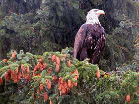
Many tourists visit during the annual appearance of bald eagles in the Alaska Chilkat Bald Eagle Preserve between October and February. During this time, Haines has the largest concentration of bald eagles in the world.[10]
The community and surrounding area is also extremely popular for outdoor recreation. Rafting in the Chilkat River and hiking in the Takshanuk Mountains (Mount Ripinski and other peaks) are both popular. Growing winter recreational opportunities are available at and around Chilkat Pass for which Haines serves as a gateway with the Haines Highway. In recent years, Haines has received increasing attention as a site for heli-skiing. The Davidson Glacier, due to its relatively accessible nature, is also a popular attraction.
Lutak Inlet and Chilkoot Lake are easily accessible and popular fishing sites. Lutak Inlet is frequented by numerous sea lions, seals, and orcas.
Fort William H. Seward is a nationally recognized historic site (declared National Historic Landmark in 1978), where a number of barracks, officer housing, and parade grounds are maintained, in private ownership today. Some of these structures are open to the public as businesses and restaurants. The Fort is within Haines city limits, and is also referred to as Port Chilkoot, a leftover from the Port Chilkoot Company, which was formed after World War II by a group of investors who purchased the Fort from the Federal Government.
Haines also has a number of cultural offerings. Alaska Indian Arts [11] offers demonstrations by traditional craftsmen. History of the town of Haines and the local Tlingit people are featured in the Sheldon Museum & Cultural Center.[12] The Hammer Museum [13] is dedicated to the history of the hammer in human society. The Tsirku Canning Company Museum offers a glimpse of Haines' historic salmon canneries.
Haines is the location for the Southeast Alaskan State Fair, held annually each July. Among other attractions, the fairgrounds incorporate a portion of the set from Walt Disney's White Fang film, filmed in Haines in 1990. The surviving set includes a dozen small structures common to a mining town of the period of Jack London's book of the same name.[14]
Tourists also visit annually on cruise ships.
Education
Haines is home to the Haines Borough Public Library and also the Haines Borough School District, include Haines Elementary School and Haines High School. Some students from Haines also choose to attend Klukwan High School of the Chatham School District.
Transportation
Haines is much more accessible than most other southeast Alaskan communities of its size, as it is connected to the North American highway system by the Haines Highway, which passes through British Columbia on its way to the junction with the Alaska Highway at Haines Junction, Yukon. However, snow and ice conditions in the winter and the long driving times can often make this route less feasible, and at times results in closure of the portion of the highway in the Chilkat Pass, just past the Canada–US border. Haines is one of only three cities in Southeast Alaska which are accessible by road to another city: Skagway is another and the third is Hyder.
The primary mode of intra-Alaskan transportation is by the Alaska Marine Highway. The Lynn Canal route of the ferry system (Juneau-Haines-Skagway) is the only profitable route in the entire system and often receives a large amount of ferry traffic, especially in the summer.
The Haines Airport also receives a large amount of traffic, with three bush carriers serving it with services to Gustavus, Skagway and Sikta Juneau: Alaska Seaplanes and Wings of Alaska and Harris Aircraft Services, Inc..
Recently, Haines became a port-of-call to several cruise ship operators, including Princess Cruises and the Holland-America Line. As of summer 2009, the cruise ship visiting frequency is about 18 per season, according to local residents. The cruise ship berth is very near Fort William H. Seward.
Health care
Haines is served by Haines Health Center, the only primary health clinic in the area. The facility is part of the Southeast Alaska Regional Health Consortium, or SEARHC, a non-profit tribal health consortium of 18 Native communities. The center is open daily Monday through Friday year round, and also provides urgent care after hours. The area is also served 24/7 by local EMS. Individuals in need of dire medical attention are transported by air via helicopter or air ambulance to Bartlett Regional Hospital in Juneau (an approximately 35 minute flight). Whitehorse General Hospital in Whitehorse, Yukon is the nearest hospital to Haines that is accessible by road (an approximately 4 hour and 30 minute drive).
Media
Haines is served by a weekly newspaper, the Chilkat Valley News,[15] as well as the public radio station KHNS which serves upper Lynn Canal (Haines, Skagway, and Klukwan) although its primary studios are located in Haines. Haines also receives circulation of the free regional newspaper Capital City Weekly.
Notable residents
- Jennie Thlunaut, Tlingit master weaver
- Bill Thomas, commercial fisherman and former member of the Alaska House of Representatives
- Heather Lende, Author
- Tony Malone, Builder, former cast member of Building Alaska
- Parker Schnabel, gold miner known featured on the Discovery Channel show Gold Rush
References
- ↑ 2015 Alaska Municipal Officials Directory. Juneau: Alaska Municipal League. 2015. p. 7.
- ↑ Hollinge, Kristy (2003), The Haines-Fairbanks Pipeline (PDF), Conservation Branch, Directorate of Public Works, U.S. Army Alaska
- ↑ Ver Berkmoes, Ryan; Neale, Graham (2004), British Columbia, Lonely Planet, ISBN 978-1-74104-023-4
- ↑ "US Gazetteer files: 2010, 2000, and 1990". United States Census Bureau. 2011-02-12. Retrieved 2011-04-23.
- ↑ "Anchorage breaks seasonal snowfall record". CNN. April 8, 2012. Retrieved 2012-04-09.
Other record-setters in the state include Haines, a community about 92 miles north of Juneau that saw about 360 inches of snow for the 2011-2012 season -- smashing the previous record of 309 inches set five years ago, according to the weather service.
- ↑ "HAINES, ALASKA (503490)". Western Regional Climate Centre. Retrieved 25 August 2016.
- ↑ . Western Regional Climate Centre. 25 August 2016 http://www.wrcc.dri.edu/WRCCWrappers.py?sodxtrmts+503490+por+por+mint+none+mmin+5+01+F. Retrieved 25 August 2016. Missing or empty
|title=(help) - ↑ US Decennial Census
- ↑ "American FactFinder". United States Census Bureau. Retrieved 2008-01-31.
- ↑ Chilkat Bald Eagle Preserve
- ↑ Alaska Indian Arts
- ↑ Sheldon Museum & Cultural Center
- ↑ The Hammer Museum
- ↑ Patty, Stanton H. (July 25, 1993), "Alaska Town Turns Set for `White Fang'Into New Attraction", Chicago Sun-Times
- ↑ Chilkat Valley News
External links
| Wikimedia Commons has media related to Haines, Alaska. |
-
 Haines travel guide from Wikivoyage
 - Haines Chamber of Commerce
- Haines Convention and Visitors Bureau
- American Legion Lynn Canal Post 12 from Haines
Municipalities and communities of Haines Borough, Alaska, United States | ||
|---|---|---|
| CDPs |  | |
| Footnotes | ‡This populated place also has portions in adjacent boroughs or census areas | |