Gurage Zone
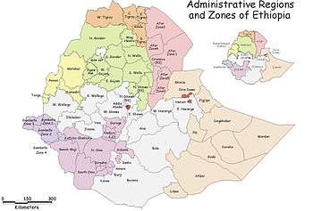
Gurage is a Zone in the Ethiopian Southern Nations, Nationalities, and Peoples' Region (SNNPR). This zone is named for the Gurage people, whose homeland lies in this zone. Gurage is bordered on the southeast by Hadiya and Yem special woreda, on the west, north and east by the Oromia Region, and on the southeast by Silt'e. Its highest point is Mount Gurage. Welkite is the administrative center of the Zone; Butajira is the largest city in this zone and the former administrative center. Other towns in Gurage include Endibir and Enseno.
Overview
Most parts of this Zone are heavily eroded, which required farmers to protect their enset fields with stone and soil bunds. During the 1930s, about 20% of the land in Gurage was covered with natural forests, which has since been almost completely cut down; the removal was especially fast during the years 1991 and 1992. As of 1996 one of the largest natural forests is Ziarem forest (also known as Forehina), about 800 hectares in size. On the other hand, beginning in the early 1960s the inhabitants started to grow eucalyptus on an increasing scale, which has increased the amount of land being covered with trees.[1] This Zone has 783 kilometers of all-weather roads and 281 kilometers of dry-weather roads, for an average road density of 182 kilometers per 1000 square kilometers.[2]
The Central Statistical Agency (CSA) reported that 7,624 tons of coffee were produced in Gurage, Hadiya and Kembata Tembaro combined in the year ending in 2005, based on inspection records from the Ethiopian Coffee and Tea authority. This represents 7.6% of the SNNPR's output and 3.36% of Ethiopia's total output.[3]
Following a referendum held between 18 and 26 April 2001, the Silt'e unanimously voted to form their own Zone, Silt'e.[4]
Demographics
Based on the 2007 Census conducted by the Central Statistical Agency of Ethiopia (CSA), this Zone has a total population of 1,279,646, of whom 622,078 are men and 657,568 women; with an area of 5,893.40 square kilometers, Gurage has a population density of 217.13. While 119,822 or 9.36% are urban inhabitants, a further 3 individuals are pastoralists. A total of 286,328 households were counted in this Zone, which results in an average of 4.47 persons to a household, and 276,570 housing units. The six largest ethnic groups reported in Gurage were the Gurage people (82%), the Mareqo or Libido (4.28%), the Amhara (3.36%), the Kebena (3.34%), the Silt'e people (2.71%), and the Oromo (1.69%); all other ethnic groups made up 2.62% of the population. Gurage languages are spoken as a first language by 80.54% of the population, 5.28% spoke Amharic, 4.09% spoke Libido, 3.2% spoke Kebena, 2.98% spoke Silt'e, and 1.06% spoke Oromo; the remaining 2.85% spoke all other primary languages reported. The majority of the inhabitants were reported as Muslim, with 51.02% of the population reporting that belief, while 41.91% practiced Ethiopian Orthodox Christianity, 5.79% were Protestants, and 1.12% Catholic.[5]
The 1994 national census reported a total population for this Zone of 1,556,964, of whom 755,490 were men and 801,474 women; 76,988 or 4.94% of its population were urban dwellers at the time. The six largest ethnic groups reported in Gurage were the Sebat Bet Gurage (45.02%), the Silt'e (34.81%), the Soddo Gurage (9.75%), the Mareqo or Libido (2.21%), the Amhara (2.16%), and the Kebena (1.82%); all other ethnic groups made up 4.21% of the population. Sebat Bet Gurage is spoken as a first language by 39.93%, 35.04% Silt'e, 10.06% spoke Soddo Gurage, 3.93% spoke Amharic, 2.16% spoke Libido, and 1.93% spoke Kebena; the remaining 6.95% spoke all other primary languages reported. The majority of the inhabitants were reported as Muslim, with 63.98% of the population reporting that belief, while 32.97% practiced Ethiopian Orthodox Christianity, 1.9% were Protestants, and 0.95% Catholic.[6]
According to a May 24, 2004 World Bank memorandum, 3% of the inhabitants of Gurage have access to electricity, this zone has a road density of 95.4 kilometers per 1000 square kilometers, the average rural household has 0.5 hectare of land (compared to the national average of 1.01 hectare of land and an average of 0.89 for the SNNPR)[7] the equivalent of 0.2 heads of livestock. 18.9% of the population is in non-farm related jobs, compared to the national average of 25% and a Regional average of 32%. 79% of all eligible children are enrolled in primary school, and 12% in secondary schools. 18% of the zone is exposed to malaria, and 38% to Tsetse fly. The memorandum gave this zone a drought risk rating of 319.[8]
Notes
- ↑ "Ethiopian Village Studies: Imbdibir", Centre for the Study of African Economies (accessed 5 July 2009)
- ↑ "Detailed statistics on roads", SNNPR Bureau of Finance and Economic Development website (accessed 3 September 2009)
- ↑ CSA 2005 National Statistics, Table D.2
- ↑ Sarah Vaughan, "Ethnicity and Power in Ethiopia" (University of Edinburgh: Ph.D. Thesis, 2003), p. 265
- ↑ Census 2007 Tables: Southern Nations, Nationalities, and Peoples' Region, Tables 2.1, 2.4, 2.5, 3.1, 3.2 and 3.4.
- ↑ 1994 Population and Housing Census of Ethiopia: Results for Southern Nations, Nationalities, and Peoples' Region, Vol. 1, part 1, Tables 2.1, 2.11, 2.14, 2.17 (accessed 30 December 2008).
- ↑ Comparative national and regional figures comes from the World Bank publication, Klaus Deininger et al. "Tenure Security and Land Related Investment", WP-2991 (accessed 23 March 2006)
- ↑ World Bank, Four Ethiopias: A Regional Characterization (accessed 23 March 2006).
External links
Coordinates: 8°10′N 38°15′E / 8.167°N 38.250°E
| Current zones |  | |
|---|---|---|
| Former zones | ||
| Special woredas | ||
Woredas of the Gurage Zone | ||
|---|---|---|
| Former woredas | ||
| Current woredas | ||