Greenburgh, New York
| Greenburgh, New York | |
|---|---|
| Town | |
 Location of Greenburgh, New York | |
| Coordinates: 41°1′55″N 73°49′59″W / 41.03194°N 73.83306°WCoordinates: 41°1′55″N 73°49′59″W / 41.03194°N 73.83306°W | |
| Country | United States |
| State | New York |
| County | Westchester |
| Founded | 1788[1] |
| Government | |
| • Type | Manager-Council |
| • Town Supervisor | Paul J. Feiner (D) |
| • Town Council |
Members
|
| Area | |
| • Total | 36.1 sq mi (93.5 km2) |
| • Land | 30.3 sq mi (78.5 km2) |
| • Water | 5.8 sq mi (15.0 km2) |
| Elevation | 171 ft (52 m) |
| Population (2010) | |
| • Total | 88,400 |
| • Density | 2,917/sq mi (1,126.1/km2) |
| Time zone | Eastern (EST) (UTC-5) |
| • Summer (DST) | EDT (UTC-4) |
| ZIP code | 10607 |
| Area code(s) | 914 |
| FIPS code | 36-30367 |
| GNIS feature ID | 0979017 |
| Website |
www |
Greenburgh is a town in the western part of Westchester County, New York, United States. The population was 88,400 at the 2010 census.[2]
History
The Romer-Van Tassel House served as the first town hall from 1793 into the early 19th century.[3] It was added to the National Register of Historic Places in 1994.[4] Other locations on the National Register are the Church of St. Joseph of Arimathea and Odell House.[4] The Spanish American War Monument to the 71st Infantry Regiment in Mount Hope Cemetery was listed on the National Register of Historic Places in 2011.[5]
Geography
Greenburgh is bordered by the city of Yonkers on the south, the town of Mount Pleasant to the north, and to the east by the city of White Plains and the town of Scarsdale.[6] The western boundary is the Hudson River.[6] The Tappan Zee Bridge connects Tarrytown in Greenburgh with South Nyack in Orangetown, New York.[7]
According to the United States Census Bureau, the town has a total area of 36.1 square miles (93.5 km2), of which 30.3 square miles (78.5 km2) is land and 5.8 square miles (15.0 km2), or 16.07%, is water.[2]
Demographics
| Historical population | |||
|---|---|---|---|
| Census | Pop. | %± | |
| 1790 | 1,450 | — | |
| 1820 | 2,064 | — | |
| 1830 | 2,195 | 6.3% | |
| 1840 | 3,361 | 53.1% | |
| 1850 | 4,291 | 27.7% | |
| 1860 | 8,929 | 108.1% | |
| 1870 | 10,790 | 20.8% | |
| 1880 | 8,934 | −17.2% | |
| 1890 | 11,613 | 30.0% | |
| 1900 | 15,564 | 34.0% | |
| 1910 | 21,148 | 35.9% | |
| 1920 | 23,881 | 12.9% | |
| 1930 | 35,821 | 50.0% | |
| 1940 | 40,145 | 12.1% | |
| 1950 | 47,527 | 18.4% | |
| 1960 | 76,213 | 60.4% | |
| 1970 | 85,827 | 12.6% | |
| 1980 | 82,881 | −3.4% | |
| 1990 | 83,816 | 1.1% | |
| 2000 | 86,764 | 3.5% | |
| 2010 | 88,400 | 1.9% | |
| Est. 2014 | 91,388 | [8] | 3.4% |
As of the 2000 census,[10] there were 86,764 people, 33,043 households, and 23,097 families residing in the town. The population density was 2,842.7 people per square mile (1,097.6/km²). There were 34,084 housing units at an average density of 1,116.7 per square mile (431.2/km²). The racial makeup of the town was 72.41% White, 13.07% African American, 0.17% Native American, 8.77% Asian, 0.05% Pacific Islander, 2.94% from other races, and 2.59% from two or more races. Hispanic or Latino of any race were 9.02% of the population.
There were 33,043 households out of which 32.4% had children under the age of 18 living with them, 57.3% were married couples living together, 9.8% had a female householder with no husband present, and 30.1% were non-families. 25.5% of all households were made up of individuals and 9.1% had someone living alone who was 65 years of age or older. The average household size was 2.57 and the average family size was 3.10.
In the town the population was spread out with 23.7% under the age of 18, 5.9% from 18 to 24, 29.7% from 25 to 44, 26.2% from 45 to 64, and 14.6% who were 65 years of age or older. The median age was 40 years. For every 100 females there were 90.3 males. For every 100 females age 18 and over, there were 84.5 males.
According to a 2007 estimate, the median income for a household in the town was $100,656, and the median income for a family was $118,360.[11] Males had a median income of $64,186 versus $46,658 for females. The per capita income for the town was $43,778. About 2.0% of families and 3.9% of the population were below the poverty line, including 3.4% of those under age 18 and 4.8% of those age 65 or over.
By 1991 5% of the community's population was of Asian origins.[12]
Communities and locations in Greenburgh
Roughly half of Greenburgh's population lies within the town's six incorporated villages. The rest of the population lives in the unincorporated area of the town of Greenburgh, outside any villages.

Villages
Greenburgh contains six villages:
Unincorporated area
The unincorporated area of Greenburgh consists of the formerly rural areas of the town outside the villages. While hamlets are not recognized as municipal entities in New York State, most properties in unincorporated Greenburgh are classified within one of the town's three federally recognized zones, each known as a census-designated place, which generally correspond to a fire district.
- Fairview
- Greenville (commonly known as Edgemont)
- Hartsdale
Other unincorporated areas in Greenburgh outside of the three main CDPs include the neighborhoods of:
- East IrvingtonA
- North Elmsford
- South Ardsley
Transportation
Interstate 87 (the New York State Thruway), the Cross Westchester Expressway, the Saw Mill River Parkway, the Bronx River Parkway, and the Sprain Brook Parkway all pass through the town. US routes include U.S. Route 9. State routes that traverse the town are Route 9A, Route 100 (as well as A, B and C) and Route 119.
The Metro-North Railroad's Hudson Line passes through the west of the town with stations at Hastings-on-Hudson, Dobbs Ferry, Ardsley-on-Hudson, Irvington and Tarrytown, and its Harlem Line passes through the east of the town with a station at Hartsdale.
Westchester County's Bee-Line Bus System also serves the town, and Transport of Rockland's Tappan ZEExpress provides connections across the Tappan Zee Bridge to Rockland County.
Economy
The Westchester Library System headquarters are in the town, near Tarrytown.[13][14][15] As of 2014, The income per capita in Greenburgh is $55,049. The median household income is $100,282.[16]
Notable residents
Celebrities who lived in Greenburgh included wrestler "Classy" Freddie Blassie, jazz great Cab Calloway, photographer Gordon Parks, and comedian Jackie "Moms" Mabley. Other notables include Lowell Hawthorne, the Founder/CEO of GoldenKrust, a Jamaican franchise chain restaurant in the US, and Biff Henderson, of the various David Letterman shows. NBA players who play for the New York Knicks basketball team may also be seen around since one of their training facilities is based here.
- Dana Reeve, actress and wife of Christopher Reeve
- Roy Campanella, professional baseball player
References
- Explanatory notes
A.^ The community of East Irvington is centered on the intersection of East Sunnyside Lane, Taxter Road and Mountain Road at 41°02′49″N 73°50′56″W / 41.047°N 73.849°W. It consists primarily of unincorporated parts of the town of Greenburgh, but is also commonly considered to include adjoining parts of the villages of Irvington and Tarrytown which branch off from East Sunnyside Lane and Mountain Road. The community has no official status, but is nonetheless recognized in names of Greenburgh facilities such as "East Irvington Park" and the "East Irvington Nature Preserve", as well as in the East Irvington School, formerly a facility of the Irvington School District and now converted to condominiums. (The school was listed on the National Register of Historic Places in 1983.[4]) East Irvington was formerly known as "Little Dublin" from the population of Irish immigrant laborers there who worked on the large estates in the area, on the railroads and docks, or in the stone quarries, the remnants of which still exist.
- Citations
- ↑ http://www.greenburghny.com/
- 1 2 "Geographic Identifiers: 2010 Demographic Profile Data (G001): Greenburgh town, Westchester County, New York". U.S. Census Bureau, American Factfinder. Retrieved January 29, 2013.
- ↑ John A. Bonafide (August 1994). "National Register of Historic Places Registration:Romer-Van Tassel House". New York State Office of Parks, Recreation and Historic Preservation. Retrieved 2010-12-24.
- 1 2 3 National Park Service (2009-03-13). "National Register Information System". National Register of Historic Places. National Park Service.
- ↑ "National Register of Historic Places Listings". Weekly List of Actions Taken on Properties: 1/10/11 through 1/14/11. National Park Service. 2011-01-21.
- 1 2 Greenburgh GIS map
- ↑ "Tappan Zee Bridge" on the New York State Thruway Authority website
- ↑ "Annual Estimates of the Resident Population for Incorporated Places: April 1, 2010 to July 1, 2014". Retrieved June 4, 2015.
- ↑ "Census of Population and Housing". Census.gov. Retrieved June 4, 2015.
- ↑ "American FactFinder". United States Census Bureau. Retrieved 2008-01-31.
- ↑ U.S. Census Bureau: Greenburgh town, Westchester County, New York
- ↑ Handelman, David. "The Japanizing of Scarsdale: East Meets Westchester." New York Magazine (ISSN 0028-7369). New York Media, LLC, April 29, 1991. Vol. 24, No. 17. p. 40-45. CITED: p. 42.
- ↑ "Home." Westchester Library System. Retrieved on August 8, 2011. "Westchester Library System | 540 White Plains Road | Suite 200 | Tarrytown, NY 10591"
- ↑ "Zoning Map." Retrieved on 8 August 2011.
- ↑ "Greenburgh town, Westchester County, New York." U.S. Census Bureau. Retrieved on August 8, 2011.
- ↑ "Sperling's Best Places".
External links
- Town of Greenburgh official website
- Tocqueville in Greenburgh - Segment from C-SPAN's Alexis de Tocqueville Tour
Municipalities and communities of Westchester County, New York, United States | ||
|---|---|---|
| Cities | 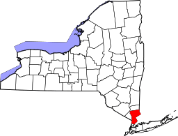 | |
| Towns | ||
| Villages | ||
| CDPs | ||
| Other hamlets | ||
| Footnotes | ‡This populated place also has portions in an adjacent county or counties | |