Green Mountain
| Green Mountain, Ascension Island | |
|---|---|
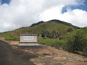 Entrance to Green Mountain (2011) | |
| Highest point | |
| Elevation | 859 m (2,818 ft) [1] |
| Prominence | 859 m (2,818 ft) |
| Isolation | 1,842 kilometres (1,145 mi) |
| Coordinates | 7°57′S 14°21′W / 7.950°S 14.350°WCoordinates: 7°57′S 14°21′W / 7.950°S 14.350°W |
| Geography | |
| Location | Ascension Island, South Atlantic Ocean |
| Geology | |
| Age of rock | Holocene |
| Mountain type | Stratovolcano |
| Last eruption | Unknown |
| Climbing | |
| Easiest route | aircraft, then road, then hike |
Green Mountain is a common name for "The Peak", the highest point on Ascension Island, which has gained some fame for claims that it is one of very few large-scale artificial forests.
History and vegetation
Many early 19th-century accounts, including Charles Darwin's (July 1836), described the volcanic island as barren with very few plants, some of them endemic to the island, not to be found anywhere else. Scientists estimate the island's native vascular plants to be between 25 and 30 species, 10 of them endemic to Ascension (Ashmole 2000, Gray et al. 2005). This impoverished flora is a consequence of the age of the island (only 1 million years old) and isolation (over 1,500 kilometres (930 mi) - from any major landmass).[2] Then, in 1843, the British plant collector Joseph Dalton Hooker visited the island with Sir James Clark Ross's Antarctica expedition. Hooker proposed a plan to plant the island with vegetation to attempt to increase rainfall and make life more bearable for the garrison that was stationed there (see Duffey 1964). Crucially he saw the appointment of a farm superintendent as being the key to success.
From that time on many plants have been introduced and Hooker's plan can be seen from one angle as an overwhelming success. An 1865 Admiralty report stated on the subject of Green Mountain that "(the island) now possesses thickets of 40 kinds of trees, besides numerous shrubs; through the spreading of vegetation, the water supply is now excellent". By the early 1900s many crops such as bananas and guavas were growing naturally. It is unlikely that this success led to an increase in rainfall, however, but increased capture of occult deposition (mist) by the greater amount of vegetation has probably resulted.
The resulting cloud forest (Wilkinson 2004 and Gray 2004), is a mosaic of plants from a variety of habitats including woodland, grassland, and shrubland. The ecosystem that has emerged is interesting for its almost entirely artificial nature as a result of the interactions between the introduced species from a variety of disparate climates and locations.[3] The resulting ecosystem created by the British introductions has threatened several of the few endemic Ascension island species. Because of this, Green Mountain is now a national park where endemic species are actively conserved.
The mineral dalyite was first found at Green Mountain.[4]
Geography and access
The Mountain, situated within the national park zone can be accessed via the main road from Georgetown. However vehicle access does not extend to the top of the mountain. A footpath exists up to the old barracks and disused water catchment area. This continues to an observation station, where there is also a Dew Pond, formed by the collection of water on top of the mountain. The area is maintained for visitors to a certain extent and a passage is provided through the dense vegetation. The highest point of the mountain is marked by an anchor chain, which is just up from the Dew Pond.
-
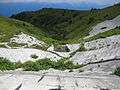
The Old Water Catchment Area, which was once the main supply of water for the island.
-
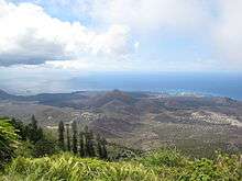
View from atop Green Mountain, showing Ascension island and the settlement of Two Boats in centre.
-
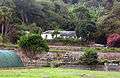
House on the mountain.
See also
- Coevolution
- Ecological fitting
- International Mineralogical Association
- List of mountains and hills of Saint Helena, Ascension and Tristan da Cunha
- Terraforming
References
- ↑ DPS.plants.ox.ac.uk
- ↑ DPS.plants.ox.ac.uk
- ↑ P. Ashmole and M. Ashmole: St. Helena and Ascension Island: a natural history, 2000, page 250.
- ↑ Dalyite mineral information and data
Literature
- P. Ashmole and M. Ashmole (2000). St. Helena and Ascension Island: a natural history
- E. Duffey (1964). The Terrestrial Ecology of Ascension Island. The Journal of Applied Ecology, 1, (2), pp. 219–251.
- A. Gray, T. Pelembe and S. Stroud (2005).The conservation of the endemic vascular flora of Ascension Island and threats from alien species. Oryx 39, (4), pp. 449–453.
- Gray, Alan (2004-08-24). "The parable of Green Mountain: massaging the message". Journal of Biogeography. 31 (9): 1549–1550. doi:10.1111/j.1365-2699.2004.01118.x.
- Wilkinson, David M. (2003-12-22). "The parable of Green Mountain: Ascension Island, ecosystem construction and ecological fitting" (PDF). Journal of Biogeography. 31 (1): 1–4. doi:10.1046/j.0305-0270.2003.01010.x. Retrieved 2010-09-02.