Great Glen Way
| Great Glen Way Slighe a' Ghlinne Mhòir | |
|---|---|
|
Map of the Great Glen Way | |
| Established | 2002 |
| Length | 127 km (79 mi) |
| Location | Scotland |
| Designation | Long Distance Route |
| Trailheads |
Fort William Inverness |
| Use | Hiking, Mountain biking |
| Elevation | |
| Highest point | Abriachan Forest, 375 m (1,230 ft) |
| Hiking details | |
| Season | All year |
The Great Glen Way (Scottish Gaelic: Slighe a' Ghlinne Mhòir) is a long distance path in Scotland. It follows the Great Glen, running from Fort William in the west to Inverness in the east, covering 79 miles (127 kilometres). It was opened in 2002 and is one of Scotland's four Long Distance Routes. The Great Glen Way is generally walked from west to east to follow the direction of the prevailing wind. It can be walked in 5–6 days, or cycled in 2–3 days.
Route description
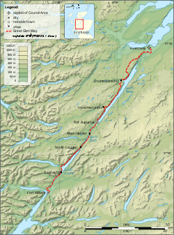
Beginning at the Old Fort in Fort William the Great Glen Way skirts the shores of Loch Linnhe to Corpach, and the Caledonian Canal. The eight locks of Neptune's Staircase takes the canal to 19.2m above sea level. The route passes various canal features until Loch Lochy when forest tracks take it along the western shore before rejoining the canal at Laggan Locks. A detour to visit a couple of Munros is an option here, but it is likely to take the best part of the day.

From Laggan Locks the route follows the towpath through Laggan Avenue to the Laggan Swing Bridge. Crossing the A82 road it then runs along the eastern shores of Loch Oich, partly following the route of the dismantled Invergarry and Fort Augustus Railway. It joins back on to the canal towpath at Aberchalder, for the next section into Fort Augustus. An alternative route known as the "Invergarry Link" runs along the western side of Loch Oich, providing access to accommodation and shops in Invergarry.
From Fort Augustus the route climbs away from the canal and up into the forest above Loch Ness. There are views from the high level forest track which eventually drops into Invermoriston and out by a steep climb. High level forest track leads into the hamlet of Grotaig then alongside the road until a path heads down through Clunebeg Wood to the banks of the River Coiltie and Borlum Bridge. Then through the village of Drumnadrochit, and up a steep hill to Abriachan. The Great Glen Way ascends a forest track giving good views traversing through the forest. Leaving the road at Blackfold, the waymarking indicates forest track at Craig Leach Forest which eventually emerges at a reservoir. The route runs downhill through the suburbs of Inverness, then follows the canal and the River Ness to the city centre, finishing at Inverness Castle.
The Great Glen Way was first swum by Marathon swimmer Alina Warren,[1] who completed the 117 km in July 2012.[2] The swim used all three lochs, and river Ness, river Oich and the river Lochy instead of the canals.
References
- ↑ http://www.alinawarren.co.uk
- ↑ http://www.openwaterswimming.com/alina-warren-completes-the-great-glen-way/
External links
| Wikimedia Commons has media related to Great Glen Way. |
| Wikivoyage has a travel guide for Great Glen Way. |
- Official website
- Step-by-step guide to the route on Walkhighlands
- A useful unofficial site
- Official Facebook page
- Great Glen Ways and Caledonian Canal - Youtube