Grafton, New South Wales
| Grafton New South Wales | |||||||
|---|---|---|---|---|---|---|---|
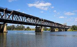 Grafton Bridge across the Clarence River | |||||||
 Grafton | |||||||
| Coordinates | 29°41′0″S 152°56′0″E / 29.68333°S 152.93333°ECoordinates: 29°41′0″S 152°56′0″E / 29.68333°S 152.93333°E | ||||||
| Population | 18,689 (2015)[1] | ||||||
| Established | 1851 | ||||||
| Postcode(s) | 2460 | ||||||
| Elevation | 5 m (16 ft) | ||||||
| Location | |||||||
| LGA(s) | Clarence Valley Council | ||||||
| County | Clarence | ||||||
| State electorate(s) | Clarence | ||||||
| Federal Division(s) | Page | ||||||
| |||||||
The city of Grafton is the seat of local government, the Federal and State government admimistrative centre, and the commercial hub of the Clarence River Valley. Established in 1851, Grafton features many historic buildings and tree-lined streets. It is located approximately 630 kilometres north of the New South Wales State capital, Sydney, 340 km south of Brisbane, Queensland and approximately 35 km west of the Tasman Sea coast. As at June 2015, Grafton had a population of 18,689.[1]
History
Before European settlement, the Clarence River marked the border between the Bundjalung[2] and Gumbaynggirr peoples, and so descendants of both language groups can now be found in the Grafton region.
Grafton, like many other settlements in the area, was first opened up to white settlement by the cedar-getters. An escaped convict, Richard Craig, 'discovered' the district in 1831. With the wealth of 'red gold' cedar just waiting for exploitation, he was given a pardon and one hundred pounds to bring a party of cedar-getters on the cutter 'Prince George' to the region. Word of such wealth to be had did not take long to spread and one of the arrivals was pioneer John Small on the 'Susan' in 1838, and he first occupied land on Woodford Island. 'The Settlement' (as the embryonic Grafton was then imaginatively named) was established shortly after.
In 1851, Governor FitzRoy officially named the town "Grafton", after his grandfather, the Duke of Grafton, a former Prime Minister of the United Kingdom.[3] Grafton was proclaimed a city in 1885. Local industries include logging, beef cattle, fishing/prawning, sugar, manufacturing and tourism.
The town is also known for its double-decker road/railway bridge, opened in 1932, completing the standard gauge rail connection between Sydney and Brisbane, and also forming a vital link for the Pacific Highway. This bridge is a one of a kind and is a major feature on the Clarence River in Grafton.
Climate
Grafton has a humid subtropical climate with significantly more rainfall and higher temperatures in summer than in winter. Rainfall is lower than in stations directly on the coast, but monthly rain totals can often surpass 300 millimetres (12 in). The wettest month since records began was March 1974 when Cyclone Zoe produced a monthly total of 549.0 millimetres (21.61 in), whilst during periods of anticyclonic control and strong westerly winds monthly rainfall can be very low; for instance in July 1972 only 0.3 millimetres (0.01 in) fell. Grafton gets around 115.2 clear days on an annual basis.
| Climate data for Grafton | |||||||||||||
|---|---|---|---|---|---|---|---|---|---|---|---|---|---|
| Month | Jan | Feb | Mar | Apr | May | Jun | Jul | Aug | Sep | Oct | Nov | Dec | Year |
| Record high °C (°F) | 43.8 (110.8) |
42.1 (107.8) |
39.0 (102.2) |
36.7 (98.1) |
31.7 (89.1) |
30.5 (86.9) |
28.2 (82.8) |
36.3 (97.3) |
38.3 (100.9) |
39.3 (102.7) |
43.8 (110.8) |
43.4 (110.1) |
43.8 (110.8) |
| Average high °C (°F) | 30.1 (86.2) |
29.3 (84.7) |
28.3 (82.9) |
26.2 (79.2) |
23.1 (73.6) |
20.8 (69.4) |
20.5 (68.9) |
22.1 (71.8) |
24.8 (76.6) |
26.7 (80.1) |
28.1 (82.6) |
29.7 (85.5) |
25.8 (78.4) |
| Average low °C (°F) | 19.7 (67.5) |
19.7 (67.5) |
18.0 (64.4) |
14.9 (58.8) |
11.3 (52.3) |
8.1 (46.6) |
6.3 (43.3) |
7.3 (45.1) |
10.4 (50.7) |
13.7 (56.7) |
16.2 (61.2) |
18.4 (65.1) |
13.7 (56.7) |
| Record low °C (°F) | 12.8 (55) |
12.7 (54.9) |
10.8 (51.4) |
3.6 (38.5) |
0.5 (32.9) |
−2.0 (28.4) |
−2.2 (28) |
−0.2 (31.6) |
1.8 (35.2) |
3.9 (39) |
6.7 (44.1) |
7.0 (44.6) |
−2.2 (28) |
| Average rainfall mm (inches) | 138.9 (5.469) |
145.3 (5.72) |
129.8 (5.11) |
89.2 (3.512) |
81.8 (3.22) |
69.1 (2.72) |
39.2 (1.543) |
39.5 (1.555) |
36.7 (1.445) |
80.1 (3.154) |
104.4 (4.11) |
120.5 (4.744) |
1,074.5 (42.302) |
| Average rainy days (≥ 1.0 mm) | 10.7 | 11.0 | 11.1 | 8.0 | 7.7 | 5.7 | 4.6 | 4.3 | 5.3 | 7.4 | 9.3 | 10.1 | 95.2 |
| Average relative humidity (%) | 56 | 60 | 59 | 57 | 57 | 54 | 49 | 43 | 44 | 49 | 52 | 54 | 52.8 |
| Source: "Climate statistics for Grafton". Bureau of Meteorology. Retrieved 27 May 2013. | |||||||||||||
Culture
Grafton is known and promoted as the Jacaranda City, in reference to its tree-lined streets and to the annual Jacaranda Festival. Inaugurated in 1935, Jacaranda is held each October/November. A half-day public holiday is observed locally on the first Thursday of November, the Festival's focal day.
A half-day public holiday is also observed for the Grafton Cup horse race, held each year on the second Thursday in July. It is the high point of the city's annual Racing Carnival—Australia's largest and richest non-metropolitan Carnival—which takes place over a fortnight in that month.
Grafton is the birthplace of several renowned country music players. Local artist Troy Cassar-Daley received four Golden Guitar awards at the 2006 Tamworth Country Music Awards—the largest and most prestigious country music awards in Australia. At the same event Samantha McClymont, the 2005/2006 Grafton Jacaranda Queen and sister of Brooke McClymont, also received an award for her country music talent.
A vision of Grafton with its numerous brilliantly-flowered trees in bloom is immortalised in Australian popular music in Cold Chisel's song Flame Trees, written by band member Don Walker, who had lived in Grafton during his formative years.
Notable buildings
Christ Church Cathedral, designed by John Horbury Hunt, was consecrated in 1884 and is the seat of the Anglican Diocese of Grafton.[4]
Schaeffer House is a historic 1900 Federation house and contains the collection of the Clarence River Historical Society, which was formed in 1931.
One of the most historic homes is the Schoolmaster's House and the Schoolhouse, built in 1882 at Carrs Creek. It is now privately owned and faithfully restored with its manicured grounds.
Transportation

The Murwillumbah – Byron Bay – Lismore railway (opened in 1894) was extended to Grafton in 1905;[5] for details, see Murwillumbah railway line. The North Coast Line reached South Grafton from Sydney in 1915. Pending the opening of the combined road and rail bascule bridge in 1932, Grafton had a train ferry to connect the two railways. Clarence Valley Regional Airport is the airport that services Grafton.
Grafton also lies on the Pacific Highway, the main North–South road route through Eastern Australia, and links it to the Gwydir Highway, one of the primary East-West routes through Eastern Australia.
Industry
Harwood Mill is the oldest working sugar mill in New South Wales.
Newspapers
The daily newspaper of Grafton is The Daily Examiner, owned by media conglomerate Australian Provincial Newspapers (APN), part of the media empire controlled by Irish magnate Tony O'Reilly.
Radio and television
Radio stations
- 2GF 1206 AM/103.9 FM (commercial)
- FM 104.7 (commercial)
- Triple J 91.5 FM/96.1 FM
- ABC Northern Rivers 738 AM/94.5 FM
- ABC Classic FM 97.9 FM/95.3 FM
- Radio National 99.5 FM/96.9 FM
- Racing Radio 101.5 FM
- Life FM 103.1 (community)
- Raw FM 87.6
Television channels
- Prime7, 7TWO, 7mate, (Seven Network affiliated channels)
- NBN Television, GEM HD, Go! (Australian TV channel), owned and operated by the (Nine Network)
- Southern Cross Ten, One HD, and Eleven, (Network Ten) affiliated channels
- ABC Television including ABC1, ABC2, ABC3 and ABC News 24, part of the Australian Broadcasting Corporation
- Special Broadcasting Service, SBS One and SBS Two
Pay television services are provided by Austar.
Education
Public schools
- Gillwinga Public School
- Grafton High School
- Grafton Public School
- South Grafton High School
- South Grafton Public School
- Westlawn Public School
Independent schools
- Clarence Valley Anglican School (formerly The Cathedral School)[6]
- McAuley Catholic College
- St. Joseph's Primary School
- St. Mary's Primary School
- St. Andrew's Christian School
Notable people
Notable people from Grafton include:
- Troy Cassar-Daley, Country musician
- Fanny Cohen (born 1887), headmistress[7]
- Matthew Colless (born 1960) astronomer [8] Professor Matthew Colless is the Director of the Research School of Astronomy and Astrophysics (RSAA) at the Australian National University(ANU). He was for nine years previously the Director of the Australian Astronomical Observatory (AAO), Australia's national optical observatory.[9]
- Peter Drysdale (born 1938), economist
- Adam Eckersley, musician
- Nick Emmett, rugby league player
- James Eggins (1898–1952), politician
- Elizabeth Essex-Cohen (21 April 1940 – 21 March 2004), gained international recognition as an ionosphere physicist with her pioneering work on the Global Positioning System (GPS)[10]
- Gary Foley (born 1950), Aboriginal activist, academic, writer
- Charles Hercules Green (1919–1950), officer
- George Green (1883–unknown), rugby league player
- Bill Hirschberg (1880–unknown), rugby union player
- Robyn Lambley (born 1965), politician
- Sir Walter McEllister (Mac) Leonard (born 1915) businessman, recognised for his role as CEO at Ampol[11]
- Jim Lisle (1939–2003), rugby league and rugby union player
- Brent Livermore (born 5 July 1976), field hockey midfielder
- The McClymonts, country music group consisting of sisters Brooke, Samantha and Mollie
- Frank McGuren (1909–1990), politician
- Iven Giffard Mackay (7 April 1882 – 30 September 1966), Lieutenant General[3]
- Bill McLennan (born 1942), statistician
- Chris Masters (born 1948), journalist
- Gillian Mears (born 1964), author
- James Lionel Michael, poet and solicitor (moved to Grafton 1861, died in Grafton 1868)
- Tony Mundine (born 1951), boxer
- Warren Mundine (born 1956), politician
- Kevin Nichols (born 1955), track cyclist
- Sir Earle Page (8 August 1880 – 20 December 1961), Prime Minister of Australia, 1939
- Geoff Page, (born 1940) Poet
- Ruby Payne-Scott (1912–1981), pioneer in radiophysics and radio astronomy
- Frank Partridge (1924–1964), recipient of the Victoria Cross
- Cameron Pilley (born 1982), squash player
- Eddie Purkiss (born 1934), rugby union player
- Tyrone Roberts (born 1 June 1991), Newcastle Knights footballer
- Henry Ernest Searle (1866–1889), rower[3]
- Sir Grafton Elliot Smith (15 August 1871 – 1 January 1937), anatomist and palaeoanthropologist[3]
- James Tully (1877–1962), politician
- William Edward Vincent (1823–1861), founded The Clarence and Richmond Examiner
- Brenda Walker (born 1957), writer
- Don Walker (born 1951), Musician
- Arthur Bache Walkom (1889–1976), palaeobotanist and museum director
- Bill Weiley (1901–1989), politician
- Danny Wicks (born 1985), rugby league player
- Graham Wilson, rugby league footballer of the 1960s
- Walter George Woolnough (1876–1958), geologist
- Beau Young (born 1974), singer-songwriter, surfer
See also
References
- 1 2 "3218.0 – Regional Population Growth, Australia, 2014-15: Population Estimates by Significant Urban Area, 2005 to 2015". Australian Bureau of Statistics. Australian Bureau of Statistics. 30 March 2016. Retrieved 12 September 2016. Estimated resident population, 30 June 2015.
- ↑ Tindale, Norman (1974) "Badjalang" in his Catalogue of Australian Aboriginal Tribes. South Australian Museum
- 1 2 3 4 "The romance of Australian place names.". The Australian Women's Weekly. National Library of Australia. 27 May 1964. p. 59. Retrieved 14 October 2013.
- ↑ Diocese of Grafton. "Grafton Cathedral". Retrieved 19 May 2006.
- ↑ Grafton—Rail Centre of the Clarence for 100 Years Milne, Rod Australian Railway Historical Society, November 2005, pp. 443–463
- ↑ "History of the Cathedral and the Close". Christ Church Cathedral Grafton. Retrieved 1 January 2014.
- ↑ "Cohen, Fanny (1887–1975)". Australian Dictionary of Biographies. 1981. Retrieved 30 March 2015.
- ↑ http://trove.nla.gov.au/work/20318515?versionId=24002940
- ↑ https://researchers.anu.edu.au/researchers/colless-mm
- ↑ University of Melbourne. "Essex-Cohen, Elizabeth Annette". Retrieved 18 June 2008.
- ↑ Dyster, Barry. "Leonard, Sir Walter McEllister (Mac) (1915–1985)". Australian Dictionary of Biography. Canberra: Australian National University. Retrieved 30 March 2015.
External links
| Wikimedia Commons has media related to Grafton, New South Wales. |
- Grafton, tropicalnsw.com.au
- Photographs of Grafton in 1994, National Library of Australia
- Jacaranda Festival Grafton
- Gillwinga Public School
- Grafton High School
- Grafton Public School
- South Grafton High School
- South Grafton Public School
- Westlawn Public School
- Clarence Valley Anglican School
- St Josephs Primary School
- St Mary's Primary School
- St. Andrew's Christian School
| Preceding station | NSW Main lines | Following station | ||
|---|---|---|---|---|
towards Border Loop | North Coast Line | towards Maitland |
||
| Preceding station | NSW TrainLink | Following station | ||
| NSW TrainLink North Coast | towards Sydney |
|||