Grafton, New Hampshire
| Grafton, New Hampshire | ||
|---|---|---|
| Town | ||
|
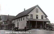
Grafton Center c. 1909 | ||
| ||
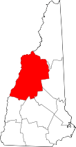
 Location in Grafton County, New Hampshire | ||
| Coordinates: 43°34′24″N 71°58′26″W / 43.57333°N 71.97389°WCoordinates: 43°34′24″N 71°58′26″W / 43.57333°N 71.97389°W | ||
| Country | United States | |
| State | New Hampshire | |
| County | Grafton | |
| Incorporated | 1778 | |
| Government | ||
| • Board of Selectmen |
Leon Dugan, Chair Merle Kenyon John Sullivan | |
| Area | ||
| • Total | 42.6 sq mi (110.4 km2) | |
| • Land | 41.7 sq mi (107.9 km2) | |
| • Water | 0.9 sq mi (2.4 km2) 2.19% | |
| Elevation | 870 ft (265 m) | |
| Population (2010) | ||
| • Total | 1,340 | |
| • Density | 31/sq mi (12/km2) | |
| Time zone | Eastern (UTC-5) | |
| • Summer (DST) | Eastern (UTC-4) | |
| ZIP code | 03240 | |
| Area code(s) | 603 | |
| FIPS code | 33-30820 | |
| GNIS feature ID | 0873609 | |
| Website |
www | |


Grafton is a town in Grafton County, New Hampshire, United States. The population was 1,340 at the 2010 census.[1]
History
Originally granted in 1761, and re-granted in 1769, Grafton, like the county it resides in, takes its name from Augustus FitzRoy, 3rd Duke of Grafton,[2] a relative of colonial governor Benning Wentworth. Grafton was incorporated in 1778.
Historically, Grafton's economic base consisted of subsistence farming, small-scale industry, and mining. Several mica mines and granite quarries once dotted the town's landscape, most notably Ruggles Mine.

Geography
According to the United States Census Bureau, the town has a total area of 42.6 square miles (110.3 km2), of which 41.7 square miles (108.0 km2) is land and 0.9 square miles (2.3 km2) is water, comprising 2.19% of the town.[3] The highest point in Grafton is the summit of Melvin Mountain, at 2,177 feet (664 m) above sea level. Grafton Pond is in the western part of town. Grafton lies mostly within the Merrimack River watershed, though the western edge of town is in the Connecticut River watershed.[4]
Demographics
| Historical population | |||
|---|---|---|---|
| Census | Pop. | %± | |
| 1790 | 403 | — | |
| 1800 | 682 | 69.2% | |
| 1810 | 931 | 36.5% | |
| 1820 | 1,094 | 17.5% | |
| 1830 | 1,207 | 10.3% | |
| 1840 | 1,201 | −0.5% | |
| 1850 | 1,259 | 4.8% | |
| 1860 | 1,150 | −8.7% | |
| 1870 | 907 | −21.1% | |
| 1880 | 934 | 3.0% | |
| 1890 | 787 | −15.7% | |
| 1900 | 748 | −5.0% | |
| 1910 | 641 | −14.3% | |
| 1920 | 554 | −13.6% | |
| 1930 | 539 | −2.7% | |
| 1940 | 552 | 2.4% | |
| 1950 | 442 | −19.9% | |
| 1960 | 348 | −21.3% | |
| 1970 | 370 | 6.3% | |
| 1980 | 739 | 99.7% | |
| 1990 | 923 | 24.9% | |
| 2000 | 1,138 | 23.3% | |
| 2010 | 1,340 | 17.8% | |
| Est. 2015 | 1,339 | [5] | −0.1% |
As of the census of 2010, there were 1,340 people, 564 households, and 372 families residing in the town. The population density was 32.1 people per square mile (12.4/km²). There were 839 housing units at an average density of 20.1 per square mile (7.8/km²). The racial makeup of the town was 96.7% White, 0.3% African American, 0.2% Native American, 0.4% Asian, 0.1% some other race, and 2.2% from two or more races. Hispanic or Latino of any race were 1.5% of the population.[1]
There were 564 households out of which 24.1% had children under the age of 18 living with them, 54.4% were headed by married couples living together, 7.1% had a female householder with no husband present, and 34.0% were non-families. 26.4% of all households were made up of individuals, and 7.4% consisted of someone living alone who was 65 years of age or older. The average household size was 2.38, and the average family size was 2.84.[1]
In the town the population was spread out with 18.8% under the age of 18, 5.2% from 18 to 24, 23.7% from 25 to 44, 36.5% from 45 to 64, and 14.6% who were 65 years of age or older. The median age was 45.6 years. For every 100 females there were 108.7 males. For every 100 females age 18 and over, there were 112.1 males.[1]
At the 2000 census, the median income for a household in the town was $38,654, and the median income for a family was $41,875. Males had a median income of $30,074 versus $23,750 for females. The per capita income for the town was $16,944. About 4.2% of families and 7.9% of the population were below the poverty line, including 10.0% of those under age 18 and 4.1% of those age 65 or over.
Government
Grafton is governed by a three-person select board.
Politics
Grafton is an active hub for libertarians in the Free State Project. Grafton's appeal as a favorable destination is due to its absence of zoning laws and a very low property tax rate.[7]
Grafton was the focus of the "Free Town Project", a movement begun by members of the Free State Project that sought to encourage libertarians to move to the town. Despite the fact that the project became defunct after controversy[8] between organizers and local residents, many libertarians continue to move as part of the overall Free State Project. Since then, Grafton has become a center of libertarian activism with a strong focus on homesteading, marijuana legalization and agorism.[9]
Sites of interest
References
- 1 2 3 4 "Profile of General Population and Housing Characteristics: 2010 Demographic Profile Data (DP-1): Grafton town, Grafton County, New Hampshire". U.S. Census Bureau, American Factfinder. Retrieved July 10, 2012.
- ↑ Gannett, Henry (1905). The Origin of Certain Place Names in the United States. Govt. Print. Off. p. 140.
- ↑ "Geographic Identifiers: 2010 Demographic Profile Data (G001) – Grafton town, New Hampshire". U.S. Census Bureau American Factfinder. Retrieved November 10, 2011.
- ↑ Foster, Debra H.; Batorfalvy, Tatianna N.; Medalie, Laura (1995). Water Use in New Hampshire: An Activities Guide for Teachers. U.S. Department of the Interior and U.S. Geological Survey.
- ↑ "Annual Estimates of the Resident Population for Incorporated Places: April 1, 2010 to July 1, 2015". Retrieved July 2, 2016.
- ↑ "Census of Population and Housing". Census.gov. Retrieved June 4, 2016.
- ↑ "FAQ's about Property Taxes and Assessments". Town of Grafton, NH.
- ↑ Roche, B.J. (20 June 2004). "Grafton's Messy Liberation". Boston Globe. Retrieved 5 April 2011.
- ↑ Barskey, Mike. "What is the Grafton Free Market?". freegrafton.com.
External links
- Town of Grafton official website
- New Hampshire Economic and Labor Market Information Bureau Profile
- Grafton, New Hampshire Historical Society