Grade I listed buildings in Newport
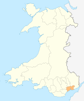
Newport shown within Wales
In the United Kingdom, the term listed building refers to a building or other structure officially designated as being of special architectural, historical, or cultural significance; Grade I structures are those considered to be "buildings of exceptional interest".[1] Listing was begun by a provision in the Town and Country Planning Act 1947. Once listed, strict limitations are imposed on the modifications allowed to a building's structure or fittings. In Wales,[2] the authority for listing under the Planning (Listed Buildings and Conservation Areas) Act 1990[3] rests with Cadw.
Buildings
| Name | Location | Date Listed | Grid Ref.[note 1] Geo-coordinates |
Function | Notes | HB No[note 2] | Image |
|---|---|---|---|---|---|---|---|
| Tredegar House | Coedkernew | 3 March 1952 | ST2882485244 51°33′42″N 3°01′41″W / 51.561590160809°N 3.0281681757608°W |
Country House | Country House set in a landscaped parkland setting on the South side of the M4 at Tredegar. | 2902 | 
|
| Stable Block, Tredegar House | Coedkernew | 3 January 1963 | ST2872285297 51°33′43″N 3°01′47″W / 51.562053717895°N 3.0296501130596°W |
Stables | Located to the NW of Tredegar House, facing onto the cobbled Stable Court, and enclosed to the rear by the Stable Yard. | 2910 | 
|
| Church of St Mary, Nash | Nash | 3 January 1963 | ST3430683661 51°32′53″N 2°56′56″W / 51.548025351766°N 2.9488020139645°W |
Church | In large churchyard in centre of Nash village. | 2936 | 
|
| St Peter's Church, Wentlooge | Wentlooge | 3 January 1963 | ST2679780139 51°30′56″N 3°03′23″W / 51.515436944929°N 3.0563406130036°W |
Church | Located at the centre of Peterstone village, set back from the road, opposite the Six Bells Public House. | 2938 | _Former_church_of_St_Peter_-_geograph.org.uk_-_69908.jpg)
|
| Church of St Thomas, Redwick | Redwick | 3 January 1963 | ST4121484131 51°33′11″N 2°50′57″W / 51.553014474567°N 2.8492697665398°W |
Church | At village centre, opposite village hall and Rose Inn. | 2940 | 
|
| St Woolos' Cathedral | Stow Hill | 26 July 1951 | ST3090787603 51°34′59″N 2°59′55″W / 51.583057068661°N 2.9985889991086°W |
Cathedral church | At top of Stow Hill; in churchyard bounded by Stow Hill and Clifton Road. | 2998 | 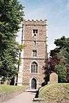
|
| Newport Transporter Bridge including E and W anchor chambers | Pillgwenlly Lliswerry Nash |
5 February 1980 | ST3179486207 51°34′14″N 2°59′08″W / 51.570615°N 2.985517°W |
Transporter Bridge | Spans River Usk between Stephenson Street and Brunel Street. | 17415 17414 3076 |
|
See also
- Listed buildings in Wales
- Grade I listed buildings in Monmouthshire
- Grade I listed buildings in Cardiff
- Grade I listed buildings in Caerphilly
- Grade I listed buildings in Torfaen
- Grade II* listed buildings in Newport
- Scheduled Monuments in Newport
Notes
- ↑ Sometimes known as OSGB36, the grid reference is based on the British national grid reference system used by the Ordnance Survey.
- ↑ The "HB Number" is a unique number assigned to each listed building by Cadw.
References
- ↑ "Buildings & Conservation Areas". Cadw. Retrieved 18 June 2013.
- ↑ "Coflein". online database of RCAHMW. Royal Commission on the Ancient and Historical Monuments of Wales. Retrieved 28 November 2016.
- ↑ "Planning (Listed Buildings and Conservation Areas) Act 1990". The National Archives. Retrieved 18 June 2013.
External links
![]() Media related to Grade I listed buildings in Newport, Wales at Wikimedia Commons
Media related to Grade I listed buildings in Newport, Wales at Wikimedia Commons
This article is issued from Wikipedia - version of the 11/28/2016. The text is available under the Creative Commons Attribution/Share Alike but additional terms may apply for the media files.