Grade I listed buildings in Gwynedd

Gwynedd shown within Wales
In the United Kingdom, the term listed building refers to a building or other structure officially designated as being of special architectural, historical, or cultural significance; Grade I structures are those considered to be "buildings of exceptional interest".[1] Listing was begun by a provision in the Town and Country Planning Act 1947. Once listed, strict limitations are imposed on the modifications allowed to a building's structure or fittings. In Wales,[2] the authority for listing under the Planning (Listed Buildings and Conservation Areas) Act 1990[3] rests with Cadw.
Buildings
| Name | Location | Date Listed | Grid Ref.[note 1] Geo-coordinates |
Function | Notes | HB No[note 2] | Image |
|---|---|---|---|---|---|---|---|
| Cochwillan | Llanllechid | 22 February 1952 | SH6069569416 53°12′13″N 4°05′14″W / 53.20351985981°N 4.0871098688374°W |
House | Situated in low-lying pasture fields at end of short track off the minor road between Bethesda and Tal-y-bont. | 3653 | 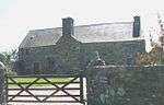
|
| Penrhyn Castle | Llandygai | 3 March 1966 | SH6026671918 53°13′33″N 4°05′41″W / 53.225882014953°N 4.0946246710567°W |
Castle | Set in landscaped grounds of Penrhyn Park in elevated position surrounded by open lawns and some trees at end of long winding drive from Grand Lodge. | 3659 | 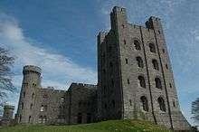
|
| Glynllifon | Llandwrog | 29 April 1952 | SH4566255388 53°04′24″N 4°18′19″W / 53.073364652311°N 4.3052317370628°W |
House | Set in its own extensive grounds on east side of the A499 at Llandwrog; the house is reached by a short drive from the grand lodge. Built on a platform site. | 3684 | 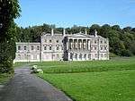
|
| Church of St Beuno, with attached Chapel of St Beuno | Clynnog | 29 May 1968 | SH4145149698 53°01′16″N 4°21′55″W / 53.021024169482°N 4.3652295791478°W |
Church | The parish church is set close to the main Caernarfon to Pwllheli road, in a large graveyard which slopes gently to the N. The chapel stands on the S side of the tower. | 3758 | 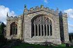
|
| Fort Belan | Llandwrog | 29 May 1968 | SH4403660941 53°07′22″N 4°19′56″W / 53.122765717568°N 4.3321782202911°W |
Fort | Situated 4km south-west of Caernarfon reached along a track to the head of the short peninsula north of Dinas and Morfa Dinlle with dock immediately to east. | 3810 | 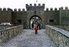
|
| Caernarfon Castle | Caernarfon | 31 March 1983 | SH4779662683 53°08′22″N 4°16′37″W / 53.139501325294°N 4.2768654827618°W |
Castle | At the S end of the town and on the N bank of the Afon Seiont. | 3814 | 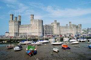
|
| Caernarfon town walls | Caernarfon | 31 March 1983 | SH4793162532 53°08′17″N 4°16′29″W / 53.138183703447°N 4.2747773214531°W |
Town walls | Enclosing the old town on the N side of Caernarfon Castle. | 3815 | 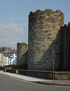
|
| Police Station, including forecourt railings and gate piers | Caernarfon | 10 August 1953 | SH4770862695 53°08′23″N 4°16′41″W / 53.139583903935°N 4.2781856257604°W |
Police station | At the W end of Castle Ditch abutting the Town Wall and directly opposite Caernarfon Castle. | 3827 | .jpg)
|
| County Court (former County Hall) | Caernarfon | 10 August 1953 | SH4773162704 53°08′23″N 4°16′40″W / 53.139671328905°N 4.277846357847°W |
Courthouse | At the junction of Castle Ditch and Shirehall Street, directly opposite Caernarfon Castle. | 3828 | 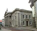
|
| Church of St Mary, Caernarfon | Caernarfon | 10 August 1953 | SH4775562948 53°08′31″N 4°16′39″W / 53.141869766317°N 4.2776038664807°W |
Church | At the N end of the street and incorporated into the Town Wall. | 3857 | 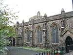
|
| Porth yr Aur (Royal Welsh Yacht Club) | Caernarfon | 8 October 1953 | SH4771162817 53°08′26″N 4°16′42″W / 53.140680544705°N 4.2781988263476°W |
Yacht club | At the W end of High Street and facing The Promenade. | 3861 | 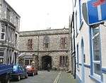
|
| Church of St Peblig | Caernarfon | 8 October 1953 | SH4875062290 53°08′10″N 4°15′45″W / 53.136243721508°N 4.2624300891199°W |
Church | In a walled churchyard set back from the road and to the S of Segontium Roman Fort. | 3881 | 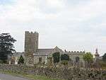
|
| Bangor University Main Building | Bangor | 27 May 1949 | SH5794072337 53°13′44″N 4°07′47″W / 53.229027412542°N 4.1296279532774°W |
University | 3963 | 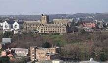
| |
| Bangor Cathedral | Bangor | 27 May 1949 | SH5807872059 53°13′36″N 4°07′39″W / 53.226567225131°N 4.127438326451°W |
Cathedral | In a sloping oval churchyard below the street. | 4027 | 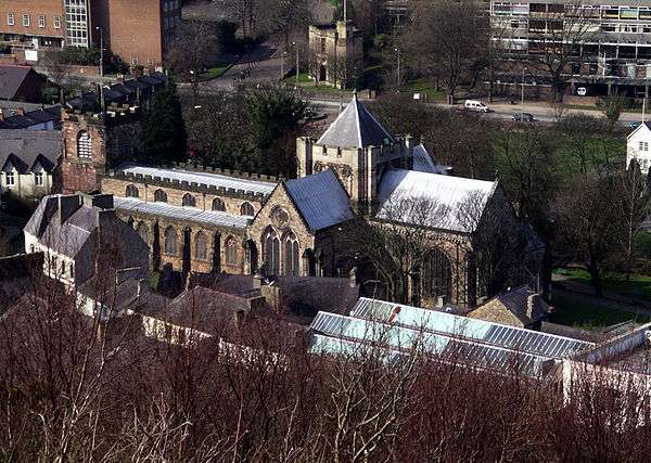
|
| Menai Suspension Bridge | Bangor | 8 February 1988 | SH5561971510 53°13′15″N 4°09′50″W / 53.220971737717°N 4.1639965901374°W |
Bridge | Spanning the Menai Straits to W of the city. | 4049 | 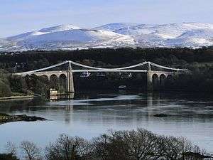
|
| Vaynol Old Hall | Pentir | 22 February 1952 | SH5382969536 53°12′10″N 4°11′24″W / 53.202750224581°N 4.1898810035128°W |
Craft centre | Set in the heart of Vaynol Park, E of Vaynol Hall. Attached outbuildings on the W end, some facing the stable yard. | 4166 | 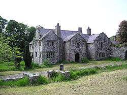
|
| Chapel of St Mary to N of Vaynol Old Hall | Pentir | 22 February 1952 | SH5382169561 53°12′11″N 4°11′24″W / 53.202972576487°N 4.1900121346178°W |
Chapel | The building is located immediately N of the Old Hall, on a raised terrace in the SW corner of the Terraced Gardens. | 4172 | 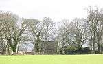
|
| Vaynol Hall | Pentir | 22 February 1952 | SH5369669434 53°12′06″N 4°11′31″W / 53.201797367641°N 4.1918238666841°W |
Country house | Located at the centre of Vaynol Park, SW of the Old Hall, and having gardens adjoining to the SW. | 4173 | _NLW3361483.jpg)
|
| Church of St Hywyn | Aberdaron | 19 October 1971 | SH1732526367 52°48′14″N 4°42′41″W / 52.803820000617°N 4.7113810560122°W |
Church | Situated in Aberdaron village, the graveyard running to the cliff edge. | 4225 | 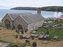
|
| Ruin of Abbey of St Mary | Bardsey Island, Aberdaron | 19 October 1971 | SH1200822172 52°45′52″N 4°47′16″W / 52.764321387251°N 4.7877465961611°W |
Abbey (ruined) | Situated towards the N end of the island in walled churchyard. | 4232 | 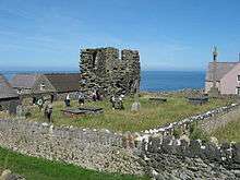
|
| Church of St Iestyn | Llaniestyn, Tudweiliog | 19 October 1971 | SH2697333766 52°52′24″N 4°34′20″W / 52.873456175113°N 4.5723429593327°W |
Church | Situated on the S side of the village centre at Llaniestyn. | 4258 | 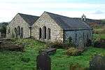
|
| Capel Newydd | Nanhoron, Llanengan | 19 October 1971 | SH2858130919 52°50′54″N 4°32′49″W / 52.848405015008°N 4.5469780820796°W |
Chapel | Situated in field near Ty Bricks reached by lane and track running W from B4413 from point some 700m E of Nanhoron. | 4303 | 
|
| Church of St Engan | Llanengan | 19 October 1971 | SH2939627031 52°48′49″N 4°31′58″W / 52.813748014389°N 4.5328552855759°W |
Church | Situated in Llanengan village in large churchyard just W of road to Llangian. | 4304 | 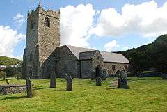
|
| Church of St Cawrdaf, Llannor | Abererch, Llannor | 19 October 1971 | SH3966136582 52°54′10″N 4°23′07″W / 52.902689784226°N 4.3853943819615°W |
Church | The parish church stands in the large churchyard well furnished with slate tombstones, including some C18 ledger stones at the E, at the W end of Abererch village. | 4317 | 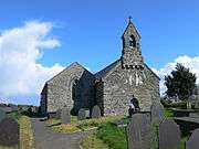
|
| Ffynnon Cybi and associated works | Llanystumdwy | 19 October 1971 | SH4272241276 52°56′45″N 4°20′32″W / 52.945756852863°N 4.3422005276714°W |
Well | The well lies in the narrow valley below the slopes of Garn Bentyrch, and is reached by a footpath from the NE corner of the churchyard, crossing two fields, the second by a causeway. | 4343 | 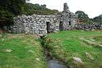
|
| Penarth-fawr | Llanystumdwy | 19 October 1971 | SH4192737675 52°54′47″N 4°21′08″W / 52.913179726817°N 4.352266415218°W |
The house stands on a minor road running N from the A497, W of Pwllheli towards Llanarmon. | 4359 | _-_geograph.org.uk_-_1634648.jpg)
| |
| Church of St Beuno, Pistyll | Pistyll | 19 October 1971 | SH3283342320 52°57′08″N 4°29′23″W / 52.952135634637°N 4.4897687394816°W |
Church | The church is set on a sloping site in a narrow valley below the later hamlet of Pistyll, and below the former road line of the Llithfaen to Nefyn road. | 4374 | 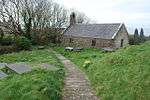
|
| Church of St Gwynhoydl, Tudeweiliog | Tudweiliog | 19 October 1971 | SH2088533236 52°52′00″N 4°39′45″W / 52.866698958961°N 4.6624041341316°W |
Church | Situated some 500m E of the crossroads at Pen-y-graig, NE of a minor road from the crossroads to Pont Llangwnnadl. | 4378 | 
|
| Criccieth Castle | Criccieth | 8 February 1949 | SH4998837731 52°54′58″N 4°13′57″W / 52.915999752114°N 4.232513451147°W |
Castle | 4396 | 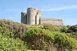
| |
| Capel Peniel | Porthmadog | 30 March 1951 | SH5625939895 52°56′14″N 4°08′25″W / 52.937157505536°N 4.1402792294475°W |
Chapel | Set back from the road at the S end of Tremadog. | 4442 | 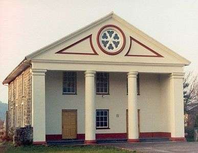
|
| Church of St Cadfan, Tywyn | Tywyn | 30 March 1951 | SH5882200952 52°35′17″N 4°05′07″W / 52.587994925004°N 4.0853823049827°W |
Church | Near the E end of the modern town, in a walled churchyard on the W side of Corbet Square. | 4642 | 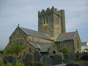
|
| Parish Church of St Derfel, Llandderfel | Llandderfel | 20 October 1966 | SH9815737066 52°55′17″N 3°30′58″W / 52.921341072859°N 3.516246803933°W |
Church | Located within its own walled churchyard at the SW edge of the village, with commanding views down the Dee valley. | 4654 | 
|
| Church of St Mary and St Egryn, Llanegryn | Llanegryn | 17 June 1966 | SH5961805787 52°37′54″N 4°04′33″W / 52.631638395768°N 4.0756948300497°W |
Church | The church is located on a S facing bluff above the confluence of two streams, NNW of the present nucleated village, and is reached by a minor road off the N end of the main village street. | 4729 | .jpg)
|
| Cymer Abbey | Llanelltyd | 17 June 1966 | SH7213419517 52°45′29″N 3°53′46″W / 52.75809802391°N 3.8962164165481°W |
Abbey | Situated near the Afon Mawddach on the opposite bank of the river to Llanelltyd village; accessed via a lane leading NE off the main road. | 4738 | 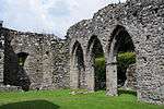
|
| Church of St Celynin, Llangelynin | Llangelynin | 17 June 1966 | SH5712307205 52°38′37″N 4°06′47″W / 52.643724584313°N 4.1131474640353°W |
Church | To the W of and below the A493 in Llangelynin hamlet. The church stands in a rectangular churchyard, and is set into the steeply sloping ground above the railway and sea. | 4751 | .jpg)
|
| Portmeirion Town Hall | Portmeirion, Penrhyndeudraeth | 28 April 1952 | SH5891037133 52°54′47″N 4°05′59″W / 52.913050798466°N 4.0996608457508°W |
Town hall | Facing the Angel and Angel Gates at the western edge of the village group; set against the hill slope. | 4777 | 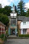
|
| Church of St Tanwg, Llanfair | Llanfair | 30 November 1966 | SH5687328241 52°49′57″N 4°07′34″W / 52.832632794464°N 4.1260198371493°W |
Church | Located at the coast to SSW end of the village of Llandanwg. | 4790 | 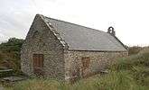
|
| St Brothen's Church, Llanfrothen | Llanfrothen | 30 November 1966 | SH6221941185 52°57′01″N 4°03′08″W / 52.950312555239°N 4.0522080540651°W |
Church | Located on a sloping site at the SW edge of the small village of Llanfrothen; accessed via a footpath leading S from a lane running S to the Village from the B4410 Garreg to Rhyd road; set within a rubble-walled graveyard. | 4804 | 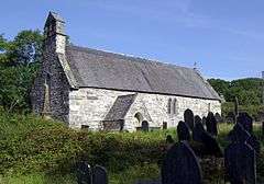
|
| St Mary and St Bodfan Church, Llanaber | Barmouth | 4 March 1951 | SH5993018024 52°44′30″N 4°04′35″W / 52.741653062836°N 4.0762985045146°W |
Church | On a striking site overlooking the sea to the W of the slightly elevated main road; in a large graveyard behind rubble walls, accessed via a stone gabled lychgate. | 4906 | 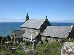
|
| St Mark's Church, Brithdir | Brithdir and Llanfachreth | 26 May 1995 | SH7635718360 52°44′55″N 3°50′00″W / 52.748687431401°N 3.8332371030814°W |
Church | 16008 | 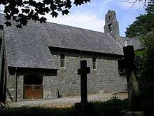
| |
| Capel Jerusalem | Bethesda | 25 April 1997 | SH6245566745 53°10′48″N 4°03′35″W / 53.179985430944°N 4.0596274872271°W |
Chapel | Situated in centre of Bethesda, fronting onto the gardens behind the War Memorial. | 18387 | 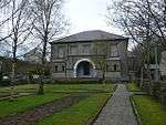
|
| St Baglan's Church, Llanfaglan | Bontnewydd | 29 May 1968 | SH4554460690 53°07′15″N 4°18′34″W / 53.120951378836°N 4.3095419441351°W |
Church | Situated NW of Llanfaglan, in an isolated situation in a field some 150m E of the minor road which runs N - S along the edge of the Afon Gwyrfai estuary. | 18619 | 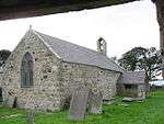
|
| Dolbadarn Castle | Llanberis | 28 May 1999 | SH5860359791 53°06′59″N 4°06′51″W / 53.116507273719°N 4.1141529435627°W |
Castle | Situated on a natural rock outcrop in a strategic position at the north-west end of Llyn Peris, the castle forms a prominent feature in the landscape. | 21854 | 
|
| Dinorwic Slate Quarry Workshops (National Slate Museum Buildings) | Llanddeiniolen | 11 April 1999 | SH5855060280 53°07′15″N 4°06′55″W / 53.120885793033°N 4.1151599699246°W |
Quarry workshops | Located at the south-east end of Llyn Padarn to the east of Llanberis, the quarry workshops sit at the foot of the vast workings of the former Dinorwic Slate Quarry; the immediately surrounding land is now largely used as car parking for the museum. | 22656 | 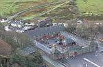
|
| Harlech Castle | Harlech | 21 June 2001 | SH5811031240 52°51′36″N 4°06′32″W / 52.859901568961°N 4.1089772533429°W |
Castle | Imposingly sited in the centre of the town with dramatic views across Tremadog Bay and towards Snowdonia. | 25500 | 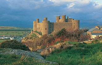 |
See also
Notes
- ↑ Sometimes known as OSGB36, the grid reference is based on the British national grid reference system used by the Ordnance Survey.
- ↑ The "HB Number" is a unique number assigned to each listed building by Cadw.
References
- ↑ "Buildings & Conservation Areas". Cadw. Retrieved 18 June 2013.
- ↑ "Coflein". online database of RCAHMW. Royal Commission on the Ancient and Historical Monuments of Wales. Retrieved 28 November 2016.
- ↑ "Planning (Listed Buildings and Conservation Areas) Act 1990". The National Archives. Retrieved 18 June 2013.
External links
![]() Media related to Grade I listed buildings in Gwynedd at Wikimedia Commons
Media related to Grade I listed buildings in Gwynedd at Wikimedia Commons
This article is issued from Wikipedia - version of the 11/28/2016. The text is available under the Creative Commons Attribution/Share Alike but additional terms may apply for the media files.