Grade II* listed buildings in Coventry

There are 25 Grade II* listed buildings in the City of Coventry. In the United Kingdom, a listed building is a building or structure of special historical or architectural importance. These buildings are legally protected from demolition, as well as from any extensions or alterations that would adversely affect the building's character or destroy historic features. Listed buildings are divided into three categories—Grade I buildings are buildings of "exceptional" interest, Grade II buildings are buildings of special interest, and Grade II* buildings are Grade II buildings that are of particular interest.[1] Coventry is an ancient city and a metropolitan borough in the West Midlands of England. The city's history dates back to at least the 11th century (CE), and it was a thriving centre of commerce in mediaeval times.[2]
The oldest building on this list is St Lawrence's Church—originally built in the 14th century[3]—and the newest are the Houses for Visiting Mathematicians at the University of Warwick, completed in 1969.[4] Sir William Reid Dick's sculpture of ancient Coventry noblewoman Lady Godiva is the city's only other Grade II* listed building from the 20th century.[5] There are no Grade II* listed buildings in Coventry from the 13th, 17th, or 21st centuries, but there is at least one from every other century between 1100 and 2000. Of those, more buildings (six) date to the 14th century than any other, though five were built in the 16th century. The construction date of two buildings—the Mediaeval Stone Building on Much Park Street and the basement of the former Old Starr Inn—are not known, though both date from the Middle Ages.[6][7]
Many of the buildings have changed use over their lifetime. Five are or were churches or chapels, of which four remain places of worship. The fifth, Christchurch Steeple, was originally part of a 13th-century friary and served as a church until it was mostly destroyed in World War II bombing, which left only the steeple.[8] The building is now a popular bar.[9] Four other Grade II* listed buildings in the city are pubs or bars, or were at some point in their history.
Grade II* listed buildings
| Name | Location | Type | Completed [note 1] | Date designated | Grid ref.[note 2] Geo-coordinates | Notes | Entry number [note 3] | Image |
|---|---|---|---|---|---|---|---|---|
| Draper's Hall | Bayley Lane, City Centre | Livery Hall | 1832 | 10 May 1957 | SP3363178951 52°24′27″N 1°30′25″W / 52.407537°N 1.50705°W |
Neoclassical 19th-century hall designed by H W Hutchinson and T Rickman. Built mainly with ashlar, the hall was built in 1832 with addition in 1964. The building is a single storey with a fluted cornice and elaborate exterior decoration. Drapers' Hall is described as "the most interesting building of its period in the City."[10] | 1076660 | 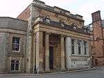 |
| Number 22 (the Cottage) | Bayley Lane | Timber Framed House | Circa 1500 | 5 February 1955 | SP3356378975 52°24′28″N 1°30′29″W / 52.407757°N 1.508047°W |
The Cottage is a timber-frame building with plaster infilling and brickwork on the ground floor. The first floor oversails the ground floor. The ground floor was converted to a shop in the 19th century and the shop window survives. Part of a group with St Mary's Guildhall (Grade I) and Number 21 (Grade II).[11] | 1342896 |  |
| Number 65 (Stone House) | Birmingham Road, Allesley | House | Circa 1557 | 5 February 1955 | SP3011880596 52°25′21″N 1°33′31″W / 52.422529°N 1.558542°W |
Number 65 is a large sandstone house, built in the 16th century for John Milward. The central porch contains several features of particular interest, including pilasters and a flattened ogee arch.[12] | 1076663 |  |
| Lady Godiva Statue | Broadgate, City Centre | Statue | 1949 | 15 April 1998 | SP3340379003 52°24′29″N 1°30′37″W / 52.408018°N 1.510396°W |
Bronze statue on stone base sculpted by Sir William Reid Dick. Commissioned by William Bassett-Green and donated to the city in 1949 to boost morale in post-war Coventry. The statue was rotated 90° in 1990.[5] | 1031589 |  |
| County Hall | Cuckoo Lane, City Centre | County Court | 18th century | 24 June 1974 | SP3352278997 52°24′29″N 1°30′31″W / 52.407957°N 1.508648°W |
Originally the county court, County Hall is an 18th-century red-brick building with stone dressings on the front. Quoins are built into the sides and corners of the building. The second story has pilasters to the sides and cornice at the top of the second storey. The building is now used as a bar.[13][14] | 1076642 |  |
| Medieval Basement on Site of Old Star Inn | Earl Street, City Centre | Basement | Late mediaeval | 5 February 1955 | SP3365378869 52°24′24″N 1°30′24″W / 52.406799°N 1.506735°W |
Late mediaeval ashlar basement. The site was formerly occupied by the Old Star Inn, but is currently used by Coventry City Council. The basement consists of four ribbed vaults, whose ribs rest on corbels.[6] | 1115642 | 
|
| Bird Grove House | George Elliot Road, Foleshill | House | 19th century | 24 June 1974 | SP3374680340 52°25′12″N 1°30′19″W / 52.420017°N 1.50522°W |
A two-storey stucco house with slate roof. From 1841 to 1849, the building was the residence of novelist George Eliot.[15] | 1076646 |
|
| Houses for Visiting Mathematicians | Gibbet Hill Road (University of Warwick) | Apartment | 1970 | 7 June 2007 | 49°46′01″N 7°33′26″W / 49.766806°N 7.55716°W | A set of five houses arranged around the points of a compass. They were built between 1968 and 1969 for academics attending mathematics conferences at the University of Warwick. The houses are brick, with timber window surrounds and flat felt roofs. The set won the Royal Institute of British Architects Award in 1970.[4] | 1392017 |  |
| Golden Cross Inn | Hay Lane, City Centre | Jettied House | Circa 1583 | 5 February 1955 | SP3353678972 52°24′28″N 1°30′30″W / 52.407732°N 1.508444°W |
The Golden Cross is a 16th-century pub that was reputedly built around 1583 but has since undergone significant restoration. The building is three storeys tall and timber-framed with plaster infilling, while the roof is tile with brick chimney stacks. The oversailing of the upper floors is of particular interest.[16] | 1116277 |  |
| Bond's Hospital | Hill Street, City Centre | Hospital | Early 16th century | 24 June 1974 | SP3302379131 52°24′33″N 1°30′57″W / 52.409192°N 1.51597°W |
Almshouse founded by the will of Thomas Bond, who died in 1506. Bond's Hospital was originally built in the 16th century, but underwent significant restoration work in the 19th century. The building is mainly timber frame but contains more modern brickwork and ashlar. Of particular interest are the large oriel windows on the first floor.[17] | 1076615 |  |
| Number 7 | Little Park Street, City Centre | House | 18th century | 5 February 1955 | SP3352078853 52°24′24″N 1°30′31″W / 52.406663°N 1.508691°W |
One of two Georgian townhouses on Little Park Street (the other being Kirby House, also Grade II* listed). The building is three storeys and stands on a large plinth. The exterior is decorated with six fluted Corinthian pilasters, over which an entablature projects forward on the second storey. The pilasters continue on the third storey, but are plain. The central door is flanked by two further pilasters. The building is now a bar.[18] | 1145820 |  |
| Number 16 (Kirby House) | Little Park Street, City Centre | House | Circa 1700 | 5 February 1955 | SP3351178795 52°24′22″N 1°30′32″W / 52.406142°N 1.508829°W |
One of two Georgian townhouses on Little Park Street (the other being Number 7, also Grade II* listed). The house is red brick, with stucco at the bottom of the ground floor, a cornice, and a tiled roof behind a parapet. The large doorway contains a fanlight and is flanked by two columns. The exterior is decorated with four pilasters. The listing includes the railings to the forecourt, which were added in the 19th century.[19] | 1342916 |  |
| Precinct wall at the Charterhouse | London Road | Precinct Wall | 14th century | 24 June 1974 | SP3452878293 52°24′06″N 1°29′38″W / 52.401566°N 1.493932°W |
Mediaeval red sandstone wall with ashlar face. Part of a group with the Charterhouse (Grade I) and the Coach House at the Charterhouse (Grade II).[20] | 1342917 | 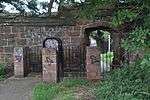 |
| Non-conformist Chapel | London Road Cemetery | Nonconformist Chapel | 1847 | 24 June 1974 | SP3419378021 52°23′57″N 1°29′56″W / 52.399142°N 1.498884°W |
An ashlar classical temple with two storeys and a basement, supported by piers on the corners. The chapel has two large fluted columns at the front with a large portico between them. The building was abandoned after it was damaged during the Second World War. It has not been used since, nor has any restoration been undertaken, and the state of the building is described by English Heritage as "dilapidated".[21] | 1076624 | 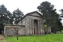 |
| Cheylesmore Manor | Manor House Drive, City Centre | Manor House | 16th century | 5 February 1955 | SP3335878645 52°24′17″N 1°30′40″W / 52.404803°N 1.511093°W |
The building serve as the gatehouse for the much older manor and is now all that remains of it. It is timber-framed with plaster infilling and stonework on the ground floor. The interior has been significantly rebuilt. The central carriageway contains four arched doorways (now blocked). The building is now used as the city's register office.[22][23] | 1299033 |  |
| Numbers 36 & 37 (Whitefriars Gate) | Much Park Street, City Centre | House | 14th century | 5 February 1955 | SP3376878664 52°24′18″N 1°30′18″W / 52.404949°N 1.505065°W |
Timber frame and sandstone house, originally a gatehouse to a Carmelite priory. The archway leads to Whitefriars Lane and from there to the surviving fragments of the priory. Later repairs were made with red brick.[24] | 1087114 | 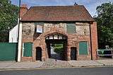 |
| Christchurch Steeple (Greyfriars) | New Union Street, City Centre | Church | 14th century | 5 February 1955 | SP3332878751 52°24′21″N 1°30′41″W / 52.405758°N 1.511524°W |
The steeple was originally part of a 13th-century Franciscan friary. The church was rebuilt in the 19th century, but the main church building was destroyed in an air raid in the Second World War, leaving just the steeple, which is now a bar.[8][9][25] | 1076628 | 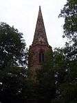 |
| Old Blue Coat School | Priory Row, City Centre | School | 19th century | 5 February 1955 | SP3349779129 52°24′33″N 1°30′32″W / 52.409145°N 1.509002°W |
19th-century stone building in the style of a French château. The building consists of two wings, of which the left is two storeys and the right three storeys, each with a tower. The towers are supported by octagonal buttresses and are the only above-ground remains of the monastic church which originally occupied the site (there are further remains in what is now the basement). The building overlooks the ancient ruins of St. Mary's Priory and Cathedral, which are Grade I listed. The school itself moved in 1964.[26] | 1076589 |  |
| Numbers 119 to 123 (consecutive) | Upper Spon Street, Spon End | House | 15th century | 7 March 1991 | SP3258179057 52°24′31″N 1°31′21″W / 52.408553°N 1.522474°W |
A row of 15th-century houses with later additions and restorations. The buildings are timber-framed, but alterations are cement rendered or brick. The buildings were originally the property of Coventry Priory and were acquired by the Coventry Mercers' Guild in the 16th century. The buildings were sold in the 17th century and successive owners have used them as private residences or businesses. Number 123 was formerly the Black Swan pub.[27] | 1226523 |  |
| Church of St Michael | Walsgrave Road, Stoke | Church | 14th century | 5 February 1955 | SP3580879459 52°24′43″N 1°28′30″W / 52.411966°N 1.474995°W |
Mediaeval church with later additions. The tower was added later in the 14th or 15th century and an extension was built in the late 19th century in the original 14th-century style.[28] | 1076574 | 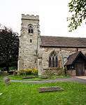 |
| Church of St Lawrence | Old Church Road, Foleshill | Church | 12th century | 5 February 1955 | SP3535582577 52°26′24″N 1°28′53″W / 52.440025°N 1.481326°W |
Mediaeval church with later additions. The nave roof was rebuilt in 1614, the nave itself underwent significant restoration in 1784, and the chancel was rebuilt in 1792. Other work was undertaken at different times throughout the 19th and 20th centuries. The church was bombed in an air raid in October 1940 and the nave was again rebuilt and other restoration work undertaken. The church re-opened in 1942. The surviving parts of the mediaeval church, and the variety of different materials used in successive rebuilds and restorations are of particular interest.[3] | 1335825 |  |
| Mediaeval Stone Building | Much Park Street, City Centre | Building | Late 13th or early 14th century | 5 February 1955 | SP3375578728 52°24′20″N 1°30′19″W / 52.405525°N 1.50525°W |
Unidentified rectangular red sandstone building. The roof and one wall have been lost, but the majority of the other three walls survive, one of which includes a pointed arched window. The remains were uncovered by a bomb dropped during a World War II air raid.[7] | 1342921 | 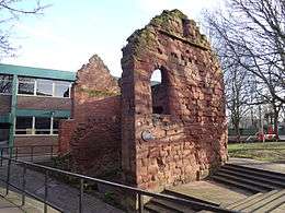 |
| Church of St Mary the Virgin | Hall Lane, Walsgrave | Church | 1300 | 5 February 1955 | SP3790680883 52°25′29″N 1°26′38″W / 52.424626°N 1.443992°W |
St Mary's was first built in 1300 but significantly rebuilt later in the 13th or 14th century and again in the 19th and 20th centuries. The church consists of a nave with two aisles and a tower, which was added in the 15th century. A large extension (not of special interest) was added in the 1980s.[29] | 1115404 |  |
| War Memorial in Coventry War Memorial Park | Coventry | War Memorial | 1925-1927 | 8 January 2013 | SP3285177418 52°23′38″N 1°31′07″W / 52.393803°N 1.518665°W |
1410358 |  | |
| Stoney Road Allotments | London Road Cemetery | Pleasure gardens | 19th century | 21 March 2001 | 49°46′01″N 7°33′26″W / 49.766806°N 7.55716°W | A collection of allotments and pleasure gardens to the south of Coventry city centre, including summerhouses and other structures built on individual plots.[30] | 1001494 | |
See also
| Wikimedia Commons has media related to Grade II* listed buildings in Coventry. |
- History of Coventry
- Scheduled Ancient Monuments in Coventry
- Grade I listed buildings in Coventry
- Grade II* listed buildings in the West Midlands
Notes
- ↑ The date given is the date used by Historic England as significant for the initial building or that of an important part in the structure's description.
- ↑ Sometimes known as OSGB36, the grid reference is based on the British national grid reference system used by the Ordnance Survey.
- ↑ The "List Entry Number" is a unique number assigned to each listed building and scheduled monument by Historic England.
References
- ↑ "Statutory List of Buildings of Special Architectural or Historic Interest". Coventry City Council. Retrieved 24 August 2012.
- ↑ Soden, Ian (2005). Coventry: The Hidden History. Tempus Publishing Ltd. pp. 7–8. ISBN 9780752433455.
- 1 2 "Church of St Lawrence". National Heritage List for England. English Heritage. Retrieved 10 October 2012.
- 1 2 "Houses for Visiting Mathematicians, University of Warwick". National Heritage List for England. English Heritage. Retrieved 10 October 2012.
- 1 2 "Lady Godiva Statue". National Heritage List for England. English Heritage. Retrieved 9 October 2012.
- 1 2 "Medieval Basement on Site of Old Star Inn". National Heritage List for England. English Heritage. Retrieved 10 October 2012.
- 1 2 "Medieval Stone Building". National Heritage List for England. English Heritage. Retrieved 10 October 2012.
- 1 2 Page, William (editor) (1908). "Friaries: Franciscan friars of Coventry". A History of the County of Warwick: Volume 2. Institute of Historical Research. Retrieved 9 October 2012.
- 1 2 Bagot, Martin (14 February 2011). "Coventry's Inspire cafe bar in UK Top 50 coolest nightspots". Coventry Telegraph. Trinity Mirror Midlands. Retrieved 9 October 2012.
- ↑ "Draper's Hall". National Heritage List for England. English Heritage. Retrieved 9 October 2012.
- ↑ "The Cottage". National Heritage List for England. English Heritage. Retrieved 10 October 2012.
- ↑ "No name for this Entry (65 Birmingham Road)". National Heritage List for England. English Heritage. Retrieved 9 October 2012.
- ↑ Thomas, Helen (5 January 2012). "New bar in former Coventry County Hall building granted 4am licence". Coventry Telegraph. Trinity Mirror Midlands. Retrieved 9 October 2012.
- ↑ "County Hall". National Heritage List for England. English Heritage. Retrieved 9 October 2012.
- ↑ "Bird Grove House". National Heritage List for England. English Heritage. Retrieved 9 October 2012.
- ↑ "No name for this Entry (Golden Cross)". National Heritage List for England. English Heritage. Retrieved 10 October 2012.
- ↑ "Bonds Hospital". National Heritage List for England. English Heritage. Retrieved 9 October 2012.
- ↑ "No name for this Entry (7 Little Park Street)". National Heritage List for England. English Heritage. Retrieved 10 October 2012.
- ↑ "Kirby House and Forecourt Railings". National Heritage List for England. English Heritage. Retrieved 10 October 2012.
- ↑ "Medieval Precinct Wall to the Charterhouse". National Heritage List for England. English Heritage. Retrieved 10 October 2012.
- ↑ "Non Conformist Chapel to the Cemetery". National Heritage List for England. English Heritage. Retrieved 9 October 2012.
- ↑ "Cheylesmore Manor". Visit Coventry and Warwickshire. Retrieved 10 October 2012.
- ↑ "Cheylesmore Manor". National Heritage List for England. English Heritage. Retrieved 10 October 2012.
- ↑ "Number 36 and Number 37 and Archway In Between (Whitefriars Gate)". National Heritage List for England. English Heritage. Retrieved 9 October 2012.
- ↑ "Christchurch Steeple". National Heritage List for England. English Heritage. Retrieved 9 October 2012.
- ↑ "Blue Coat School". National Heritage List for England. English Heritage. Retrieved 9 October 2012.
- ↑ "No name for this Entry (119–123 Upper Spon Street)". National Heritage List for England. English Heritage. Retrieved 10 October 2012.
- ↑ "Church of St Michael". National Heritage List for England. English Heritage. Retrieved 9 October 2012.
- ↑ "Church of St Mary the Virgin". National Heritage List for England. English Heritage. Retrieved 10 October 2012.
- ↑ "Stoney Road Allotments". National Heritage List for England. English Heritage. Retrieved 10 October 2012.