Grüningen
| Grüningen | ||
|---|---|---|
 | ||
| ||
 Grüningen | ||
|
Location of Grüningen  | ||
| Coordinates: 47°17′N 8°46′E / 47.283°N 8.767°ECoordinates: 47°17′N 8°46′E / 47.283°N 8.767°E | ||
| Country | Switzerland | |
| Canton | Zürich | |
| District | Hinwil | |
| Area[1] | ||
| • Total | 8.79 km2 (3.39 sq mi) | |
| Elevation | 502 m (1,647 ft) | |
| Population (Dec 2015[2]) | ||
| • Total | 3,358 | |
| • Density | 380/km2 (990/sq mi) | |
| Postal code | 8627 | |
| SFOS number | 0116 | |
| Surrounded by | Gossau, Bubikon, Hombrechtikon, Oetwil am See, Egg | |
| Website |
www SFSO statistics | |

Grüningen is a village in the district of Hinwil in the canton of Zürich in Switzerland.
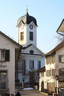
In 1976, Grüningen received the Wakker Prize for the development and preservation of its architectural heritage.
History
Grüningen is first mentioned in 1243 as apud Gruningin.[3] The village of Itzikon was first mentioned in 837 as in Izinheimo and Binzikon was mentioned in 854 as in willa Pinuzzinhovun.
In the Strangenholz area of the municipality, burial mounds from a Hallstatt era population have been found. The exact date that the area was settled is not known, but based on mentions of Itzikon and Binzikon from the 9th Century, settlement must have occurred in the 8th Century.
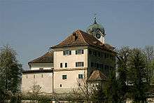
In the early Middle Ages, the area belonged to the counts of Rapperswil. It then came into the possession of the Abbey of Saint Gall, which granted it in the early 13th century as a fief to the powerful House of Regensberg, who probably built the little town and castle. Wasteful living as well as wars against Zürich and against the House of Habsburg forced those of Regensberg to sell off many of their possessions including the castle and little town of Grüningen, which came again into the possession of the Abbey of Saint Gall, and were bought by Rudolf of Habsburg in the year 1273.[4]
In 1374 the domain of Grüningen was pawned to the Gessler family of Maienberg. In 1408 the brothers Hermann and Wilhelm Gessler sold these rights to the town of Zürich.[5]
Notable persons
- Hermann Gessler, ruler in Grüningen, is the historic person on whom the person of Hermann Gessler in the Wilhelm Tell legend is probably based.
- Conrad Grebel, co-founder of the Swiss Brethren movement.
Geography
Grüningen has an area of 8.8 km2 (3.4 sq mi). Of this area, 62.5% is used for agricultural purposes, while 20.5% is forested. Of the rest of the land, 14.6% is settled (buildings or roads) and the remainder (2.5%) is non-productive (rivers, glaciers or mountains).[6] In 1996 housing and buildings made up 10.6% of the total area, while transportation infrastructure made up the rest (4%).[7] Of the total unproductive area, water (streams and lakes) made up 0.5% of the area. As of 2007 9.2% of the total municipal area was undergoing some type of construction.[7]
The municipality is located in the Zürcher Oberland and includes the villages and hamlets of Grüningen, Itzikon, Binzikon, Bächelsrüti, Adeltshausen and Holzhausen as well as scattered individual houses.
Wakker prize
The Wakker prize was awarded to Grüningen for the efforts that the Heimatschutzgesellschaft (Swiss heritage society) put into maintaining the historic appearance of the village. Their efforts included watching over any changes that were made to the city and presenting suggestions for improvement. They developed and staffed a local museum, presented cultural events and published information about the village's heritage.[8]
Demographics


Grüningen has a population (as of 31 December 2015) of 3,358.[2] As of 2007, 11.1% of the population was made up of foreign nationals. As of 2008 the gender distribution of the population was 49.6% male and 50.4% female. Over the last 10 years the population has grown at a rate of 4.4%. Most of the population (as of 2000) speaks German (92.0%), with Italian being second most common ( 1.9%) and English being third ( 1.3%).
In the 2007 election the most popular party was the SVP which received 43.5% of the vote. The next three most popular parties were the SPS (12.3%), the FDP (11.7%) and the CSP (11%).
The age distribution of the population (as of 2000) is children and teenagers (0–19 years old) make up 24.4% of the population, while adults (20–64 years old) make up 61.8% and seniors (over 64 years old) make up 13.8%. The entire Swiss population is generally well educated. In Grüningen about 75.2% of the population (between age 25-64) have completed either non-mandatory upper secondary education or additional higher education (either university or a Fachhochschule). There are 1135 households in Grüningen.[7]
Grüningen has an unemployment rate of 1.36%. As of 2005, there were 136 people employed in the primary economic sector and about 49 businesses involved in this sector. 300 people are employed in the secondary sector and there are 36 businesses in this sector. 803 people are employed in the tertiary sector, with 88 businesses in this sector.[6] As of 2007 46% of the working population were employed full-time, and 54% were employed part-time.[7]
As of 2008 there were 663 Catholics and 1573 Protestants in Grüningen. In the 2000 census, religion was broken down into several smaller categories. From the 2000 census, 57.7% were some type of Protestant, with 53.3% belonging to the Swiss Reformed Church and 4.4% belonging to other Protestant churches. 25.7% of the population were Catholic. Of the rest of the population, 0% were Muslim, 3% belonged to another religion (not listed), 2.7% did not give a religion, and 10.2% were atheist or agnostic.[7]
The historical population is given in the following table:[3][9]
| year | population |
|---|---|
| 1467 | 38 Households |
| 1634 | 674 |
| 1739 | 1,040 |
| 1850 | 1,695 |
| 1900 | 1,207 |
| 1950 | 1,450 |
| 1990 | 2,597 |
| 2000 | 2,811 |
| 2010 | 3,165 |
Climate
Grüningen has an average of 144.3 days of rain per year and on average receives 1,328 mm (52.3 in) of precipitation. The wettest month is August during which time Grüningen receives an average of 162 mm (6.4 in) of precipitation. During the wettest month, there is precipitation for an average of 14.3 days.[10]
References
- ↑ Arealstatistik Standard - Gemeindedaten nach 4 Hauptbereichen
- 1 2 Canton of Zurich Statistical Office (German) accessed 27 April 2016
- 1 2 Grüningen in German, French and Italian in the online Historical Dictionary of Switzerland.
- ↑ Altdorfer, Werner (1987). Rund um den Bachtel - Heimatkundliches aus dem Zürcher Oberland (in German). Wetzikon: Buchverlang der Druckerei Wetzikon AG. ISBN 978-3-85981138-6.
- ↑ Grüningen Vogtei in German, French and Italian in the online Historical Dictionary of Switzerland.
- 1 2 Swiss Federal Statistical Office accessed 6 August 2009
- 1 2 3 4 5 Statistics Zürich (German) accessed 4 August 2009
- ↑ Wakker Prize (German) accessed 6 August 2009
- ↑ Grüningen Today (German) accessed 20 May 2011
- ↑ "Temperature and Precipitation Average Values-Table, 1961-1990" (in German, French, and Italian). Federal Office of Meteorology and Climatology - MeteoSwiss. Retrieved 8 May 2009., the weather station elevation is 495 metres (1,624 feet) above sea level.
External links
![]() Media related to Grüningen at Wikimedia Commons
Media related to Grüningen at Wikimedia Commons
- Official website (German)
- Grüningen in German, French and Italian in the online Historical Dictionary of Switzerland.
- Grüningen Vogtei in German, French and Italian in the online Historical Dictionary of Switzerland.