Gosthani River


Gosthani River is an east flowing river in Andhra Pradesh, India that flows from the Ananthagiri Hills of the Eastern Ghats into the Bay of Bengal.
Course
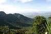
The Gosthani rises in the Ananthagiri Hills of the Eastern Ghats and flows through the Borra Caves which lie near its source. It flows for 120 km before joining the Bay of Bengal through an estuary near Bheemunipatnam.[1][2] The river basin drains the two coastal districts of Vizianagaram and Visakhapatnam. The basin exhibits a subdendritic and dendritic pattern of drainage.[3] The Gosthani's is a minor river basin with a total drainage area of less than 2000 km2.[4] Much of the basin is covered by khondalite group of gneissic rocks. About 3% of the total area of the Visakhapatnam district is under the Gosthani basin.[5] The river is rainfed, receiving an average rainfall of 110 cm most of which comes from the south-west monsoon.[3] There are several red sand hills near Bheemunipatnam, where the Gosthani joins the Bay of Bengal, which are reminiscent of the Chambal ravines. These are thought to have been formed six millennia ago due to shifts in the river's course following tectonic activity.[6] The river joins the Bay of Bengal at Bhimli where it forms an estuary.[7]
Historic places
Bheemunipatnam or Bhimli, located at the confluence of the river with the Bay of Bengal was one of the earliest outposts of the Dutch East India Company in India and there are many monuments from that era in the town.[8][9] Ancient Buddhist settlements at Pavuralakonda, near Bhimli and at Gudiwada have been excavated. The river is thought to have provided the inhabitants with drinking water and the estuary at Bhimli facilitated sea-borne trade.[7][10]
Waterworks

The Gosthani's waters are diverted for agricultural and industrial purposes and the river is the chief source of drinking water to the cities of Vizianagaram and Visakhapatnam.[3] Several infiltration wells have been sunk on the Gosthani's riverbed to extract water especially during the summer months.[11] The Thatipudi Reservoir Project with a capacity of 3 TMC was built on the Gosthani during 1963-68 and is located in the Gantyada Mandal of the Vizianagaram district. It irrigates 15,378 acres (62.23 km2) of land in Vizianagaram district and provides drinking water to Visakhapatnam.[12] The Chaparai Falls, situated in a verdant valley, is on the Gosthani river.[13] The Visakhapatnam to Srikakulam leg of the Golden Quadrilateral Highway crosses the Gosthani at Tagarapuvalasa where a new bridge was inaugurated in 2003.[14]
Environmental issues
The decision to grant bauxite mining leases in Visakhapatnam by the Government of Andhra Pradesh has drawn criticism from local people, activists and the Central Government who fear severe environmental damage along the source and catchment areas of the river due to the mining.[15][16] The decision to lease out the Gosthani's river bed to a private company for the extraction of groundwater through the sinking of borewells is thought to have had serious consequences on the water table and water security of over 100,000 people in the region.[17]
Image Gallery
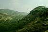
 Gosthani River during monsoon near Borra Caves
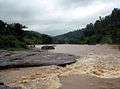
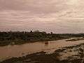 River Gosthani at Bhimasingi
 River Gosthani at Thagarapuvalasa
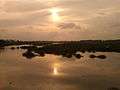 Sunset over River Gosthani at Thagarapuvalasa
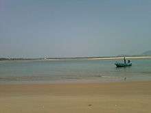 River Gosthani at Bheemunipatnam
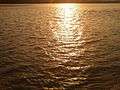 Sunset reflections over River Gosthani
 Boat in River Gosthani at Bheemunipatnam beach
References
- ↑ Ganesh, B (April 2013). "Studies on textural characteristics of sediments from Gosthani River Estuary - Bheemunipatnam, A.P., East Coast of India" (PDF). Journal of the Indian Geophysical Union. 17 (2): 139. Retrieved 30 June 2013.
- ↑ "A journey into the heart of nature". The Hindu Businessline. 10 April 2013. Retrieved 27 June 2013.
- 1 2 3 Rao. K, Nageswara (2010). "Morphometric Analysis of Gostani River Basin in Andhra Pradesh State, India Using Spatial Information Technology" (PDF). International Journal of Geomatics and Geosciences. 1 (2): 179–182. Retrieved 27 June 2013.
- ↑ Bay of Bengal Large Marine Ecosystem Project - Country Report on Pollution (India) (PDF). 2011. p. 18.
- ↑ "IRRIGATION PROFILE: VISAKHAPATNAM DISTRICT". Government of Andhra Pradesh. Retrieved 27 June 2013.
- ↑ "Protect the landmark for the future". The Hindu. 28 March 2009. Retrieved 27 June 2013.
- 1 2 Indian Archaeology 2000-2001 - A Review (PDF). New Delhi: Archaeological Survey of India. 2006. pp. 2, 3.
- ↑ "Fifteen decades of glory". The Hindu. 25 September 2010. Retrieved 27 June 2013.
- ↑ "Andhra's English past". Deccan Herald. 19 February 2012. Retrieved 27 June 2013.
- ↑ "Evidence of Buddhist site found". The Hindu. October 9, 2012. Retrieved 27 June 2013.
- ↑ "Visakhapatnam's water problems may continue". The Hindu. 12 April 2006. Retrieved 27 June 2013.
- ↑ Irrigation profile of Vizianagaram district. Thatipudi Reservoir Project
- ↑ "Green valley of delight". Deccan Herald. 14 April 2013. Retrieved 27 June 2013.
- ↑ "New bridges to be inaugurated in AP". The Hindu Businessline. 11 December 2003. Retrieved 27 June 2013.
- ↑ "Death Of Red Earth Foretold". Outlook. 9 April 2012. Retrieved 27 June 2013.
- ↑ "Tribal minister Kishore Chandra Deo to urge governors to use special powers to cancel mining leases in tribal areas". Times of India. 11 October 2012. Retrieved 27 June 2013.
- ↑ "Beyond the last frontier". Frontline. 21 (19). 11–24 September 2004. Retrieved 27 June 2013.
External links
| Wikimedia Commons has media related to Gosthani River. |