Glorioso Islands
| Glorioso Islands Îles Glorieuses |
||||
|---|---|---|---|---|
|
||||
| Motto: Liberté, égalité, fraternité "Liberty, Equality, Brotherhood" |
||||
| Anthem: La Marseillaise | ||||
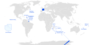
 Location of the Scattered islands in the Indian Ocean.
KM=Comoros MG=Madagascar MU=Mauritius MZ=Mozambique RE=Réunion YT=Mayotte |
||||
The Glorieuses or Glorioso Islands (French: Îles Glorieuses or officially also Archipel des Glorieuses) are a group of French islands and rocks totalling 5 square kilometres (1,200 acres), at 11°33′S 47°20′E / 11.550°S 47.333°ECoordinates: 11°33′S 47°20′E / 11.550°S 47.333°E, in the Indian Ocean, about 160 kilometres (99 mi) northwest of Madagascar. In 2012, France founded parc naturel marin des Glorieuses, a marine protected area, to preserve the endangered flora and fauna of the islands. The Glorieuses have an Exclusive Economic Zone (EEZ) of 48,350 square kilometres (18,670 sq mi). There are anchorages offshore, and Grande Glorieuse has a 1,300-metre (4,300 ft) long airstrip.
The archipelago consists of two islands, Grande Glorieuse (11°34′46.54″S 47°17′54.14″E / 11.5795944°S 47.2983722°E) and Île du Lys, as well as eight rock islets (Roches Vertes): Wreck Rock (11°30′45.19″S 47°22′54.17″E / 11.5125528°S 47.3817139°E), South Rock (11°35′43.76″S 47°18′6.66″E / 11.5954889°S 47.3018500°E) and Verte Rocks (11°34′15.63″S 47°19′54.18″E / 11.5710083°S 47.3317167°E) and three others that are unnamed. They form part of a coral reef and lagoon. Grande Glorieuses is roughly circular and measures about 3 kilometres (1.9 mi) across. It is thickly vegetated, mainly by the remains of a coconut plantation and casuarina trees.
Île du Lys, located at 11°30′59.35″S 47°22′36.02″E / 11.5164861°S 47.3766722°E about 8 kilometres (5.0 mi) northeast of Grande Glorieuses, is about 600 metres (2,000 ft) long and consists of sand dunes and scrub with some mangroves. It was formerly quarried for phosphate (guano).
The climate is tropical and the terrain is low and flat, varying from sea level to 12 metres (39 ft). Île de Lys in particular is a nesting ground for migratory seabirds, and turtles lay eggs on the beaches.
History
Perhaps earlier known to Arab navigators, the Glorieuses were named and settled in 1880 by a Frenchman, Hippolyte Caltaux, who established a coconut plantation on Grande Glorieuse. The archipelago became a French possession in 1892 when Captain Richard of the Primauget made a formal claim. In 1895, the Glorioso Island became a part of the colony of Mayotte and dependencies.
From 1914 to 1958 concessions to exploit the islands were given to Seychelles companies. The islands are today nature reserves with a meteorological station garrisoned by French troops (The French Foreign Legion). Despite Glorioso Islands never having been a part of Malagasy Protectorate but a part of the colony of Mayotte and dependencies, then a part of French Comoros, Madagascar claims sovereignty over the islands since 1972.[1] The Comoros claims Mayotte and Glorioso Islands. The Seychelles claimed the islands too before the France–Seychelles Maritime Boundary Agreement. In 2012, France founded parc naturel marin des Glorieuses, a marine protected area, to preserve the endangered flora and fauna of the islands.
Gallery
-

Map
-

Island overview
-
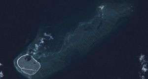
Satellite image of the islands
See also
References
- ↑ "Disputes - International". CIA World Factbook. Retrieved 8 November 2011.
| |||||||||||||||||||
| |||||||||||||||||||
| |||||||||||||||||||