Ghadames
- This article is about the town; for the former Libyan district see Ghadames District.
| Ghadames غدامس ʕademis(Berber) | |
|---|---|
| Town | |
|
Ghadames Mosque at night | |
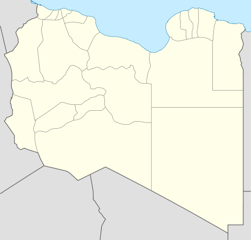 Ghadames Location in Libya | |
| Coordinates: 30°8′N 9°30′E / 30.133°N 9.500°ECoordinates: 30°8′N 9°30′E / 30.133°N 9.500°E | |
| Country |
|
| Region | Tripolitania |
| Municipality | Ghadames |
| Elevation[1] | 1,080 ft (330 m) |
| Population (2011)[2] | |
| • Total | approx. 10,000 |
| Time zone | EET (UTC+2) |

Ghadames or Ghadamis /ɡəˈdæmᵻs/ (Berber: ʕademis; Arabic: غدامس ɣadāmis, Libyan vernacular: ɣdāməs, Latin: Cidamus, Cydamus) is an oasis Berber town in the Nalut District of the Tripolitania region in northwestern Libya.
The indigenous language of Ghadames is Ghadamès, a Berber language.
Ghadamès, known as 'the pearl of the desert', stands in an oasis. It is one of the oldest pre-Saharan cities and an outstanding example of a traditional settlement. Its domestic architecture is characterized by a vertical division of functions: the ground floor used to store supplies; then another floor for the family, overhanging covered alleys that create what is almost an underground network of passageways; and, at the top, open-air terraces reserved for the women.[3]
Geography
Ghadames lies roughly 462 kilometres (287 mi) to the southwest of Tripoli, near the borders with Algeria and Tunisia. Ghadames borders Illizi Province, Algeria and Tataouine Governorate, Tunisia.
The oasis has a population of around 10,000, mainly Berbers. The old part of the town, which is surrounded by a city wall, has been declared a UNESCO World Heritage site. Each of the seven clans that used to live in this part of the town had its own district, of which each had a public place where festivals could be held.
Climate
Ghadames has a hot desert climate (Köppen climate classification BWh) with long, extremely hot summers as average high temperature is around 41 °C (105.8 °F) in July, the hottest month of the year as well as short, warm winters. The town is receives little precipitation throughout the year as average annual precipitation is only 33.1 mm (1.30 in).
| Climate data for Ghadames (1961–1990, extremes 1913–1993) | |||||||||||||
|---|---|---|---|---|---|---|---|---|---|---|---|---|---|
| Month | Jan | Feb | Mar | Apr | May | Jun | Jul | Aug | Sep | Oct | Nov | Dec | Year |
| Record high °C (°F) | 32.0 (89.6) |
35.0 (95) |
41.3 (106.3) |
48.0 (118.4) |
52.0 (125.6) |
55.2 (131.4) |
53.4 (128.1) |
52.4 (126.3) |
50.0 (122) |
48.0 (118.4) |
39.0 (102.2) |
30.4 (86.7) |
55.2 (131.4) |
| Average high °C (°F) | 17.6 (63.7) |
20.7 (69.3) |
24.4 (75.9) |
29.7 (85.5) |
34.6 (94.3) |
39.8 (103.6) |
40.3 (104.5) |
39.8 (103.6) |
36.4 (97.5) |
30.0 (86) |
23.8 (74.8) |
18.2 (64.8) |
29.6 (85.3) |
| Average low °C (°F) | 3.6 (38.5) |
5.7 (42.3) |
9.0 (48.2) |
13.8 (56.8) |
17.8 (64) |
22.3 (72.1) |
22.4 (72.3) |
22.5 (72.5) |
20.1 (68.2) |
15.0 (59) |
9.0 (48.2) |
4.4 (39.9) |
13.8 (56.8) |
| Record low °C (°F) | −6.9 (19.6) |
−8.0 (17.6) |
−2.6 (27.3) |
0.0 (32) |
6.0 (42.8) |
7.8 (46) |
10.8 (51.4) |
13.0 (55.4) |
10.0 (50) |
1.4 (34.5) |
−4.0 (24.8) |
−6.0 (21.2) |
−6.9 (19.6) |
| Average precipitation mm (inches) | 5.0 (0.197) |
4.6 (0.181) |
6.8 (0.268) |
3.6 (0.142) |
2.3 (0.091) |
0.1 (0.004) |
0.0 (0) |
0.3 (0.012) |
0.8 (0.031) |
4.0 (0.157) |
2.1 (0.083) |
3.4 (0.134) |
33 (1.3) |
| Average precipitation days (≥ 0.1 mm) | 1.1 | 1.2 | 1.5 | 0.9 | 0.4 | 0.2 | 0.1 | 0.1 | 0.2 | 1.0 | 0.8 | 1.2 | 8.7 |
| Average relative humidity (%) | 52 | 41 | 36 | 28 | 26 | 22 | 22 | 23 | 29 | 35 | 47 | 53 | 34 |
| Mean monthly sunshine hours | 248.0 | 240.1 | 257.3 | 273.0 | 313.1 | 309.0 | 372.0 | 353.4 | 273.0 | 263.5 | 246.0 | 232.5 | 3,380.9 |
| Mean daily sunshine hours | 8.0 | 8.5 | 8.3 | 9.1 | 10.1 | 10.3 | 12.0 | 11.4 | 9.1 | 8.5 | 8.2 | 7.5 | 9.3 |
| Source #1: WMO [4] | |||||||||||||
| Source #2: Deutscher Wetterdienst (extremes and humidity),[5] Arab Meteorology Book (sun only)[6] | |||||||||||||
History
Ancient eras
It has been suggested, based on archaeological evidence, that this area has been settled since the 4th millennium B.C., and is one of the oldest pre-Saharan settlements. Its situation near a water source in the middle of a desert would have made it an important spot for anyone seeking to settle in the area.
The first written records about Ghadames date from the Roman period when the settlement was known as Cydamus, from which modern Ghadames derives its name. In the 1st century BC, the Roman proconsul Lucius Cornelius Balbus invaded Cydamus during the reign of emperor Augustus.[7] A permanent Roman garrison was established during the reign of Septimius Severus, and the emperor may have visited the settlement around AD 202.[8] However, the Romans withdrew from the area a few decades later during the Crisis of the Third Century.

During the 6th century, a Bishop lived in the oasis, after the population had been converted to Christianity by Byzantine missionaries.
During the 7th century, Ghadames was ruled by the Muslim Arabs. The population quickly converted to Islam and Ghadames played an important role as base for the Trans-Saharan trade until the 19th century.
Etymology
The etymology of the name Ghadames is very closely linked with its history. It is believed that the name Ghadames is originally connected to the name of the ancient Berber tribe of Tidamensi, a tribe from Fezzan. It is also believed that the name Tidamensi was corrupted by the invading Romans to form the name Cydamus, which in turn gave way to the name Ghadames.[7]
1900s–present
In the 1970s, the government built new houses outside of the old part of the town. However, many inhabitants return to the old part of the town during the summer, as its architecture provides better protection against the heat.
During the Libyan Civil War, National Transitional Council forces entered the town on 30 August 2011,[9] which had been under siege by NTC forces since the beginning of the conflict. As of 2015, the city is under control by independent Tuareg troops. [10]
Old Town of Ghadames
| Old Town of Ghadamès | |
|---|---|
| Name as inscribed on the World Heritage List | |
 | |
| Type | Cultural |
| Criteria | v |
| Reference | 362 |
| UNESCO region | Arab States |
| Inscription history | |
| Inscription | 1986 (10th Session) |
The old town, inscribed in 1986 as a UNESCO World Heritage site, was de-populated of its inhabitants throughout the 1990s, leaving the old buildings at risk of collapse due to a lack of maintenance.[11]
Gallery
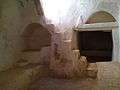 Ghadames Old Town Inside of small dwelling
 Libya Ghadames Old Town Rooftop View
 Libya Ghadames Old Town Spring Water Pool
 Libya Ghadames Old Town Wall Entrance
 Libya Ghadames Old Town Fruit Trees

See also
Notes
- ↑ Wolfram Alpha
- ↑ Der Spiegel, 2011 Aug 23
- ↑ Centre, UNESCO World Heritage. "Old Town of Ghadamès - UNESCO World Heritage Centre". whc.unesco.org. Retrieved 2016-07-20.
- ↑ "Climatological Information". World Meteorological Organization. Retrieved December 19, 2012.
- ↑ "Klimatafel von Ghadames / Libyen" (PDF). Baseline climate means (1961-1990) from stations all over the world (in German). Deutscher Wetterdienst. Retrieved 27 March 2016.
- ↑ "Appendix I: Meteorological Data" (PDF). Springer. Retrieved 27 March 2016.
- 1 2 "Ghadames (Ghudamis), Cydamus: the Pearl of The Libyan Sahara". Temehu.
- ↑ Birley, Anthony R. Septimius Severus: The African Emperor. London: Routledge. (2000) [1971]. pg 147.
- ↑ "Libyan fighters set to seize border town". PressTV. August 30, 2011.
- ↑ Libya: what about the south? The Guardian, 24 August 2011
- ↑ The World Heritage Newsletter, No.9, December 1995.
Further reading
- Edmond Bernet (1912). "Ghadames". En Tripolitaine: Voyage a Ghadames (in French). Paris: Fontemoing.
External links
| Wikimedia Commons has media related to Ghadames. |
- Falling Rain Genomics, Inc.: "Ghadamis, Libya"
- Azzouz, Intisar (1980) "Ghadames, Libya" In Safran, Linda (ed) (1980) Places of Public Gathering in Islam: proceedings of seminar five in the series Architectural transformations in the Islamic world, held in Amman, Jordan, May 4–7 Aga Khan Award for Architecture, Philadelphia, OCLC 7208199; photographs of Ghadames.
| Capital | ||
|---|---|---|
| Towns and villages | ||