Georgia State Route 256
| ||||
|---|---|---|---|---|
 | ||||
| Route information | ||||
| Maintained by GDOT | ||||
| Length: | 21.0 mi[1] (33.8 km) | |||
| Existed: | 1949[2][3] – present | |||
| Major junctions | ||||
| South end: |
| |||
| North end: |
| |||
| Location | ||||
| Counties: | Colquitt, Worth | |||
| Highway system | ||||
| ||||

State Route 256 (SR 256) is a south-north state highway located in the southern part of the U.S. state of Georgia. Its route is within Colquitt and Worth counties.
Route description
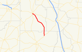
SR 256 begins at an intersection with US 319/SR 35 in Norman Park. It starts heading northwest and immediately curves to the north. Farther to the north, it crosses Warrior Creek. During its curve to the northwest, the route intersects Scooterville Tifton Road, which leads to Tifton. A short while later, SR 256 passes New Prospect Cemetery. It then meets Sumner Road South, which leads to Moultrie and Sumner. Just after this, it intersects Pine Forest Road, which leads to Tempy and Pine Forest cemeteries. It slides across the southwest corner of Poulan. Finally, it enters Sylvester on East Martin Luther King, Jr. Drive. It heads west, and meets its northern terminus, an intersection with SR 33 in Sylvester. Here, the East Martin Luther King, Jr. Drive designation continues to the west.[1]
No section of SR 256 is part of the National Highway System, a system of routes determined to be the most important for the nation's economy, mobility and defense.[4]
History
SR 256 was established in 1949 on the same alignment as it runs today.[2][3] In 1952, the section from Poulan to Sylvester was paved,[5][6] and, in 1953, the rest of the highway was paved.[6][7]
Major intersections
| County | Location | mi[1] | km | Destinations | Notes |
|---|---|---|---|---|---|
| Colquitt | Norman Park | 0.0 | 0.0 | Southern terminus | |
| Worth | Sylvester | 21.0 | 33.8 | Northern terminus | |
| 1.000 mi = 1.609 km; 1.000 km = 0.621 mi | |||||
See also
-
.svg.png) Georgia (U.S. state) portal
Georgia (U.S. state) portal -
 U.S. Roads portal
References
- 1 2 3 Google (February 22, 2013). "Route of SR 256" (Map). Google Maps. Google. Retrieved February 22, 2013.
- 1 2 Georgia State Highway System (PDF) (Map). Cartography by GSHD. Georgia State Highway Department. February 28, 1948. Retrieved February 22, 2013.
- 1 2 Georgia State Highway System (PDF) (Map). Cartography by GSHD. Georgia State Highway Department. April 1, 1949. Retrieved February 22, 2013.
- ↑ "National Highway System: Georgia" (PDF). United States Department of Transportation. May 8, 2009. Retrieved February 22, 2013.
- ↑ Georgia State Highway System (PDF) (Map). Cartography by GSHD. Georgia State Highway Department. August 1, 1950. Retrieved February 22, 2013.
- 1 2 Georgia State Highway System (PDF) (Map). Cartography by GSHD. Georgia State Highway Department. January 1, 1952. Retrieved February 22, 2013.
- ↑ Georgia State Highway System (PDF) (Map). Cartography by GSHD. Georgia State Highway Department. September 1, 1953. Retrieved February 22, 2013.