Georgia State Route 194
| ||||
|---|---|---|---|---|
| Durand Highway | ||||
 | ||||
| Route information | ||||
| Maintained by GDOT | ||||
| Length: | 5.33 mi[1] (8.58 km) | |||
| Major junctions | ||||
| West end: |
| |||
| East end: |
| |||
| Location | ||||
| Counties: | Meriwether | |||
| Highway system | ||||
| ||||

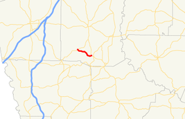
State Route 194 (SR 194) is a short 5.33-mile (8.58 km) state highway in the west-central part of the U.S. state of Georgia. It runs west-to-east entirely within Meriwether County.
Route description
The route begins at an intersection with SR 18 in the community of Durand. It curves to the southeast until it meets its eastern terminus, an intersection with US 27 Alternate/SR 41 west of Warm Springs.[2][3]
Major intersections
The entire route is in Meriwether County.
| Location | mi[1][3] | km | Destinations | Notes | |
|---|---|---|---|---|---|
| Durand | 0.00 | 0.00 | Western terminus | ||
| | 5.33 | 8.58 | Eastern terminus | ||
| 1.000 mi = 1.609 km; 1.000 km = 0.621 mi | |||||
See also
-
.svg.png) Georgia (U.S. state) portal
Georgia (U.S. state) portal -
 U.S. Roads portal
References
- 1 2 Office of Information Services (December 31, 2002). "State Highway System Mileage in Each County Classified by State Route Number and Federal-Aid System" (PDF). Georgia Department of Transportation. Archived from the original (PDF) on September 26, 2007. Retrieved January 7, 2013.
- ↑ General Highway Map - Meriwether County, Georgia (PDF) (Map). Georgia Department of Transportation. 2008. Retrieved January 7, 2013.
- 1 2 Google (June 4, 2013). "Route of SR 194" (Map). Google Maps. Google. Retrieved June 4, 2013.
External links
This article is issued from Wikipedia - version of the 9/14/2016. The text is available under the Creative Commons Attribution/Share Alike but additional terms may apply for the media files.