Georgia State Route 177
| ||||
|---|---|---|---|---|
 | ||||
| Route information | ||||
| Maintained by GDOT | ||||
| Length: | 24.4 mi[1][2] (39.3 km) | |||
| Southern section | ||||
| Length: | 17.7 mi[1] (28.5 km) | |||
| South end: |
| |||
| North end: | Dead end in Stephen C. Foster State Park | |||
| Northern section | ||||
| Length: | 6.7 mi[2] (10.8 km) | |||
| South end: |
| |||
| North end: |
| |||
| Location | ||||
| Counties: | Clinch, Ware, Charlton, Brantley | |||
| Highway system | ||||
| ||||

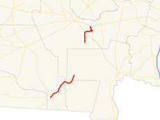
State Route 177 (SR 177) is a 24.4-mile (39.3 km) state highway in the southeastern part of the U.S. state of Georgia. It exists in two distinct sections, split by the Okefenokee National Wildlife Refuge, Okefenokee Swamp, and Okefenokee Wilderness, that runs south-to-north through portions of Clinch, Ware, Charlton, and Brantley counties.
Route description
Southern segment
SR 177 begins at an intersection with US 441/SR 89/SR 94 just southeast of Fargo, in Clinch County. It heads northeast, through portions of Ware and Charlton counties. SR 177 enters the Okefenokee Swamp and then the Okefenokee National Wildlife Refuge. Farther to the northeast it enters Stephen C. Foster State Park and ends at a dead end in the northern end of the park.[1]
Northern segment
The route resumes at an intersection with US 1/US 23/SR 4 west of Laura S. Walker State Park, which is located southeast of Waycross, in Ware County. It runs along the southern edge of the park, and very briefly enters Brantley County. SR 177 re-enters Ware County, and enters the park. The highway heads to the north-northwest of US 82/SR 520, north of the park.[2]
National Highway System
SR 177 is not part of the National Highway System, a system of roadways important to the nation's economy, defense, and mobility.[3]
Major intersections
- Southern segment
| County | Location | mi[1] | km | Destinations | Notes | |||
|---|---|---|---|---|---|---|---|---|
| Clinch | | 0.0 | 0.0 | Southern terminus | ||||
| Ware |
No major junctions | |||||||
| Charlton | Stephen C. Foster State Park | 17.7 | 28.5 | Dead end | Northern terminus | |||
| 1.000 mi = 1.609 km; 1.000 km = 0.621 mi | ||||||||
- Northern segment
| County | Location | mi[2] | km | Destinations | Notes | |||
|---|---|---|---|---|---|---|---|---|
| Ware | | 0.0 | 0.0 | Southern terminus | ||||
| Brantley |
No major junctions | |||||||
| Ware | | 6.7 | 10.8 | Northern terminus | ||||
| 1.000 mi = 1.609 km; 1.000 km = 0.621 mi | ||||||||
See also
-
.svg.png) Georgia (U.S. state) portal
Georgia (U.S. state) portal -
 U.S. Roads portal
References
- 1 2 3 4 Google (June 22, 2013). "Route of SR 177's Southern Section" (Map). Google Maps. Google. Retrieved June 22, 2013.
- 1 2 3 4 Google (June 22, 2013). "Route of SR 177's Northern Section" (Map). Google Maps. Google. Retrieved June 22, 2013.
- ↑ "National Highway System: Georgia" (PDF). United States Department of Transportation. October 1, 2012. Retrieved August 7, 2013.
External links
-
 Media related to Georgia State Route 177 at Wikimedia Commons
 - Georgia Roads (Routes 161 - 180)
- Georgia State Route 177 on State-Ends.com