Georgetown, California
| Georgetown | |
|---|---|
| census-designated place | |
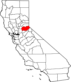
 Location in El Dorado County and the state of California | |
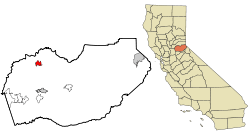
 Georgetown Location in the United States | |
| Coordinates: 38°54′25″N 120°50′19″W / 38.90694°N 120.83861°WCoordinates: 38°54′25″N 120°50′19″W / 38.90694°N 120.83861°W | |
| Country |
|
| State |
|
| County | El Dorado |
| Area[1] | |
| • Total | 15.132 sq mi (39.193 km2) |
| • Land | 15.128 sq mi (39.182 km2) |
| • Water | 0.004 sq mi (0.011 km2) 0.03% |
| Elevation | 2,654 ft (809 m) |
| Population (2010) | |
| • Total | 300 |
| • Density | 20/sq mi (7.7/km2) |
| Time zone | Pacific (PST) (UTC-8) |
| • Summer (DST) | PDT (UTC-7) |
| ZIP code | 95634 |
| Area code(s) | 530 |
| FIPS code | 06-29350 |
| GNIS feature ID | 1658606 |
| Reference no. | 484 |
Georgetown (formerly, Growlersburg)[2] is a census-designated place (CDP) in El Dorado County, California. It is the northeastern-most town in the California Mother Lode.[3] The population was 2,367 at the 2010 census, up from 962 in 2000. The town is registered as California Historical Landmark #484.[4]
History
Founded August 7, 1849, by George Phipps and party, Georgetown was nicknamed "Growlersburg" due to the heavy, gold-laden quartz rocks that "growled" in the miners' pants pockets as they walked around town. Georgetown is named for George Washington.[5] The first post office was established in 1851.[2] After a disastrous fire in 1852 the old town was moved from the canyon in lower Main Street to its present site, and, unique in early-day planning, Main Street was laid out 100 feet (30 m) wide, with side streets 60 feet (18 m). After this new reconstruction, the residents of the city proclaimed their town as the "Pride of the Mountains". The hub of an immensely rich gold mining area, Georgetown had a population of about three thousand from 1854 to 1856. As a gold rush camp, the community outlasted many other towns, because the gold found nearby was solid primary deposits, as opposed to placer deposits. Gold production continued until after the turn of the 20th century.[3]
Geography
According to the United States Census Bureau, the CDP has a total area of 15.1 square miles (39 km2), of which over 99% is land.
For the 2000 census, the CDP's area was smaller. It had a total area of 4.1 square miles (11 km2), of which 4.1 square miles (11 km2) was land and 0.24% was water.
Climate
According to the Köppen climate classification system, Georgetown has a warm-summer Mediterranean climate, abbreviated "Csa" on climate maps.[6]
Demographics
2010
The 2010 United States Census[7] reported that Georgetown had a population of 2,367. The population density was 156.4 people per square mile (60.4/km²). The racial makeup of Georgetown was 2,128 (89.9%) White, 47 (2.0%) African American, 59 (2.5%) Native American, 18 (0.8%) Asian, 2 (0.1%) Pacific Islander, 45 (1.9%) from other races, and 68 (2.9%) from two or more races. Hispanic or Latino of any race were 177 persons (7.5%).
The Census reported that 2,239 people (94.6% of the population) lived in households, 14 (0.6%) lived in non-institutionalized group quarters, and 114 (4.8%) were institutionalized.
There were 913 households, out of which 242 (26.5%) had children under the age of 18 living in them, 521 (57.1%) were opposite-sex married couples living together, 66 (7.2%) had a female householder with no husband present, 64 (7.0%) had a male householder with no wife present. There were 46 (5.0%) unmarried opposite-sex partnerships, and 7 (0.8%) same-sex married couples or partnerships. 218 households (23.9%) were made up of individuals and 97 (10.6%) had someone living alone who was 65 years of age or older. The average household size was 2.45. There were 651 families (71.3% of all households); the average family size was 2.82.
The population was spread out with 441 people (18.6%) under the age of 18, 181 people (7.6%) aged 18 to 24, 513 people (21.7%) aged 25 to 44, 809 people (34.2%) aged 45 to 64, and 423 people (17.9%) who were 65 years of age or older. The median age was 46.4 years. For every 100 females there were 111.0 males. For every 100 females age 18 and over, there were 114.7 males.
There were 1,069 housing units at an average density of 70.6 per square mile (27.3/km²), of which 709 (77.7%) were owner-occupied, and 204 (22.3%) were occupied by renters. The homeowner vacancy rate was 3.5%; the rental vacancy rate was 8.1%. 1,689 people (71.4% of the population) lived in owner-occupied housing units and 550 people (23.2%) lived in rental housing units.
2000
As of the census[8] of 2000, there were 962 people, 389 households, and 266 families residing in the CDP. The population density was 233.4 people per square mile (90.2/km²). There were 423 housing units at an average density of 102.6 per square mile (39.6/km²). The racial makeup of the CDP was 95.11% White, 0.10% African American, 1.35% Native American, 1.35% Asian, 0.42% from other races, and 1.66% from two or more races. 3.74% of the population were Hispanic or Latino of any race.
There were 389 households out of which 28.3% had children under the age of 18 living with them, 54.5% were married couples living together, 8.5% had a female householder with no husband present, and 31.4% were non-families. 25.7% of all households were made up of individuals and 11.1% had someone living alone who was 65 years of age or older. The average household size was 2.46 and the average family size was 2.92.
In the CDP the population was spread out with 23.6% under the age of 18, 8.2% from 18 to 24, 22.6% from 25 to 44, 28.9% from 45 to 64, and 16.7% who were 65 years of age or older. The median age was 42 years. For every 100 females there were 100.8 males. For every 100 females age 18 and over, there were 100.3 males.
The median income for a household in the CDP was $41,111, and the median income for a family was $42,609. Males had a median income of $39,934 versus $40,208 for females. The per capita income for the CDP was $17,582. About 13.4% of families and 15.8% of the population were below the poverty threshold, including 17.5% of those under age 18 and 5.2% of those age 65 or over.
Politics
In the state legislature, Georgetown is in the 1st Senate District, represented by Republican Ted Gaines,[9] and the 5th Assembly District, represented by Republican Frank Bigelow.[10]
Federally, Georgetown is in California's 4th congressional district, represented by Republican Tom McClintock.[11]
Education
The Black Oak Mine Unified School District, headquartered in Georgetown,[12] serves Georgetown.[13]
See also
References
- ↑ "2010 Census U.S. Gazetteer Files – Places – California". United States Census Bureau.
- 1 2 Durham, David L. (1998). California's Geographic Names: A Gazetteer of Historic and Modern Names of the State. Clovis, Calif.: Word Dancer Press. p. 490. ISBN 1-884995-14-4.
- 1 2 Varney, Philip (2001). Ghost Towns of Northern California. St. Paul, MN: Voyageur Press. p. 22. ISBN 978-0-89658-442-6.
- ↑ "Georgetown". Office of Historic Preservation, California State Parks. Retrieved 2012-10-07.
- ↑ Gannett, Henry (1905). The Origin of Certain Place Names in the United States. Govt. Print. Off. p. 136.
- ↑ Climate Summary for Georgetown, California
- ↑ "2010 Census Interactive Population Search: CA - Georgetown CDP". U.S. Census Bureau. Retrieved July 12, 2014.
- ↑ "American FactFinder". United States Census Bureau. Retrieved 2008-01-31.
- ↑ "Senators". State of California. Retrieved April 5, 2013.
- ↑ "Members Assembly". State of California. Retrieved April 5, 2013.
- ↑ "California's 4th Congressional District - Representatives & District Map". Civic Impulse, LLC. Retrieved March 2, 2013.
- ↑ "Welcome to the Black Oak Mine Unified School District." Black Oak Mine Unified School District. Retrieved on October 27, 2010.
- ↑ Home page. Black Oak Mine Unified School District. July 20, 2002. Retrieved on October 27, 2010.