George Town, Chennai
| George Town Black Town Georgetown | |
|---|---|
| neighbourhood | |
 George Town 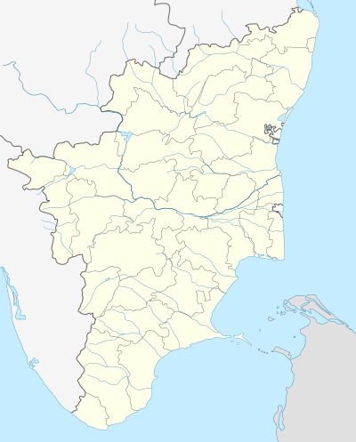 George Town  George Town | |
| Coordinates: 13°05′38″N 80°17′02″E / 13.0939°N 80.2839°ECoordinates: 13°05′38″N 80°17′02″E / 13.0939°N 80.2839°E | |
| Country | India |
| State | Tamil Nadu |
| District | Chennai District |
| Metro | Chennai |
| Ward | Muthialpet |
| Founded by | British East India Company |
| Named for | King George V |
| Government | |
| • Body | Chennai Corporation |
| Area | |
| • Total | 4 km2 (2 sq mi) |
| Languages | |
| • Official | Tamil |
| Time zone | IST (UTC+5:30) |
| PIN | 600001 |
| Lok Sabha constituency | Chennai Central |
| Planning agency | CMDA |
| Civic agency | Chennai Corporation |
| Website |
www |
George Town is a historical neighbourhood of Fort Saint George in Chennai (formerly Madras), India. Also known as Black Town during the colonial period, the settlement was formed after the English constructed the fort and was the first settlement of the city of Madras, begun soon after the completion of the fort. The name of this area 'Black Town' was renamed as George Town in 1911 in honour of King George V when he was crowned as the Emperor of India.[1] The name is still in use officially unlike other names that have been changed in the recent times, thus being reminiscent of the colonial past. This is where the modern city of Madras began its expansion in the 1640s.
History
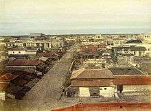
In 1639, when Francis Day was looking for somewhere to build a fortified warehouse for the English East India Company, he soon acquired the land where, in 1640, he built the compound named Fort St George. Soon after it was built, a township began to grow up around it for the natives catering to the needs of the Europeans inside, and this became known as the Black Town. As the city grew, this area became the base for development and construction activities, meeting the needs of people for their livelihood and rulers' administrative comforts. With the construction of one of India's major ports in the area, Madras became an important naval base for the British.

By the early 18th century, with a growing population and commercial activities, there was congestion in Black Town, resulting in dispersion of some of the population to neighbouring areas. In 1733, the weaving community started to settle down in Chintadripet and Collepetta near Tiruvottiyur, since abundant open space was available for weaving. The community of washermen in the Mint area then moved towards the west, forming the present Washermanpet. Potters from this area moved outside the Fort on the north side and formed a new colony named Kosapet. With the construction of a bridge in 1710 to connect Egmore, people started moving towards the present Moore Market area.[2]
When the French occupied Madras in 1746 and returned it to the English in 1749 in exchange for Quebec by the Treaty of Aix-la-Chapelle, the English flattened a part of Black Town in order to have a clear field for fire in the event of a future attack. In 1773, the English erected 13 pillars along the flattened area of the Black Town and banned construction in any form between the pillars and the fort which would otherwise block the view of possible invaders. Soon a new township, known as the new Black Town, came up beyond these pillars and the old Black Town gave way to the Madras High Court. A thoroughfare was formed along the stretch between the pillars and the high court which later became the China Bazaar Road. The only surviving one of the 13 pillars is being maintained in the compound of the Parry's building.[3]
In 1772, the first organised water supply of Madras began with the Seven Wells Scheme.[4] On one occasion, Mysore ruler Hyder Ali's troops even tried to poison the water source one night.[3]
In the following centuries, High Court buildings and first light house tower with architectural beauty came up in an area where an old Hindu temple of Sri Chennakesava perumal and Chennamalleswara swamy existed. This temple was demolished and later shifted to the present place near Mint Street on Nethaji Subhash Chandra Bose Road and is popular amongst Hindus as Pattanam Koil.
Several Tamil refugees from Burma, who fled Myanmar during the early sixties, arrived in George Town. In 1969, the Burma Bazaar, a market selling imported foreign goods in shops on pavements, was established by these Burmese refugees-turned-entrepreneurs.[5]
Religions and holy shrines
George Town has a dense congregation of shrines of different faiths within its boundaries. The first Hindu temples of British Madras were built in the neighbourhood between 1640 and 1680. Many of the temples were built since then by the leading merchants of the city, mostly dubashes (middlemen) of British merchants and business establishments. Several of the streets in the neighbourhood are named after these dubashes.[6]
The city's first Jain temples were built in the central part of the western half of the neighbourhood occupied by settlers from Rajasthan and Saurashtra, now known as Sowcarpet. Today, festivals such as Holi, Diwali, and Ganesh Chathurthi are celebrated in the North Indian style.[6]
The first mosque in the neighbourhood was built in the 1670s on Moor Street. The mosque, however, does not exist today. The oldest surviving mosque is the huge Masjid Mamoor in Angappa Naicken Street, which was built in the eighteenth century.[6]
The first synagogue was built in Coral Merchant Street, which had a large presence of Portuguese Jews in the seventeenth and eighteenth centuries. Neither the synagogue nor the Jewish population remains today. The oldest church is the Armenian Church on Armenian Street. The Cathedral of St Mary of the Angels located next to the church has its presence since 1642. However, the first Catholic place of worship in the neighbourhood was built before the cathedral. Protestant churches, however, were built only in the nineteenth century, with the first English Protestant Church built in 1810 on Davidson Street.[6]
The Muthialpet area, the western part of George Town extending northwards from the Madras High Court, is one of the 163 notified areas (megalithic sites) in the state of Tamil Nadu.[7]
Geography

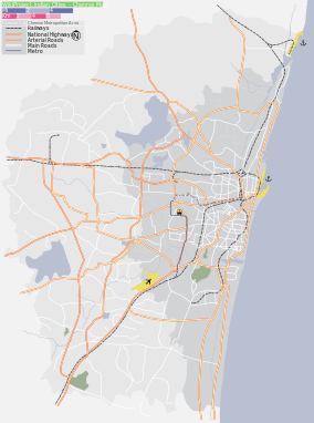
George Town is located along the shores of the Bay of Bengal, marking the beginning of Northern Chennai. The neighbourhood covers an area of about 850 acres (approximately 3.5 square kilometres)[6] and appears as a trapezium-shaped area from the sky bordered on its four sides by four stretches of roads. The western side is bordered by the Wall Tax Road and the Buckingham Canal. The south side is bordered by the North Fort Road on the eastern side and the General Hospital Road on the western side which marks the beginning of the arterial Poonamallee High Road. The northern side is bordered by Basin Bridge Road and Old Jail Road. The eastern side is bordered by the Rajaji Salai and the Chennai Port. All the four sides are additionally bordered by railway lines of the Chennai Beach—Chengalpattu and Chennai Central—Chennai Beach sections. The neighbourhood is criss-crossed by parallelly laid streets running along north–south and east–west directions. Regions within the neighbourhood include Parry's Corner, Esplanade, Edapalaiyam, Sowcarpet, Elephant Gate, Mannady, Seethakadhi Nagar, Thiruvalluvar Nagar, Seven Wells, Trevelyan Basin, Peddanaickenpet, Kondithope, Asirvadhapuram, Muthiyala Pettai, Pookkadai (Flower Bazaar), Perumal Koil Garden, Badhri Garden, Rattan Bazaar, Krishnappa Naicken Agraharam, Chengankadai, Kachaleswarar Garden, and Broadway.
Being on the coast, the region historically had many sand ridges. During the 16th century, the level of the sea rose and inundated lands within the settlements. When the sea withdrew, it left behind several lagoons and ridges. The lagoons took some time to become filled in and the sandy ridges became places of safety where new temples and settlements were established. Two of the ridges were prominent—one between Broadway and the beach with a height of about 12 feet running roughly along Thambuchetty Street and the other one along Mint Street. From First Line Beach, the land slowly rose to the ridge and then fell to a valley along the present-day Broadway, where a drainage channel ran. Again it rose to the second ridge in Mint Street and descended gradually to a valley along the present-day Buckingham Canal. The Mint Street ridge continued along Tiruvottiyur High Road.[2]
Some portraits displayed in the Fort Museum housed in the Fort shows tides of the sea almost very close to the Fort. River Coovam flowing little south of the Fort separates the neighbourhood from the rest of the city. The present day Prakasam Road (formerly known as 'Broadway') was originally a part of the river's watercourse. However, after the river completely dried up, this looked very broad through bushes and became to be known as Broadway. It is also said that there existed several tanks and ponds in the locality that gradually disappeared due to human encroachments. This can be noted in the names of some of the localities within the neighbourhood such as Sanikulam and Krishnankulam (Kulam in Tamil means tank or pond).
George Town is primarily sandy as most areas along the river banks and coasts in the city.[8]
Location in context
 |
Washermanpet | Royapuram | Chennai Port | |
| Basin Bridge | |
Chennai Port | ||
| ||||
| | ||||
| Esplanade / Park Town | High Court / Fort St George | Parrys Corner |
Demographics
Residents of George Town in earlier days were mainly Telugus with sizable population of Tamils. In the core area, streets are named after Telugu people such as Govindappa Naick, Angappa Naick, Adiyappa Naick, Narayana Mudali, Kasi Chetty, Rasappa Chetty, Varada Muthiappan, Thatha Muthiappan, Kondi Chetty, Linghi Chetty, Thambu Chetty, and so forth. A major part of trade and business was in the hands of Telugus. Apart from locals, people from other parts of the country as well as foreign nationals who had trade and business links with the British 'East India Company' were living in this area. Many of the streets bear the name of the business that people in the locality were engaged in. Men who were doing business in corals lived together in Coral Merchants Street (பவழக்கார தெரு) and people from Armenia (a former state of Russia) doing business with the English were living in Armenian Street (அரண்மனைக்காரர் தெரு). A church called Armenian Church was also constructed in the same area for them. As the town was developing manifold, people from all over India settled in hundreds of thousands doing business in all fields, chiefly from Rajasthan, Gujarat, Maharashtra and Uttar Pradesh. The area occupied by the North Indians, chiefly Marwaris from Rajasthan and Gujarat, in the twentieth century came to be known as Sowcarpet (literally 'area of the rich', derived from the word 'sahukar' meaning money lender in Hindi).[9]
Roads and streets

Major roads of the neighbourhood include Netaji Subash Chandra Bose Road (popularly known as China Bazaar Road), Rajaji Salai (formerly First Line Beach road) and Wall Tax Road. The streets are generally small and narrow with several lanes branching out of them. The longest street is Mint Street, which starts near Central Railway Station making way across the neighbourhood for about 4 km towards north and ends near Vallalar Nagar. The street derived its name from a mint of the East India Company that existed at the end of this street during the British era.[9] Now the building houses Central Printing Press of Government of Tamil Nadu. This is considered one of few longest streets in the world. Several government offices, both state and central governments, including Andaman & Nicobar Island government's administrative offices of Shipping and Tourism Departments, are located on Rajaji Salai. The very attractive Burma Bazaar, noted for selling electronic goods and other items at cheaper rates, once wholly run by Burmese refugees, is also located on this road.

Streets and specialities
| Street Name | Speciality |
|---|---|
| Mannadi Street | Textiles, imported goods, eateries |
| Moore Street | Cereals and pulses, hotels, and lodges |
| Angappa Naicken Street | Masjid, textile, eateries |
| Burma Bazaar | Grey market for electronic goods, cameras, luggage, perfumes and accessories |
| Linghi Chetty Street | Steel hardware, electric motors and pump sets |
| Thambu Chetty Street | Hardware, ceramic tiles and sanitary ware |
| Sembudoss Street | Steel sheets and rods, pipes |
| Broadway | Cycles and optical goods, Deva Opticals |
| Anderson Street | Stationery |
| Godown Street | Textiles |
| Govindappa Naicken Street | Electrical goods, dry fruits |
| Nainiappa Naicken Street | Chemicals and surgical instruments, pharma, plywood, glass, laminates, photo frames |
| Coral Merchant Street | Transport and shipping offices |
| Evening Bazaar | Household appliances and domestic utensils |
| Kasi Chetty Street | Stationeries |
| Bunder Street | Books, stationeries and crackers |
| Badrian Street | Crackers |
| Elephant Gate | Textiles |
| Rajaji Salai | Banks, trading offices, shipping corporations |
Buildings and landmarks
This area has many heritage and modern buildings on Rajaji salai and NSC Bose Road. Heritage buildings include High Court Buildings, Old lighthouse tower and Law college building at Parry's Corner and GPO building and Reserve Bank of India Building on Rajaji Salai. Other modern buildings are Parry's Dare House, State Bank of Mysore Building, New Collectorate Office Building (Singaravelar Maaligai), Kuralagam, and BSNL office buildings. Raja Annamalai Mandram is a big hall where indoor meetings, cultural activities and dramas are held. In addition, there are lot of buildings owned by business community and government.

Land use
The land use in George Town primarily comprises residential and mixed-residential zones. It is classified as a 'continuous building area', permitting structures of ground-plus-one floor, with a floor space index of 1.5. As of 2014, the business district has more than 14,000 buildings with around 25,000 property tax assessees.[10]
All buildings in George Town have been found in violation of development regulations, with several buildings found to have been constructed without obtaining building approval from the corporation.[10]
Economy
George Town is the birthplace of the economy of the city that began to flourish in the 17th century. Being the primary neighbourhood of the then burgeoning city of Madras, George Town houses several commercial establishments of national importance. It long housed the central business district of the city, until the 1960s, when it began to drift towards the south to reach the Gemini circle.
Banking

The neighbourhood and the surrounding areas were home to several Nattukottai Chettiars or Nagarathars, who offered banking services to the public in the city before the establishment of modern commercial banks. They both offered loans to and accepted money deposits from the public, besides offering liberal loans to the agricultural labourers. Several banking and financial offices were housed in heritage structures from the Colonial era, clustered chiefly around North Beach Road, many of which continue to exist to the present day.[11]
The first European-style banking system in India was started in George Town with the establishment of the 'Madras Bank' on 21 June 1683, almost a century before the establishment of the first commercial banks, such as the Bank of Hindustan and the General Bank of India, which were established in 1770 and 1786, respectively. However, the bank proved a failure.[12] Upon the recommendation of the British Finance Committee on the formation of a government bank, the Madras Bank, then known as the 'Government Bank', started functioning again from 1806. In 1843, the bank merged with the Carnatic Bank (1788), the British Bank of Madras (1795) and the Asiatic Bank (1804) and became the Bank of Madras, which was one of the three Presidency banks of India. In 1921, it merged with the other two Presidency banks, namely the Bank of Bengal and the Bank of Bombay, to form the Imperial Bank of India, which later became the State Bank of India in 1955.[13] The neighbourhood is also home to the south zonal office of the Reserve Bank of India, the country's central bank.[14]
Transportation
George Town remains the geometrical focal point of Chennai where all the radial roads and railroads of the city converge. The arterial roads, namely, North and South Beach Roads, Anna Salai, Poonamallee High Road, Grand Northern Trunk Road, and Ennore High Road radiate from the neighbourhood, and both the primary terminal railway stations of the city, namely, Chennai Central and Chennai Beach borders the western and eastern sides of the neighbourhood. In addition to the two terminal stations, many suburban railway stations are located circumferentially around the neighbourhood, namely, Chennai Central Suburban, Chennai Fort, Chennai Park and Park Town, all located in the south and southwest fringes, Basin Bridge Junction at the western fringe, and Royapuram railway station at the northern fringe. The neighbourhood has a bus terminus at Esplanade (Broadway Bus Stand) near Parry's Corner.
The intercity and interstate express bus terminus was originally functioned at the Broadway terminus near Madras High Court in an area covering about 1.5 acres.[15] With the increasing transportation need, the terminus was shifted to a new premises covering 36.5 acres at Koyambedu in 2002 constructed at a cost of ₹ 1,030 million.[16][17]
In January 2013, further to the public interest litigation petition filed in the court, the Corporation decided to improve the Broadway bus terminus at an estimated cost of ₹ 33.6 million.[18]
Education
Colleges and universities

George Town is home various government-run colleges and institutions. Dr. Ambedkar Law College, initially known as Madras Law College, was established in 1891. The medical college of the Government Stanley Medical College and Hospital was established in 1938 although the hospital was established by the turn of the 19th century. The Government Dental College and Hospital was established in 1953. Bharathi Women's College is located in the northern side of the neighbourhood.
Primary and secondary schools
It has many premier schools which includes St. Mary's Anglo-Indian Higher Secondary School and apart from that other schools like St. Columban's Anglo-Indian Higher Secondary School and others include The Muthialpet Higher Secondary School, St.Gabriel's Higher Secondary School,Ramiah Girls High School, MEASI Matriculation Higher Secondary School, Muthialpet Girls School, Bishop Corrie Higher Secondary School, and St. Francis Xavier and Dominic Savio School.
Developments
Although George Town is the origin of the modern city of Chennai and remained the chief commercial hub of the city till the early 20th century, the city's central business district gradually moved towards the south since the mid-20th century, presently lying at the Gemini Circle on Anna Salai. This resulted in the whole of the northern region of the city being qualified as neglected backward region. However, some of the community-specific areas of George Town, such as Sowcarpet where the prosperous Marwari community resides, still remains an important commercial hub of the city.[3]
Political awareness
Political awareness among citizens of George Town is very high. Almost all leaders of national and state political parties used to hold street meetings contacting people and propagating their aims and principles. Leaders such as C. N. Annadurai, K. Kamaraj, C. Rajagopalachary, E. V. K. Ramaswamy Naicker, M. P. Sivagnanam (Ma. Po. Si), Andhra leaders such as T. Prakasam and also Mahatma Gandhi, Annie Besant and many others did not miss this part of the city. With huge immigrant population settled here, not only local and state politics but also politics of all other states of the country and even foreign nations are well known here. All political parties make it a point to be in good books of the citizens. The DMK party, one of the chief political parties of Tamil Nadu, counts Coral Merchant Street as its birthplace in 1949.[19]
See also
References
- ↑ Muthiah, S. (1 January 2012). "Madras miscellany: A forgotten name-change". The Hindu. Chennai: The Hindu. Retrieved 28 Apr 2012.
- 1 2 "Structure of Chennai" (PDF). Chapter 1. CMDA. Retrieved 24 Feb 2013.
- 1 2 3 TNN (27 August 2010). "Chennai High: Where history beckons". The Times of India. Chennai: The Times Group. Retrieved 19 Jan 2013.
- ↑ "1751 A.D. to 1800 A.D.". History of Chennai. ChennaiBest.com. Retrieved 20 Jan 2013.
- ↑ Venkat, Vidya (21 July 2008). "Grey markets, but never in the red". The Hindu. Chennai: The Hindu. Retrieved 16 Mar 2014.
- 1 2 3 4 5 C. S. Lakshmi (Ed.) (2004). The Unhurried City: Writings on Chennai. Penguin Books India. pp. 30–31. Retrieved 30 Mar 2014.
- ↑ Madhavan, D. (20 December 2012). "National Institute of Siddha modifies expansion plan". The Hindu. Chennai: The Hindu. Retrieved 23 Dec 2012.
- ↑ Lakshmi, K. (28 August 2012). "Tardy monsoon: Chennai water table rises only marginally". The Hindu. Chennai: The Hindu. Retrieved 30 Mar 2014.
- 1 2 Todhunter, Colin (14 February 2013). "Hot mint in Chennai: welcome to India". Travelmag. Retrieved 16 Mar 2014.
- 1 2 Lopez, Aloysius Xavier (7 November 2014). "George Town buildings flout rules". The Hindu. Chennai. Retrieved 16 November 2014.
- ↑ Suresh, S. (3 November 2012). "The Banking Heritage of Madras". The Times of India. Chennai. Retrieved 28 December 2012.
- ↑ Mukund, Kanakalatha (3 April 2007). "Insight into the progress of banking". The Hindu. Chennai. Retrieved 28 December 2012.
- ↑ Kumar, Shiv (26 June 2005). "200 years and going strong". The Tribune. Retrieved 28 December 2012.
- ↑ "About Us". Reserve Bank of India. Retrieved 28 December 2012.
- ↑ "கலக்கப் போகுது பிராட்வே பஸ் நிலையம்". Dinamalar. Chennai: Dinamalar. 22 July 2012.
- ↑ "Jayalalithaa inaugurates new bus terminus in Chennai". The Hindu Business Line. Chennai: The Hindu. 19 November 2002. Retrieved 16 Oct 2011.
- ↑ "Chennai Mofussil Bus Terminal (CMBT)". CMDA. Retrieved 16 Oct 2011.
- ↑ "Broadway bus stand to get facelift". The Hindu. Chennai: The Hindu. 9 January 2013. Retrieved 9 Jan 2013.
- ↑ Ghosh, Bishwanath (5 May 2011). "In Search of 7, Coral Merchant Street". The Hindu. Chennai: The Hindu. Retrieved 30 Mar 2014.
External links
| Wikimedia Commons has media related to George Town, Chennai. |