Geology of Bangladesh
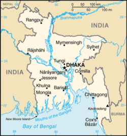
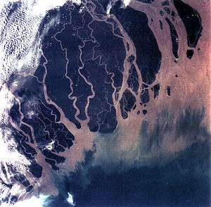
The Geology of Bangladesh is affected by the country's location, as Bangladesh is a riverine country. It is the eastern two-thirds of the Ganges and Brahmaputra river delta plain stretching to the north from the Bay of Bengal. There are two smaller areas of higher jungle composed of old alluvium called the Madhupur tract and the Barind Tract.[1]
The rivers are the most significant feature of Bangladesh geology as they constantly change course, sometimes rapidly, so that topological features of Bangladesh are ever changing.[2]
The downward twisting of the basement rocks under central and southern Bangladesh result from the pressure of sediments that have been accumulating since the Cretaceous period, mostly a large quantity of carbonate. In the Late Eocene epoch the conditions in the Bay of Bengal changed and these deposits ceased.[3]
References
- ↑ "Bangladesh". Encyclopædia Britannica. Retrieved 2007-08-18.
- ↑ "Bangladesh, page 2". Encyclopædia Britannica. Retrieved 2007-08-19.
- ↑ Akon, Eunuse (2012). "Basement". In Islam, Sirajul; Jamal, Ahmed A. Banglapedia: National Encyclopedia of Bangladesh (Second ed.). Asiatic Society of Bangladesh.
External links
- Bangladesh Agricultural Research Institute
- Country Profile: Bangladesh
- Geology of Bangladesh
- Guha, DK (2012). "Tectonic Framework". In Islam, Sirajul; Jamal, Ahmed A. Banglapedia: National Encyclopedia of Bangladesh (Second ed.). Asiatic Society of Bangladesh.
- Bakr, M Abu (2012). "Stratigraphy". In Islam, Sirajul; Jamal, Ahmed A. Banglapedia: National Encyclopedia of Bangladesh (Second ed.). Asiatic Society of Bangladesh.