Geography of Kolkata

Kolkata is located in the eastern part of India. It has spread linearly along the banks of the Hooghly River. The Kolkata Municipal Corporation has an area of 185 square kilometres. The city is near sea level, with the average elevation being 17 feet.[1] The whole area is in the Ganges Delta and is monotonously plain. The Bay of Bengal coastline is about 60 miles to the south. The Sundarbans National Park starts within 100 km south to the city. Most of the city was originally marshy wetlands, remnants of which can still be found especially towards the eastern parts of the city where the remaining wetlands have been converted to fish farming centres. Human habitation has led to the establishment of mature trees and shrubs. The original marshland has been changed to a primarily moist deciduous habitat which flourishes under the high rainfall and sunny humid climate.[2] As in most of the Indo-Gangetic plain, the soil type is predominantly alluvial.
Geology
As with most of the Indo-Gangetic Plain, the soil and water are predominantly alluvial in origin. Kolkata is located over the "Bengal basin", a pericratonic tertiary basin.[3] Bengal basin comprises three structural unit: shelf or platform in the west; central hinge or shelf/slope break; and deep basinal part in the east and southeast. Kolkata is located atop the western part of the hinge zone which is about 25 km (16 mi) wide at a depth of about 45,000 m (148,000 ft) below the surface.[3] The shelf and hinge zones have many faults, among them some are active. Total thickness of sediment below the Kolkata is nearly 7,500 m (24,600 ft) above the crystalline basement; of these the top 350–450 m (1,150–1,480 ft) is quaternary, followed by 4,500–5,500 m (14,760–18,040 ft) of tertiary sediments, 500–700 m (1,640–2,300 ft) trap wash of cretaceous trap and 600–800 m (1,970–2,620 ft) permian-carboniferous Gondwana rocks.[3] The quaternary sediments consist of clay, silt, and several grades of sand and gravel. These sediments are sandwiched between two clay beds: the lower one at a depth of 250–650 m (820–2,130 ft); the upper one 10–40 m (30–130 ft) in thickness.[4] According to the Bureau of Indian Standards, on a scale ranging from I to V in order of increasing susceptibility to earthquakes, the city lies inside seismic zone III.[5]
City geography

Spread roughly north–south along the east bank of the Hooghly River, Kolkata sits within the lower Ganges Delta of eastern India; the city's elevation is 1.5–9 m (5–30 ft).[6]
The Kolkata metropolitan area is spread over 1,886.67 km2 (728.45 sq mi)[7]:7 and comprises 3 municipal corporations (including Kolkata Municipal Corporation), 39 local municipalities and 24 panchayat samitis, as of 2011.[7]:7 The urban agglomeration encompassed 72 cities and 527 towns and villages, as of 2006.[8] Suburban areas in the Kolkata metropolitan area incorporate parts of the following districts: North 24 Parganas, South 24 Parganas, Howrah, Hooghly, and Nadia.[9]:15 Kolkata, which is under the jurisdiction of the Kolkata Municipal Corporation (KMC), has an area of 185 km2 (71 sq mi).[8] The east–west dimension of the city is comparatively narrow, stretching from the Hooghly River in the west to roughly the Eastern Metropolitan Bypass in the east—a span of 9–10 km (5.6–6.2 mi).[10] The north–south distance is greater, and its axis is used to section the city into North, Central, and South Kolkata.
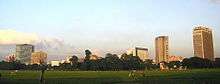
North Kolkata is the oldest part of the city. Characterised by 19th-century architecture and narrow alleyways, it includes areas such as Shyambazar, Shobhabazar, Chitpur, Cossipore, Baranagar, Sinthee, and Dum Dum.[11]:65–66 Central Kolkata hosts the central business district. It contains B. B. D. Bagh, formerly known as Dalhousie Square, and the Esplanade on its east; Strand Road is on its west.[12] The West Bengal Secretariat, General Post Office, Reserve Bank of India, High Court, Lalbazar Police Headquarters, and several other government and private offices are located there. Another business hub is the area south of Park Street, which comprises thoroughfares such as Jawaharlal Nehru Road, Camac Street, Wood Street, Loudon Street, Shakespeare Sarani, and A. J. C. Bose Road.[13] The Maidan is a large open field in the heart of the city that has been called the "lungs of Kolkata"[14] and accommodates sporting events and public meetings.[15] The Victoria Memorial and Kolkata Race Course are located at the southern end of the Maidan. Among the other parks are Central Park in Bidhannagar and Millennium Park on Strand Road, along the Hooghly River.
South Kolkata developed after India gained independence in 1947; it includes upscale neighbourhoods such as Ballygunge, Alipore, New Alipore, Lansdowne, Bhowanipore, Tollygunge, Jodhpur Park, Lake Gardens, Golf Green, Jadavpur, and Kasba.[16] From south-west to south-east, outlying areas include Garden Reach, Behala, Thakurpukur, Kudghat, Ranikuthi, Bansdroni, Baghajatin, and Garia. Two planned townships in the greater Kolkata region are Bidhannagar, also known as Salt Lake City and located north-east of the city; and Rajarhat, also called New Town and sited east of Bidhannagar.[16][17] In the 2000s, Sector V in Bidhannagar developed into a business hub for information technology and telecommunication companies.[18][19] Both Bidhannagar and New Town are situated outside the Kolkata Municipal Corporation limits, in their own municipalities.[17] Fort William, on the western part of the city, houses the headquarters of the Eastern Command of the Indian Army;[20] its premises are under the jurisdiction of the army.
The old Kolkata Business District (CBD) is the seat of the West Bengal Government, and it houses other state government offices as well. The newer CBD is around the south of Park Street, Camac Street (Abanindranath Tagore Sarani) and AJC Bose Road. Several high-rise office blocks including some of Kolkata's tallest commercial buildings — such as the Chatterjee International Centre, Tata Centre, Everest House, Industry House, CGO Building — are located here. The Maidan is a large field situated between the river Ganges and Jawaharlal Nehru Road (earlier called Chowringhee Road). It is said to be the Lungs of Calcutta. The meadow also houses Victoria Memorial, Eden Gardens, and several other sports clubs. In an effort to relieve congestion in the main city, many government offices have shifted to high-rise office buildings lining Bidhan Nagar's Central Park area.
The residential buildings are mainly lowrise and are older colonial buildings and numerous new four storey apartment blocks. Ten to twelve storey apartment blocks have come up in large numbers in south Kolkata. The city has relaxed its rules on highrise construction recently and twenty storey buildings are becoming more common. The tallest residential towers of eastern India — the four thirty-six-storey (G + 35) towers of South City are located on Prince Anwar Shah Road. Huge construction activity along the Eastern Metropolitan Bypass is changing the face of the city. Luxury hotels, convention centres, speciality hospitals, condominium complexes, malls and multiplexes are coming up at a rapid pace.
The neglected western side of the urban agglomeration has got a boost recently with the signing of an agreement with an Indonesian company to build the West Kolkata International Township. Another huge new township is in the proposal state in Dankuni. Slums and dilapidated structures exist in many pockets of the city proper and house over 25% of the city's population (Census 2001). Slum redevelopment schemes have helped improve living conditions to a slight extent but there is huge scope for improvement in this area. Efforts to shift slum dwellers to newer developments have often met with resistance and failure because many of the slums are in prime areas of the city and the slum dwellers who are integrated in the social structure of the neighbourhood do not want to shift. The new metro city is characterised by popular shopping malls, restaurants, coffee shops and entertainment complexes such as the City Centre, Nandan, Tantra, Barista, Sourav's Pavilion and Science City.
Climate
Kolkata has a Tropical wet-and-dry climate climate, with summer monsoons. The annual mean temperature is 26.8 °C (80 °F); monthly mean temperatures range from 19 °C to 30 °C (67 °F to 86 °F) and maximum temperatures can often exceed 40 °C (104 °F) during May–June. Winter tends to last from December to early-February, with the lowest temperatures hovering in the 12 °C — 14 °C range during December and January. The highest recorded temperature is 43 °C (111 °F) and the lowest is 5 °C (41 °F).[21]
Monsoon is the most notable phenomenon in the climate of the city. Maximum rainfall occurs during the monsoon in August (306 mm) and the average annual total is 1,582 mm. Early morning mists and evening smog occur often due to temperature inversions. Summer is dominated by strong southwesterly monsoon winds. The city's total duration of sunshine is 2,528 hours per annum, with the maximum insolation occurring in March.[22] Often during early summer, spells of thunderstorm and heavy rains lashes the city, bringing some relief from the heat and intolerable humidity. These thunderstorms are locally known as Kalbaishakhi (Nor-wester). According to a United Nations Development Programme report, its wind and cyclone zone is "very high damage risk".[5]
Notes
- ↑ Calcuttaweb site
- ↑ Kolkatabirds site
- 1 2 3 Das, Diptendra; Chattopadhyay, B.C. (17–19 December 2009). Characterization of soil over Kolkata municipal area (PDF). Indian Geotechnical Conference. 1. Guntur, India. pp. 11–12. Retrieved 19 November 2012.
- ↑ Bunting, S. W.; Kundu, N.; Mukherjee, M. "Situation analysis. Production systems and natural resources use in PU Kolkata" (PDF). Stirling, UK: Institute of Aquaculture, University of Stirling: 3. Retrieved 26 April 2006.
- 1 2 "Hazard profiles of Indian districts" (PDF). National Capacity Building Project in Disaster Management. UNDP. Archived from the original (PDF) on 19 May 2006. Retrieved 23 August 2006.
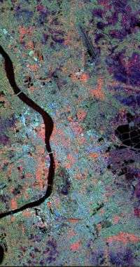
- ↑ "PIA01844: space radar image of Calcutta, West Bengal, India". NASA. 15 April 1999. Retrieved 15 January 2012.
- 1 2 "Introducing KMA" (PDF). Annual Report 2011. Kolkata Metropolitan Development Authority. 2011. Retrieved 9 February 2012.
- 1 2 "007 Kolkata (India)" (PDF). World Association of the Major Metropolises. Retrieved 31 August 2007.
- ↑ Sahdev, Shashi; Verma, Nilima, eds. (2008). "Kolkata—an outline". Urban Land price Scenario- Kolkata − 2008 (DOC). Industry and Economic Planning. Town and Country Planning Organisation, Ministry of Urban Development, Government of India. Retrieved 5 February 2014.
- ↑ Calcutta, West Bengal, India (Map). Mission to planet earth program. NASA. 20 June 1996. Retrieved 25 February 2012.
- ↑ Sahdev, Shashi; Verma, Nilima, eds. (2008). "Trends in land prices in Kolkata". Urban Land price Scenario- Kolkata − 2008 (DOC). Industry and Economic Planning. Town and Country Planning Organisation, Ministry of Urban Development, Government of India. Retrieved 5 February 2014.
- ↑ "Kolkata heritage". Government of West Bengal. Retrieved 27 November 2011.
- ↑ "BSNL may take two weeks to be back online". Times of India. New Delhi. Times News Network (TNN). 9 July 2009. Retrieved 27 November 2011.
With the Camac Street-Park Street-Shakespeare Sarani commercial hub located smack in the middle of the affected zone...
- ↑ Yardley, Jim (27 January 2011). "In city's teeming heart, a place to gaze and graze". The New York Times. New York. Retrieved 27 November 2011.
To Kolkata, it is the 'lungs of the city,' a recharge zone for the soul.
- ↑ Das, Soumitra (21 February 2010). "Maidan marauders". The Telegraph. Kolkata. Retrieved 27 November 2011.
- 1 2 Chakravorty, Sanjoy (2000). "From colonial city to global city? The far-from-complete spatial transformation of Calcutta" (PDF). In Marcuse, Peter; Kempen, Ronald van. Globalizing cities: a new spatial order? (PDF). Oxford, UK: Blackwell Publishing. pp. 56–77. ISBN 0-631-21290-6. Retrieved 26 January 2012.
- 1 2 Chakraborti, Suman (2 November 2011). "Beautification project for Salt Lake, Sec V and New Town". Times of India. New Delhi. Retrieved 6 December 2011.
- ↑ "History of Sector V". Nabadiganta Industrial Township Authority. Retrieved 6 December 2011.
- ↑ "Kolkata! India's new IT hub". Rediff.com. 13 July 2005. Retrieved 6 December 2011.
- ↑ "Eastern Command". Indian Army. Retrieved 25 June 2012.
- ↑ Weatherbase entry for Kolkata
- ↑ GAIA article
22°49′N 88°12′E / 22.82°N 88.20°E