Geography of Guinea-Bissau

This article describes the geography of Guinea-Bissau.
Terrain and ecology

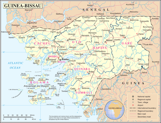
The terrain of Guinea-Bissau is mostly low coastal plain with swamps of Guinean mangroves rising to Guinean forest-savanna mosaic in the east.[1]
The lowest point on Guinea-Bissau is at sea level at the Atlantic Ocean.[1] The highest point on Guinea-Bissau is 300 metres above sea level at an unnamed location in the northeast corner of the country.[1]
Natural resources found in Guinea-Bissau include fish, timber, phosphates, bauxite, clay, granite, limestone and unexploited deposits of petroleum.[1] 10.67% of the land is arable and 235.6 square kilometres is irrigated.[1]
Natural hazards include a hot, dry, dusty harmattan haze that may reduce visibility during the dry season and brush fires.[1] Severe environmental issues include deforestation; soil erosion; overgrazing and overfishing.[1]
Near the Senegal border there have been historic sightings of the painted hunting dog, Lycaon pictus, but that endangered canid may now be extirpated in that locale.[2]
Climate
Guinea-Bissau's climate is tropical. This means it is generally hot and humid. It has a monsoonal-type rainy season (June to November) with southwesterly winds and a dry season (December to May) with northeasterly harmattan winds.[1]
Guinea-Bissau is warm all year around and there is little temperature fluctuation; it averages 26.3 °C (79.3 °F). The average rainfall for the capital city Bissau is 2,024 millimetres (79.7 in) although this is almost entirely accounted for during the rainy season which falls between June and September/October. From December through April, the country receives very little rainfall.

Bissagos Islands
Information from the CIA World Factbook

- Location
- Western Africa, bordering the North Atlantic Ocean, between Guinea and Senegal
- Geographic coordinates
- 12°00′N 15°00′W / 12.000°N 15.000°W
- Map references
- Area
-
- Total: 36,125 km2
- Land: 28,120 km2
- Water: 8,005 km2
- Area—comparative
- Slightly less than three times the size of Connecticut
- Land boundaries
- Coastline
- 350 km
- Maritime claims
-
- Territorial sea: 12 nmi (22.2 km; 13.8 mi)
- Exclusive economic zone: 200 nmi (370.4 km; 230.2 mi)
- Terrain
- Mostly low coastal plain rising to savanna in east
- Elevation extremes
-
- Lowest point: Atlantic Ocean 0 m
- Highest point: Unnamed location in the northeast corner of the country 300 m
- Natural resources
- Fish, timber, phosphates, bauxite, unexploited deposits of petroleum
- Land use
-
- Arable land: 10.67%
- Permanent crops: 8.89%
- Other: 80.44% (2012 est.)
- Irrigated land
- 223.6 km2 (2003)
- Total renewable water resources
- 31 km3
- Freshwater withdrawal (domestic/industrial/agricultural)
-
- Total: 0.18 km3/yr (18%/6%/76%)
- Per capita: 135.7 m3/yr (2005)
- Natural hazards
- Hot, dry, dusty harmattan haze may reduce visibility during dry season; brush fires
- Environment—current issues
- Deforestation; soil erosion; overgrazing; overfishing
- Environment—international agreements
-
- Party to: Biodiversity, Climate Change, Desertification, Endangered Species, Hazardous Wastes, Law of the Sea, Ozone Layer Protection, Wetlands
- Signed, but not ratified: None of the selected agreements[1]
Extreme points
This is a list of the extreme points of Guinea-Bissau, the points that are farther north, south, east or west than any other location.
- Northernmost point – the northern section of the border with Senegal*
- Easternmost point – unnamed location on the border with Guinea immediately south-west of the Guinean village of Sofan, Gabú Region
- Southernmost point – unnamed headland on Ilha Cataque, Tombali Region
- Westernmost point - Cap Roxo at the point where the border with Senegal enters the Atlantic Ocean, Cacheu Region
- *Note: Guinea-Bissau does not have a northern-most point, the border here being formed by a straight horizontal line
See also
Line notes
- 1 2 3 4 5 6 7 8 9 U.S. Central Intelligence Agency. World Factbook
- ↑ C. Michael Hogan. 2009. Painted Hunting Dog: Lycaon pictus, GlobalTwitcher.com, ed. N. Stromberg Archived December 9, 2010, at the Wayback Machine.
References
- C. Michael Hogan. 2009. Painted Hunting Dog: Lycaon pictus, GlobalTwitcher.com, ed. N. Stromberg
- U.S. Central Intelligence Agency.
Guinea-Bissau articles | |||||||
|---|---|---|---|---|---|---|---|
| History |  | ||||||
| Geography | |||||||
| Politics | |||||||
| Economy | |||||||
| Society |
| ||||||
| |||||||