Gaston, Indiana
| Town of Gaston, Indiana | |
|---|---|
| Town | |
|
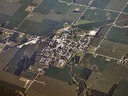
Gaston from the northeast. | |
 Location in the state of Indiana | |
| Coordinates: 40°18′49″N 85°30′3″W / 40.31361°N 85.50083°WCoordinates: 40°18′49″N 85°30′3″W / 40.31361°N 85.50083°W | |
| Country | United States |
| State | Indiana |
| County | Delaware |
| Township | Washington |
| Area[1] | |
| • Total | 0.35 sq mi (0.91 km2) |
| • Land | 0.35 sq mi (0.91 km2) |
| • Water | 0 sq mi (0 km2) |
| Elevation | 886 ft (270 m) |
| Population (2010)[2] | |
| • Total | 871 |
| • Estimate (2012[3]) | 869 |
| • Density | 2,488.6/sq mi (960.9/km2) |
| Time zone | EST (UTC-5) |
| • Summer (DST) | EST (UTC-5) |
| ZIP code | 47342 |
| Area code(s) | 765 |
| FIPS code | 18-27072[4] |
| GNIS feature ID | 0434988[5] |
Gaston is a town in Washington Township, Delaware County, Indiana, United States. The population was 871 at the 2010 census. It is part of the Muncie, IN Metropolitan Statistical Area.
History
Gaston was originally called New Corner, and under the latter name was platted in 1855.[6] The name Gaston was adopted when the railroad was built through the town in 1901.[7]
Geography
Gaston is located at 40°18′49″N 85°30′3″W / 40.31361°N 85.50083°W (40.313547, -85.500848).[8]
According to the 2010 census, Gaston has a total area of 0.35 square miles (0.91 km2), all land.[1]
Demographics
| Historical population | |||
|---|---|---|---|
| Census | Pop. | %± | |
| 1910 | 638 | — | |
| 1920 | 541 | −15.2% | |
| 1930 | 654 | 20.9% | |
| 1940 | 677 | 3.5% | |
| 1950 | 729 | 7.7% | |
| 1960 | 801 | 9.9% | |
| 1970 | 928 | 15.9% | |
| 1980 | 1,150 | 23.9% | |
| 1990 | 979 | −14.9% | |
| 2000 | 1,010 | 3.2% | |
| 2010 | 871 | −13.8% | |
| Est. 2015 | 865 | [9] | −0.7% |
2010 census
As of the census[2] of 2010, there were 871 people, 331 households, and 230 families residing in the town. The population density was 2,488.6 inhabitants per square mile (960.9/km2). There were 392 housing units at an average density of 1,120.0 per square mile (432.4/km2). The racial makeup of the town was 97.0% White, 0.1% African American, 0.1% Asian, 0.6% from other races, and 2.2% from two or more races. Hispanic or Latino of any race were 2.9% of the population.
There were 331 households of which 42.9% had children under the age of 18 living with them, 44.7% were married couples living together, 18.4% had a female householder with no husband present, 6.3% had a male householder with no wife present, and 30.5% were non-families. 24.2% of all households were made up of individuals and 8.1% had someone living alone who was 65 years of age or older. The average household size was 2.63 and the average family size was 3.06.
The median age in the town was 34.4 years. 29.6% of residents were under the age of 18; 7.8% were between the ages of 18 and 24; 28.4% were from 25 to 44; 23.8% were from 45 to 64; and 10.3% were 65 years of age or older. The gender makeup of the town was 48.0% male and 52.0% female.
2000 census
As of the census[4] of 2000, there were 1,010 people, 351 households, and 261 families residing in the town. The population density was 2,881.0 people per square mile (1,114.2/km²). There were 376 housing units at an average density of 1,072.5 per square mile (414.8/km²). The racial makeup of the town was 98.22% White, 0.59% African American, and 1.19% from two or more races. Hispanic or Latino of any race were 0.20% of the population.
There were 351 households out of which 44.4% had children under the age of 18 living with them, 51.3% were married couples living together, 17.4% had a female householder with no husband present, and 25.4% were non-families. 21.1% of all households were made up of individuals and 9.1% had someone living alone who was 65 years of age or older. The average household size was 2.67 and the average family size was 3.06.
In the town the population was spread out with 29.7% under the age of 18, 6.3% from 18 to 24, 31.6% from 25 to 44, 22.2% from 45 to 64, and 10.2% who were 65 years of age or older. The median age was 34 years. For every 100 females there were 102.4 males. For every 100 females age 18 and over, there were 100.6 males.
The median income for a household in the town was $31,853, and the median income for a family was $37,583. Males had a median income of $28,558 versus $23,281 for females. The per capita income for the town was $15,357. About 10.5% of families and 11.8% of the population were below the poverty line, including 18.3% of those under age 18 and 6.4% of those age 65 or over.
References
- 1 2 "G001 - Geographic Identifiers - 2010 Census Summary File 1". United States Census Bureau. Retrieved 2015-07-16.
- 1 2 "American FactFinder". United States Census Bureau. Retrieved 2012-12-11.
- ↑ "Population Estimates". United States Census Bureau. Retrieved 2013-06-25.
- 1 2 "American FactFinder". United States Census Bureau. Retrieved 2008-01-31.
- ↑ "US Board on Geographic Names". United States Geological Survey. 2007-10-25. Retrieved 2008-01-31.
- ↑ Lasley, Norma (2012). Delaware County. Arcadia Publishing. p. 47. ISBN 978-0-7385-9430-9.
- ↑ Kemper, William Harrison (1908). A Twentieth Century History of Delaware County, Indiana, Volume 1. Lewis Publishing Company. p. 165.
- ↑ "US Gazetteer files: 2010, 2000, and 1990". United States Census Bureau. 2011-02-12. Retrieved 2011-04-23.
- ↑ "Annual Estimates of the Resident Population for Incorporated Places: April 1, 2010 to July 1, 2015". Retrieved July 2, 2016.
- ↑ "Census of Population and Housing". Census.gov. Retrieved June 4, 2015.
Municipalities and communities of Delaware County, Indiana, United States | ||
|---|---|---|
| City | ||
| Towns | ||
| Townships | ||
| Unincorporated communities | ||
| Footnotes | ‡This populated place also has portions in an adjacent county or counties | |