Gassol
| Gassol | |
|---|---|
| LGA | |
 Gassol Location in Nigeria | |
| Coordinates: 8°24′N 10°32′E / 8.400°N 10.533°ECoordinates: 8°24′N 10°32′E / 8.400°N 10.533°E | |
| Country |
|
| State | Taraba State |
| Area | |
| • Total | 5,548 km2 (2,142 sq mi) |
| Population (2006 census) | |
| • Total | 244,749 |
| Time zone | WAT (UTC+1) |
| 3-digit postal code prefix | 620 |
| ISO 3166 code | NG.TA.GS |
Gassol is a Local Government Area in Taraba State, Nigeria. Its headquarters are in the town of Mutum Biyu (or Mutumbiyu or Mutum Mbiyu) on the A4 highway at8°38′00″N 10°46′00″E / 8.63333°N 10.76667°E.
It has an area of 5,548 km² and a population of 244,749 at the 2006 census.
The postal code of the area is 672.[1]
The northern border of Gassol is the Benue River and the Taraba River flows north through the area to its confluence with the Benue.
Gassol is one of the eight LGAs of Taraba State whose majority population is the Mumuye people.
On 28 June, 2014, the Taraba State police command in Jalingo said "unknown gunmen" had "attacked and killed 10 persons who were coming from Garba Chade to Maihula village" in Gassol LGA.[2]
References
- ↑ "Post Offices- with map of LGA". NIPOST. Retrieved 2009-10-20.
- ↑ Midat Joseph; Obed Minchakpu; Andrew Ojih (2014-06-29). "Nigeria: 52 Killed in Kaduna, Bauchi, Taraba Attacks". Leadership (Abuja) - allAfrica.com. Retrieved 2014-06-30.
State capital: Jalingo | ||
| LGAs | 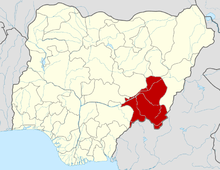 | |