Gas City, Indiana
| Gas City | |
|---|---|
| City | |
| City of Gas City | |
|
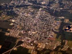
Aerial view of Gas City facing southwest | |
 Location in the state of Indiana | |
| Coordinates: 40°29′17″N 85°36′20″W / 40.48806°N 85.60556°WCoordinates: 40°29′17″N 85°36′20″W / 40.48806°N 85.60556°W | |
| Country | United States |
| State | Indiana |
| County | Grant |
| Government | |
| • Mayor | Howard Larry Leach (D) |
| Area[1] | |
| • Total | 4.56 sq mi (11.81 km2) |
| • Land | 4.56 sq mi (11.81 km2) |
| • Water | 0 sq mi (0 km2) |
| Elevation | 856 ft (261 m) |
| Population (2010)[2] | |
| • Total | 5,965 |
| • Estimate (2012[3]) | 5,909 |
| • Density | 1,308.1/sq mi (505.1/km2) |
| Time zone | EST (UTC-5) |
| • Summer (DST) | EDT (UTC-4) |
| ZIP code | 46933 |
| Area code(s) | 765 |
| FIPS code | 18-27054[4] |
| GNIS feature ID | 0434985[5] |
| Website | http://www.gascityindiana.com/ |
Gas City is a city in Grant County, Indiana, along the Mississinewa River. The population was 5,965 at the 2010 census.
History
It was first known as Harrisburg when settled on May 25, 1867 by Noah Harris. It became something of a boom town when natural gas was found in the area in 1887. The Gas City Land Company was founded on March 21, 1892 and the town of about 150 people changed its name to Gas City a few days later.[6] However, as of 2012 much of the gas is depleted. (See Indiana Gas Boom.)
The Gas City High School, Thompson-Ray House, and West Ward School are listed on the National Register of Historic Places.[7]
Geography
Gas City is located at 40°29′17″N 85°36′20″W / 40.48806°N 85.60556°W (40.488190, -85.605649).[8]
According to the 2010 census, Gas City has a total area of 4.56 square miles (11.81 km2), all land.[1]
Demographics
| Historical population | |||
|---|---|---|---|
| Census | Pop. | %± | |
| 1880 | 145 | — | |
| 1890 | 145 | 0.0% | |
| 1900 | 3,622 | 2,397.9% | |
| 1910 | 3,224 | −11.0% | |
| 1920 | 2,870 | −11.0% | |
| 1930 | 3,087 | 7.6% | |
| 1940 | 3,488 | 13.0% | |
| 1950 | 3,787 | 8.6% | |
| 1960 | 4,469 | 18.0% | |
| 1970 | 5,742 | 28.5% | |
| 1980 | 6,370 | 10.9% | |
| 1990 | 6,296 | −1.2% | |
| 2000 | 5,940 | −5.7% | |
| 2010 | 5,965 | 0.4% | |
| Est. 2015 | 5,968 | [9] | 0.1% |
2010 census
As of the census[2] of 2010, there were 5,965 people, 2,410 households, and 1,632 families residing in the city. The population density was 1,308.1 inhabitants per square mile (505.1/km2). There were 2,597 housing units at an average density of 569.5 per square mile (219.9/km2). The racial makeup of the city was 96.2% White, 0.9% African American, 0.3% Native American, 0.4% Asian, 0.4% from other races, and 1.7% from two or more races. Hispanic or Latino of any race were 2.4% of the population.
There were 2,410 households of which 34.0% had children under the age of 18 living with them, 47.2% were married couples living together, 15.1% had a female householder with no husband present, 5.4% had a male householder with no wife present, and 32.3% were non-families. 27.4% of all households were made up of individuals and 11.6% had someone living alone who was 65 years of age or older. The average household size was 2.45 and the average family size was 2.92.
The median age in the city was 39.4 years. 24.6% of residents were under the age of 18; 7.4% were between the ages of 18 and 24; 25.6% were from 25 to 44; 27.1% were from 45 to 64; and 15.4% were 65 years of age or older. The gender makeup of the city was 48.2% male and 51.8% female.
2000 census
As of the census[4] of 2000, there were 5,940 people, 2,393 households, and 1,643 families residing in the city. The population density was 1,599.2 people per square mile (618.2/km²). There were 2,497 housing units at an average density of 672.3 per square mile (259.9/km²). The racial makeup of the city was 97.46% White, 0.30% African American, 0.32% Native American, 0.22% Asian, 0.07% Pacific Islander, 0.56% from other races, and 1.08% from two or more races. Hispanic or Latino of any race were 1.52% of the population.
There were 2,393 households out of which 31.4% had children under the age of 18 living with them, 52.1% were married couples living together, 12.6% had a female householder with no husband present, and 31.3% were non-families. 26.8% of all households were made up of individuals and 10.9% had someone living alone who was 65 years of age or older. The average household size was 2.46 and the average family size was 2.95.
In the city the population was spread out with 25.2% under the age of 18, 8.2% from 18 to 24, 29.1% from 25 to 44, 23.8% from 45 to 64, and 13.6% who were 65 years of age or older. The median age was 37 years. For every 100 females there were 90.2 males. For every 100 females age 18 and over, there were 84.1 males.
The median income for a household in the city was $35,940, and the median income for a family was $42,056. Males had a median income of $34,020 versus $23,482 for females. The per capita income for the city was $18,295. About 8.1% of families and 10.2% of the population were below the poverty line, including 13.8% of those under age 18 and 8.3% of those age 65 or over.
Transport
Gas City is served by several state and federal routes:
-
 Interstate 69 (exit 259)
 -
 U.S. Route 35
 -
 State Road 22
References
- 1 2 "G001 - Geographic Identifiers - 2010 Census Summary File 1". United States Census Bureau. Retrieved 2015-07-28.
- 1 2 "American FactFinder". United States Census Bureau. Retrieved 2012-12-11.
- ↑ "Population Estimates". United States Census Bureau. Retrieved 2013-06-25.
- 1 2 "American FactFinder". United States Census Bureau. Retrieved 2008-01-31.
- ↑ "US Board on Geographic Names". United States Geological Survey. 2007-10-25. Retrieved 2008-01-31.
- ↑ "Gas City History". City of Gas City, IN. Retrieved 12 September 2014.
- ↑ National Park Service (2010-07-09). "National Register Information System". National Register of Historic Places. National Park Service.
- ↑ "US Gazetteer files: 2010, 2000, and 1990". United States Census Bureau. 2011-02-12. Retrieved 2011-04-23.
- ↑ "Annual Estimates of the Resident Population for Incorporated Places: April 1, 2010 to July 1, 2015". Retrieved July 2, 2016.
- ↑ "Census of Population and Housing". Census.gov. Retrieved June 4, 2015.
External links
Municipalities and communities of Grant County, Indiana, United States | ||
|---|---|---|
| Cities | ||
| Towns | ||
| Townships | ||
| CDPs | ||
| Unincorporated communities | ||
| Footnotes | ‡This populated place also has portions in an adjacent county or counties | |