Garrett Township, Douglas County, Illinois
| Garrett Township | |
|---|---|
| Township | |
 Location in Douglas County | |
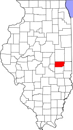 Douglas County's location in Illinois | |
| Coordinates: 39°49′15″N 88°23′57″W / 39.82083°N 88.39917°WCoordinates: 39°49′15″N 88°23′57″W / 39.82083°N 88.39917°W | |
| Country |
|
| State |
|
| County | Douglas |
| Established | November 5, 1867 |
| Area | |
| • Total | 52.35 sq mi (135.6 km2) |
| • Land | 52.23 sq mi (135.3 km2) |
| • Water | 0.13 sq mi (0.3 km2) 0.25% |
| Elevation | 673 ft (205 m) |
| Population (2010) | |
| • Total | 1,441 |
| • Density | 27.6/sq mi (10.7/km2) |
| Time zone | CST (UTC-6) |
| • Summer (DST) | CDT (UTC-5) |
| ZIP codes | 61872, 61911, 61913, 61953 |
| GNIS feature ID | 0429043 |
Garrett Township is one of nine townships in Douglas County, Illinois, USA. As of the 2010 census, its population was 1,441 and it contained 613 housing units.[1]
Geography
According to the 2010 census, the township has a total area of 52.35 square miles (135.6 km2), of which 52.23 square miles (135.3 km2) (or 99.77%) is land and 0.13 square miles (0.34 km2) (or 0.25%) is water.[1]
Cities, towns, villages
Unincorporated towns
- Chicken Bristle at 39°50′10″N 88°22′00″W / 39.836143°N 88.366719°W
- Ficklin at 39°47′55″N 88°21′19″W / 39.798643°N 88.355329°W
Cemeteries
The township contains these four cemeteries: Lewis, Lower Lester, Taylor and Upper Lester.
Major highways
Airports and landing strips
- Bragg Landing Strip
- Cooch Landing Area
- Kamm Airport
School districts
- Atwood-Hammond Community Unit School District 39
- Tuscola Community Unit School District 301
Political districts
- State House District 110
- State Senate District 55
References
- "Garrett Township, Douglas County, Illinois". Geographic Names Information System. United States Geological Survey. Retrieved 2010-01-17.
- United States Census Bureau 2009 TIGER/Line Shapefiles
- United States National Atlas
- 1 2 "Population, Housing Units, Area, and Density: 2010 - County -- County Subdivision and Place -- 2010 Census Summary File 1". United States Census. Retrieved 2013-05-28.
External links

Municipalities and communities of Douglas County, Illinois, United States | ||
|---|---|---|
| Cities | ||
| Villages | ||
| Townships | ||
| Unincorporated communities | ||
| Ghost town | ||
| Footnotes | ‡This populated place also has portions in an adjacent county or counties | |
This article is issued from Wikipedia - version of the 12/4/2013. The text is available under the Creative Commons Attribution/Share Alike but additional terms may apply for the media files.