Ganyu District
| Ganyu 赣榆区 | |
|---|---|
| District | |
 Administrative boundaries in eastern China; provincial boundaries in blue | |
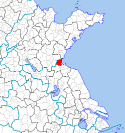
 Ganyu Location in Jiangsu | |
| Coordinates: 34°54′00″N 119°02′10″E / 34.900°N 119.036°ECoordinates: 34°54′00″N 119°02′10″E / 34.900°N 119.036°E[1] | |
| Country | People's Republic of China |
| Province | Jiangsu |
| Prefecture-level city | Lianyungang |
| Township-level divisions | 18 towns |
| Seat | Qingkou (青口镇) |
| Area | |
| • Total | 1,363 km2 (526 sq mi) |
| Population (2010) | |
| • Total | 949,400 |
| • Density | 700/km2 (1,800/sq mi) |
| Time zone | China Standard (UTC+8) |
| Postal code | 222100 |
| Area code(s) | 0518 |
Ganyu District (simplified Chinese: 赣榆区; traditional Chinese: 贛榆區; pinyin: Gànyú Qū) is under the administration of Lianyungang, Jiangsu province, China. It contains the province's northernmost point and is located along the Yellow Sea coast where the coastline takes a sharp turn toward the southeast, and borders the Shandong prefecture-level cities of Linyi and Rizhao to the north.
Geography and climate
| Climate data for Ganyu County (1971–2000) | |||||||||||||
|---|---|---|---|---|---|---|---|---|---|---|---|---|---|
| Month | Jan | Feb | Mar | Apr | May | Jun | Jul | Aug | Sep | Oct | Nov | Dec | Year |
| Average high °C (°F) | 4.5 (40.1) |
6.5 (43.7) |
11.5 (52.7) |
18.5 (65.3) |
23.9 (75) |
27.5 (81.5) |
29.9 (85.8) |
29.5 (85.1) |
26.0 (78.8) |
20.9 (69.6) |
13.6 (56.5) |
7.1 (44.8) |
18.3 (64.9) |
| Average low °C (°F) | −3.9 (25) |
−2.1 (28.2) |
2.3 (36.1) |
8.4 (47.1) |
13.8 (56.8) |
19.3 (66.7) |
23.3 (73.9) |
22.8 (73) |
17.6 (63.7) |
11.2 (52.2) |
4.2 (39.6) |
−1.9 (28.6) |
9.6 (49.2) |
| Average precipitation mm (inches) | 18.0 (0.709) |
20.9 (0.823) |
32.4 (1.276) |
47.2 (1.858) |
68.4 (2.693) |
103.9 (4.091) |
237.3 (9.343) |
204.9 (8.067) |
79.1 (3.114) |
48.2 (1.898) |
32.3 (1.272) |
13.3 (0.524) |
905.9 (35.668) |
| Average precipitation days (≥ 0.1 mm) | 4.0 | 5.2 | 6.4 | 6.6 | 8.3 | 8.6 | 14.0 | 11.0 | 7.6 | 6.6 | 5.4 | 3.6 | 87.3 |
| Average relative humidity (%) | 67 | 67 | 68 | 68 | 72 | 77 | 85 | 84 | 77 | 72 | 69 | 67 | 72.8 |
| Mean monthly sunshine hours | 175.5 | 172.9 | 204.9 | 227.5 | 254.8 | 226.9 | 208.1 | 234.0 | 219.0 | 211.8 | 181.2 | 178.8 | 2,495.4 |
| Percent possible sunshine | 56 | 56 | 56 | 58 | 59 | 53 | 47 | 56 | 59 | 60 | 58 | 59 | 56.4 |
| Source: China Meteorological Administration | |||||||||||||
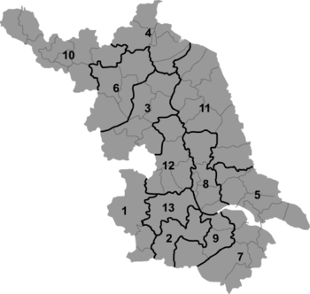
Administrative divisions
There are 18 towns in the district:[2]
|
|
References
- ↑ Google (2014-07-02). "Ganyu" (Map). Google Maps. Google. Retrieved 2014-07-02.
- ↑ 2011年统计用区划代码和城乡划分代码:赣榆县 (in Chinese). National Bureau of Statistics of the People's Republic of China. Retrieved 2013-02-21.
- www.xzqh.org (Chinese)
This article is issued from Wikipedia - version of the 11/21/2014. The text is available under the Creative Commons Attribution/Share Alike but additional terms may apply for the media files.