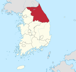
Gangwon Province (South Korea)
Coordinates: 37°30′N 128°15′E / 37.500°N 128.250°E
- For the province in North Korea that bears the same name but different romanisation, see Kangwon Province (North Korea).
| Gangwon Province 강원도 | |||
|---|---|---|---|
| Province | |||
| Korean transcription(s) | |||
| • Hangul | 강원도 | ||
| • Hanja | 江原道 | ||
| • McCune‑Reischauer | Kangwŏndo | ||
| • Revised Romanization | Gangwon-do | ||
| |||
 | |||
| Country | South Korea | ||
| Region |
Gwandong (Yeongseo: western Gangwon; Yeongdong: eastern Gangwon) | ||
| Capital | Chuncheon | ||
| Subdivisions | 7 cities; 11 counties | ||
| Government | |||
| • Governor | Choi Moon-soon | ||
| Area | |||
| • Total | 20,569 km2 (7,942 sq mi) | ||
| Area rank | 2nd | ||
| Population (October, 2014) | |||
| • Total | 1,542,147[1] | ||
| • Rank | 8th | ||
| • Density | 75.4/km2 (195/sq mi) | ||
| Metropolitan Symbols | |||
| • Flower | Royal azalea[2] | ||
| • Tree | Korean pine | ||
| • Bird | Red-crowned crane | ||
| Dialect |
Gangwon (Yeongseo: western Gangwon dialect; Yeongdong: eastern Gangwon dialect) | ||
| Website | gwd.go.kr | ||


Gangwon-do (Korean pronunciation: [kaŋwʌndo]) is a province of South Korea, with its capital at Chuncheon. Before the division of Korea in 1945, Gangwon and its North Korean neighbor Kangwŏn formed a single province.
In 2010 actor So Ji-sub was appointed a goodwill ambassador for tourism for Gangwon Province.[3]
History
Gangwon-do was one of the Eight Provinces of Korea during the Joseon Dynasty. The province was formed in 1395, and derived its name from the names of the principal cities of Gangneung (강릉; 江陵) and the provincial capital Wonju (원주; 原州).
In 1895 Gangwon-do was replaced by the Districts of Chuncheon (Chuncheon-bu; 춘천부; 春川府) in the west and Gangneung (Gangneung-bu; 강릉부; 江陵府) in the east. (Wonju became part of Chungju District.)
In 1896 Korea was redivided into thirteen provinces, and the two districts were merged to re-form Gangwon-do Province. Although Wonju rejoined Gangwon-do province, the provincial capital was moved to Chuncheon, where it remains today.
In 1945 Gangwon-do (along with the rest of Korea) was divided by the 38th parallel north in 1945 into U.S. American and Soviet zones of occupation in the south and north respectively, which led to Wonsan joining the province's northern half in 1946 to serve as its administrative center. In 1948, the southern half of the province became part of the new Republic of Korea. As a result of the Korean War Armistice Agreement of 1953, the boundary between the South and North Korean portions of the province was shifted northward to the Military Demarcation Line.
Geography
Location
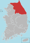
Gangwon-do is bounded on the west by Gyeonggi-do province, on the south by the provinces of Chungcheongbuk-do and Gyeongsangbuk-do.To the north lies the province's North Korean counterpart, Kangwŏn province. The province's landscape is dominated by the Taebaek Mountains (Taebaek Sanmaek) which almost reach the sea. As a consequence the coast is steep.
Regions
Gangwon-do and its North Korean counterpart Kangwŏn are together referred to as the Gwandong region. The region west of the Taebaek Mountains is called Yeongseo, while the region east of the mountains is called Yeongdong. The term "Yeongdong" is frequently used in reference to transportation services from Seoul, the national capital. Thus, one might catch a bus or train on the "Yeongdong Line," or drive to Gangneung on the Yeongdong Expressway.
Resources
The area of Gangwon-do is 20,569 km2 (7,941.74 sq mi),[4] of which four fifths are woodland. Edible alpine plants and mushrooms are harvested in these forests. The province is renowned for its agricultural produce, in particular potatoes and fish (cuttlefish and pollock). Mineral resources of the province include iron, coal, fluorite, limestone and tungsten. There are hydroelectric and thermoelectric power plants.
Cities
The main cities in the province are Chuncheon (the provincial capital), Gangneung, Sokcho, Wonju, and Donghae.
Landmarks
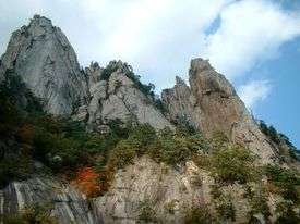
Seoraksan (mountain; 1,708 m) and Mt. Odae (1,563 m) with its ski run, attract a large number of national tourists. Both are located in national parks in the Taebaek Mountains. South Korea's largest limestone cave, Hwanseongul, receives over one million visitors a year.
Climate
The climate of Gangwon-do is influenced by the latitude. In summer along with the higher temperature and there is high humidity, but in winter the weather can be very cold owing to high pressure from the east of the Asian continent.
The climate of Gangwon-do can have many differences between Yeongseo and Yeongdong. Yeongdong's average temperature is higher than Yeongseo's, and Yeongseo's average amount of precipitation is lower than Yeongdong's. Violent winds are common in winter and spring, so Gangwon-do's average wind speed is faster than in other provinces. Sometimes huge amounts of snow can fall, especially in Yeongdong.
Religion
Religion in Gangwon (2005)[5]
According to the census of 2005, of the people of Gangwon 23% follow Buddhism and 24.7% follow Christianity (15.6% Protestantism and 9.1% Catholicism).[5] 52.3% of the population is mostly not religious or follow Muism and other indigenous religions.
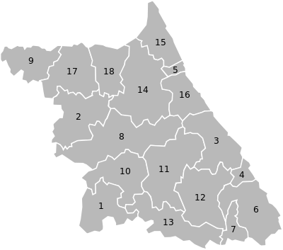
Administrative divisions
Gangwon-do is divided into 7 cities (si) and 11 counties (gun). The names below are given in English, hangul, and hanja.
| Map | # | Name | Hangul | Hanja | Population (2012)[2] | Subdivisions |
|---|---|---|---|---|---|---|
 | ||||||
| — City — | ||||||
| 1 | Wonju | 원주시 | 原州市 | 326,321 | 1 eup, 8 myeon, 16 haengjeong-dong | |
| 2 | Chuncheon (Capital city) | 춘천시 | 春川市 | 276,131 | 1 eup, 9 myeon, 15 haengjeong-dong | |
| 3 | Gangneung | 강릉시 | 江陵市 | 219,274 | 1 eup, 7 myeon, 13 haengjeong-dong | |
| 4 | Donghae | 동해시 | 東海市 | 94,440 | 10 haengjeong-dong | |
| 5 | Sokcho | 속초시 | 束草市 | 84,279 | 8 haengjeong-dong | |
| 6 | Samcheok | 삼척시 | 三陟市 | 73,194 | 2 eup, 6 myeon, 4 haengjeong-dong | |
| 7 | Taebaek | 태백시 | 太白市 | 49,756 | 8 haengjeong-dong | |
| — County — | ||||||
| 8 | Hongcheon County | 홍천군 | 洪川郡 | 70,401 | 1 eup, 9 myeon | |
| 9 | Cheorwon County | 철원군 | 鐵原郡 | 48,469 | 4 eup, 7 myeon | |
| 10 | Hoengseong County | 횡성군 | 橫城郡 | 45,104 | 1 eup, 8 myeon | |
| 11 | Pyeongchang County | 평창군 | 平昌郡 | 43,912 | 1 eup, 7 myeon | |
| 12 | Jeongseon County | 정선군 | 旌善郡 | 40,240 | 4 eup, 5 myeon | |
| 13 | Yeongwol County | 영월군 | 寧越郡 | 40,439 | 2 eup, 7 myeon | |
| 14 | Inje County | 인제군 | 麟蹄郡 | 32,769 | 1 eup, 5 myeon | |
| 15 | Goseong County | 고성군 | 高城郡 | 26,753 | 2 eup, 4 myeon | |
| 16 | Yangyang County | 양양군 | 襄陽郡 | 28,053 | 1 eup, 5 myeon | |
| 17 | Hwacheon County | 화천군 | 華川郡 | 25,194 | 1 eup, 4 myeon | |
| 18 | Yanggu County | 양구군 | 楊口郡 | 23,039 | 1 eup, 4 myeon | |
Claimed
Produce
Food
- List of the Gangwon-origin food famous among the nation.
See also
References
- ↑ http://rcps.egov.go.kr:8081/ageStat.do?command=month
- 1 2 인구 및 세대 (in Korean). Gangwon Province. Retrieved 10 June 2013.
- ↑ "So Ji-sub to Promote Tourism in Gangwon Province". Chosun Ilbo. 3 September 2010. Retrieved 6 July 2012.
- ↑ "Natural Environment". Gangwon Province. Retrieved 18 March 2013.
- 1 2 2005 Census - Religion Results
External links
| Wikimedia Commons has media related to Gangwon-do. |
 Gangwon travel guide from Wikivoyage
- Official Provincial Homepage
- 2018 Pyeongchang Winter Olympics, Official Homepage
| Regions | |
|---|---|
| Provinces | |
| Special self-governing province | |
| Special city | |
| Special self-governing city | |
| Metropolitan cities | |
| The Committee for the Five Northern Korean Provinces | |
Host cities of Asian Games | ||
|---|---|---|
| Summer | ||
| Winter | ||