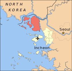
Ganghwa County
| Ganghwa 강화군 | |
|---|---|
| County | |
| Korean transcription(s) | |
| • Hanja | 江華郡 |
| • Revised Romanization | Ganghwa-gun |
| • McCune-Reischauer | Kanghwa-kun |
 | |
 | |
| Country | South Korea |
| Region | Sudogwon |
| Provincial level | Incheon |
| Administrative divisions | 1 eup, 13 myeon, 96 ri |
| Area | |
| • Total | 411.2 km2 (158.8 sq mi) |
| Population | |
| • Dialect | Seoul |
| Website | Ganghwa County Office |
Ganghwa County is a county in Incheon Metropolitan City, South Korea, where Ganghwa Island, as well the minor islands around it, is located.
History
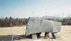
Ganghwa has been recognized as preserved most important history of peninsula from the prehistoric age to modern times. Relics and remains of prehistoric age, old stone age and new stone age were found of their various vestiges in Jangjeongni, Sagiri, Dongmangni and others respectively in the symbolic huge stone relics of Bronze Age, more than 80 dolmens were discovered in the vicinity of Bugeunni and neighbouring area, of which giant tombs revealed the existence of inhabitant there.
Dangun, the founder of Gojoseon, is said to have made an altar on top of Mani-san and offered sacrifices to his ancestors.[1]
In the 9th century, Unified Silla established a garrison on the island to combat piracy. The commander Wang Geon established his military reputation at the garrison, later going on to found the kingdom of Goryeo. In the 13th century, the court of Goryeo took refuge on the island as Mongol forces invaded in 1232. After Goryeo capitulated to the Mongols, the elite forces on the island rose up, beginning the Sambyeolcho Rebellion.
In the early 19th century, Catholicism was introduced into Korea despite its official proscription by the Korean court. The Korean court clamped down on the illicit French missionaries, massacring French Catholic missionaries and Korean converts alike. At the first battle, the Korean infantry division lost heavily, and General Yang Heon-su concluded that only a large cavalry division could stand up to French firepower. An ambush by Korean forces on a French party attempting to occupy the strategically located Cheondeung Temple (전등사, 傳燈寺) on the island‘s south coast resulted in French casualties. French realization that they were far outnumbered and outgunned forced them to abandon the island and their expedition.
In 1871, following the General Sherman Incident, the United States Navy launched an expedition on the soldiers at Ganghwa Island, resulting in the Battle of Ganghwa.
In 1875 a Japanese ship, Unyo, explored into the restricted areas in name of measuring the coastline, and fired a few shots at the fortress on the island. When a crew boat was sent to the island, Koreans fired a few shots back (Ganghwa Island incident). The Japanese argued that this was an aggression and demanded a treaty. Early in the following year, Japan sent a large force of the Imperial Japanese Navy, and the Treaty of Ganghwa was concluded. That agreement, concluded on Ganghwa Island, officially opened Korea to Japanese external trade for the first time during the 19th century.
Ganghwa was raised to the status of a county in 1906, and incorporated into the Incheon Metropolitan City in 1995.
Climate
| Climate data for Ganghwa (1981–2010) | |||||||||||||
|---|---|---|---|---|---|---|---|---|---|---|---|---|---|
| Month | Jan | Feb | Mar | Apr | May | Jun | Jul | Aug | Sep | Oct | Nov | Dec | Year |
| Average high °C (°F) | 1.2 (34.2) |
4.1 (39.4) |
9.4 (48.9) |
16.3 (61.3) |
21.3 (70.3) |
25.4 (77.7) |
27.5 (81.5) |
29.0 (84.2) |
25.3 (77.5) |
19.3 (66.7) |
11.2 (52.2) |
4.1 (39.4) |
16.2 (61.2) |
| Daily mean °C (°F) | −3.8 (25.2) |
−1.0 (30.2) |
4.3 (39.7) |
10.7 (51.3) |
15.9 (60.6) |
20.3 (68.5) |
23.5 (74.3) |
24.5 (76.1) |
19.8 (67.6) |
13.4 (56.1) |
6.0 (42.8) |
−0.8 (30.6) |
11.1 (52) |
| Average low °C (°F) | −8.7 (16.3) |
−6.1 (21) |
−0.9 (30.4) |
5.1 (41.2) |
10.8 (51.4) |
15.8 (60.4) |
20.4 (68.7) |
20.8 (69.4) |
15.1 (59.2) |
7.8 (46) |
0.8 (33.4) |
−5.6 (21.9) |
6.3 (43.3) |
| Average precipitation mm (inches) | 17.7 (0.697) |
19.2 (0.756) |
39.6 (1.559) |
66.9 (2.634) |
108.8 (4.283) |
123.4 (4.858) |
358.2 (14.102) |
326.6 (12.858) |
165.4 (6.512) |
51.2 (2.016) |
50.7 (1.996) |
18.8 (0.74) |
1,346.7 (53.02) |
| Average precipitation days (≥ 0.1 mm) | 5.7 | 4.7 | 6.2 | 6.7 | 8.4 | 8.7 | 13.9 | 12.0 | 7.3 | 5.7 | 7.0 | 6.6 | 92.9 |
| Average relative humidity (%) | 66.1 | 63.0 | 62.9 | 62.8 | 69.5 | 75.3 | 82.7 | 80.3 | 74.8 | 69.9 | 68.2 | 67.3 | 70.2 |
| Mean monthly sunshine hours | 179.8 | 188.3 | 218.3 | 233.3 | 241.4 | 221.0 | 173.2 | 201.3 | 214.4 | 220.4 | 170.0 | 165.9 | 2,431.5 |
| Source: Korea Meteorological Administration[2] | |||||||||||||
Speciality
About 70% of Ganghwa's citizens are engaged in farming, mainly rice. Fishery and forestry are other occupations practiced.
Hwamunseok is a well-known traditional fancy matting. Since the Goryeo dynasty (10th-14th centuries), hwamunseok has been produced and exported to China and Japan. The mats are produced in the home handicraft industry. Under an order given by the royal court of the Joseon dynasty over 100 years ago, craftsman Han Chunggyo from the white-mat producing village, Yango-ri, Haesongmyeon, Ganghwa-gun, achieved a successful product by the design of his own idea. Thereafter, various designs have been developed and manufacturing techniques have been improved.[3]
The Ganghwa turnip is a specialty of the area. It has been cultivated since the 5th century. This is recorded in the 17th-century Dongui Bogam book of oriental medicine."[4]
World Heritages
In Ganghwa county, dolmens are registered by UNESCO as a World Heritage Site. In three regions of South Korea including Hwasun and Gochang, Ganghwa's dolmens are famous sites to study ancient culture.
Administrative Divisions of Ganghwa-gun
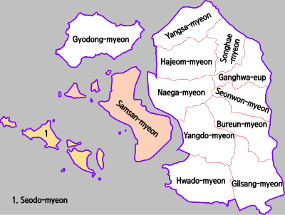
- Ganghwa-eup (강화읍)
- Seonwon-myeon (선원면)
- Bureun-myeon (불은면)
- Gilsang-myeon (길상면)
- Hwado-myeon (화도면)
- Yangdo-myeon (양도면)
- Naega-myeon (내가면)
- Hajeom-myeon (하점면)
- Yangsa-myeon (양사면)
- Songhae-myeon (송해면)
- Gyodong-myeon (교동면)
- Samsan-myeon (삼산면)
- Seodo-myeon (서도면)
Sister cities
References
- ↑ Korean Foundation Myth
- ↑ "평년값자료(1981–2010) 강화(201)". Korea Meteorological Administration. Retrieved 2011-05-11.
- ↑ Official page of Ganghwa
- ↑ Ganghwa County
External links
Coordinates: 37°44′20″N 126°29′22″E / 37.73889°N 126.48944°E