Góis
| Góis | |||
|---|---|---|---|
| Municipality | |||
|
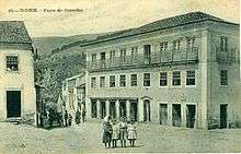
The Church of Santa Maria Maior in Góis | |||
| |||
 | |||
| Coordinates: 40°9′17″N 8°6′38″W / 40.15472°N 8.11056°WCoordinates: 40°9′17″N 8°6′38″W / 40.15472°N 8.11056°W | |||
| Country |
| ||
| Region | Centro | ||
| Subregion | Pinhal Interior Norte | ||
| Intermunic. comm. | Região de Coimbra | ||
| District | Coimbra | ||
| Parishes | 4 | ||
| Government | |||
| • President | José António Pereira de Carvalho (PS) | ||
| Area | |||
| • Total | 263.30 km2 (101.66 sq mi) | ||
| Highest elevation | 1,201 m (3,940 ft) | ||
| Lowest elevation | 150 m (490 ft) | ||
| Population (2011) | |||
| • Total | 4,260 | ||
| • Density | 16/km2 (42/sq mi) | ||
| Time zone | WET/WEST (UTC+0/+1) | ||
| Postal code | 3330 | ||
| Area code | 235 | ||
| Website | http://www.cm-gois.pt | ||


Góis (Portuguese pronunciation: [ɡɔjʃ]) is a municipality of the district of Coimbra, in the central part of continental Portugal. The population in 2011 was 4,260,[1] in an area of 263.30 km².[2]
Geography
Physical geography
The municipality of Góis is situated 40 kilometres (25 mi) in Coimbra, in the deep, narrow valley of the Ceira, between the mountains of Carvalhal and Rabadão. The municipality is limited in the north by the municipality of Arganil, east by Pampilhosa da Serra, southwest by Pedrógão Grande and Castanheira de Pera, west by Lousã and northwest by Vila Nova de Poiares.
The mountains of the Penedo de Góis, which are part of the Serra da Lousã (Lousã Mountains), at a height of 1,043 metres (3,422 ft), have an accentuated orography with many climatic differences; the Lousã represents the end of the southwest-central cordillera, with elevations between 800 metres (2,600 ft) and 1,200 metres (3,900 ft) above sea level, with accentuated slopes (resulting in steep cliffs that are mostly inaccessible) on the northern flanks and gentle in the south influenced by Atlantic and Mediterranean weather systems.[3]
The environment resulted in a diverse vegetation, that includes holm oaks (Quercus rotundifolia) in the dry, sunny regions; and English oak (Quercus robur) and Pyrenean oak (Quercus pyrenaica) in the humid, colder areas.[3] It is an area of appreciable landscape, composed of quartzite, accompanied by gravel along the flanks.[3]
The rivers, in addition to its fishery resources, are utilized for leisure activities (including its beaches and fluvial pools).
There are a number of watercourses in the municipality, all with a permanent character that support the watersheds of the Zêzere and Mondego Rivers.[3] The riparian vegetation, consequently, thrives: specifically, the patches of European alder (Alnus glutinosa) and communities of Portuguese laurel (Prunus lusitanica), with the presence of European holly (Ilex aquifolium).[3] These areas include important spaces for the conservation of Iberian Emerald Lizard (Lacerta schreiberi) and particularly the Gold-Striped Salamander (Chioglossa lusitanica), also known as an area of elevated genetic diversity and major vulnerability.[3]
Human geography
|
|
Administratively, the municipality is divided into 4 civil parishes (freguesias):[4]
Culture
There are many religious and/or secular festivals throughout the summer, including one of Portugal's largest Motorbikecompetitions in August (after the one in Faro).
International relations
Góis is twinned with:
References
- ↑ Instituto Nacional de Estatística
- ↑ Direção-Geral do Território
- 1 2 3 4 5 6 ICN, ed. (January 2006), Plano Sectorial da Rede Natura 2000 (PDF) (in Portuguese), Lisbon, Portugal: Instituto da Conservação da Natureza, retrieved 6 June 2012
- ↑ Diário da República. "Law nr. 11-A/2013, page 552 53" (pdf) (in Portuguese). Retrieved 23 July 2014.
- ↑ "Pesquisa de Legislação Municipal - No 14471" [Research Municipal Legislation - No 14471]. Prefeitura da Cidade de São Paulo [Municipality of the City of São Paulo] (in Portuguese). Archived from the original on 2011-10-18. Retrieved 2013-08-23.
- ↑ Lei Municipal de São Paulo 14471 de 2007 WikiSource (Portuguese)
- ↑ International Relations - São Paulo City Hall - Official Sister Cities
