São Lázaro
| São Lázaro 望德堂區 Saint Lazarus | |
|---|---|
| Freguesia | |
|
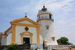
Guia Fortress | |
 Freguesia de São Lázaro in Macau | |
| Coordinates: 22°11′55″N 113°32′55″E / 22.19861°N 113.54861°ECoordinates: 22°11′55″N 113°32′55″E / 22.19861°N 113.54861°E | |
| Country | Macau, China |
| Region | Municipality of Macau |
| Area | |
| • Total | 0.64 km2 (0.25 sq mi) |
| Population (2013) | 33,100 |
| • Density | 52,000/km2 (130,000/sq mi) |
| • Density rank | 2 |
| Time zone | Macau Standard (UTC+8) |
| São Lázaro | |||||||||||||||||||
| Chinese name | |||||||||||||||||||
|---|---|---|---|---|---|---|---|---|---|---|---|---|---|---|---|---|---|---|---|
| Traditional Chinese | 望德堂區 | ||||||||||||||||||
| Simplified Chinese | 望德堂区 | ||||||||||||||||||
| Cantonese Yale | Mohngdák Tòhngkeu | ||||||||||||||||||
| Hanyu Pinyin | Wàngdé Tángqū | ||||||||||||||||||
| |||||||||||||||||||
| Portuguese name | |||||||||||||||||||
| Portuguese | Freguesia de São Lázaro | ||||||||||||||||||
Freguesia de São Lázaro (English:St. Lazarus Parish) is the smallest parish in Macau, located in the central-east region of the Macau Peninsula. It is surrounded by Freguesia de Nossa Senhora de Fátima, Freguesia de Santo António, and Freguesia da Sé. One-third of its region is covered by Guia Hill (Portuguese: Colina da Guia, Chinese: 松山 or 東望洋山). 3% of factories in Macau are located in the district.
Education
Infrastructures
Tourist attractions
- Archives of Macao
- Guia Fortress
- Lou Lim Ieoc Garden
- Macau Tea Culture House
- St. Lazarus' Church
- Sun Yat Sen Memorial House
- Tap Seac Multi-sports Pavilion
- Tap Seac Square
- Victory Garden
- Guia Municipal Park
- Guia Cable Car
- Jardim da Flora
- Guia Tunnel
- Estrada de Cacilhas
- Avenida do Conselheiro Ferreira de Almeida
See also
References
External links
| Wikimedia Commons has media related to São Lázaro. |
| Freguesias |
| |||||||
|---|---|---|---|---|---|---|---|---|
| Other zones | ||||||||
| Defunct subdivisions | ||||||||
| Defunct territories | ||||||||
Note: The freguesias are purely symbolic there are no political administrative subdivisions in Macau after the formation of Instituto para os Assuntos Cívicos e Municipais in 2002. | ||||||||
This article is issued from Wikipedia - version of the 10/28/2016. The text is available under the Creative Commons Attribution/Share Alike but additional terms may apply for the media files.